La Ceiba elevation
La Ceiba (Chiapas, Simojovel), Mexico elevation is 586 meters and La Ceiba elevation in feet is 1923 ft above sea level [src 1]. La Ceiba is a populated place (feature code) with elevation that is 728 meters (2388 ft) smaller than average city elevation in Mexico.
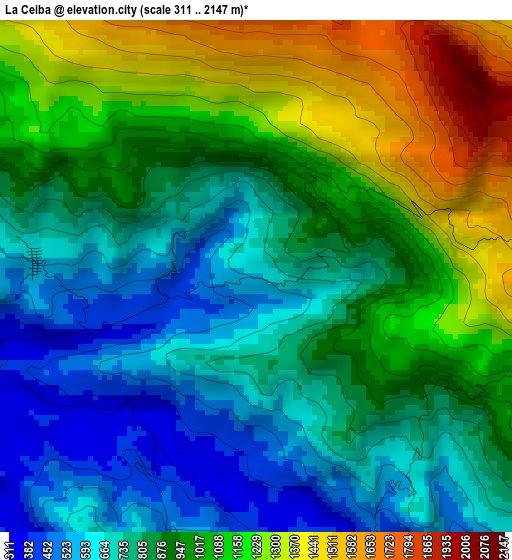
Below is the Elevation map of La Ceiba, which displays elevation range with different colors. Scale of the first map is from 311 to 2147 m (1020 to 7044 ft) with average elevation of 919.1 meters (=3015 ft) [note 1]
These maps also provides idea of topography and contour of this city, they are displayed at different zoom levels. More info about maps, scale and edge coordinates you can find below images.
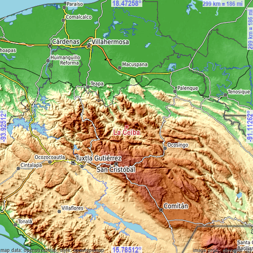
| \ | Map #1 | Topo.Map |
| Scale [m] | 311..2147 m | × |
| Scale [ft] | 1020..7044 ft | × |
| Average | 919.1 m = 3015 ft | × |
| Width | 9.34 km = 5.8 mi | 298.8 km = 185.7 mi |
| Height | 9.34 km = 5.8 mi | 298.8 km = 185.7 mi |
| ↑Max Latitude | 17.1757° | 18.47258° |
| Latitude at center | 17.13371° | 17.13371° |
| ↓Min Latitude | 17.09171° | 15.78512° |
| ← Min Longitude | -92.562815° | -93.92512° |
| Longitude center | -92.51887° | -92.51887° |
| →Max Longitude | -92.474925° | -91.11262° |
Nearby cities:
Cities around La Ceiba sort by population:
• Nuevo Sitalá elevation 1423 m
3.9 km,  80°
80°
• Aurora Esquipulas 1110 m
4.9 km,  112°
112°
• Shoctic 667 m
10.5 km,  18°
18°
• El Jardín 903 m
9.3 km,  293°
293°
• Chiquinshulum 1017 m
10.9 km,  230°
230°
• Joljá 843 m
8.1 km,  14°
14°
• El Calvario 980 m
10.2 km,  336°
336°
• Buenavista 597 m
10.2 km,  355°
355°
• Maravillas 609 m
4.1 km,  274°
274°
• Constitución 870 m
6.5 km,  184°
184°
• El Paraíso 537 m
13.2 km, 342°
• Joltealal 1072 m
12.6 km,  239°
239°
Multilingual:
 En español:
La Ceiba elevación 586 m.
 En France:
La Ceiba élévation 586 m.
 Auf Deutsch:
La Ceiba höhe über dem Meeresspiegel ist 586 m.

Sources and notes:
- [note 1] Map square and city borders are not equal. Map elevation data is calculated only from area inside that square.
- [src 1] Elevation data from geonames database provided with same terms of usage.
- [src 2] The elevation map of La Ceiba is generated using elevation data from NASA's 3 arcsec (90m) resolution SRTM data.
- [src 3] Base (background) map © OpenStreetMap contributors tiles are generated by Geofabrik and OpenTopoMap.
Copyright & License:
This La Ceiba Elevation Map is licensed under CC BY-SA. You may reuse any part from this page, if you give a proper credit by linking to this URL:
 More info on terms of use page.