Joljá elevation
Joljá (Chiapas, Tila), Mexico elevation is 843 meters and Joljá elevation in feet is 2766 ft above sea level [src 1]. Joljá is a populated place (feature code) with elevation that is 471 meters (1545 ft) smaller than average city elevation in Mexico.
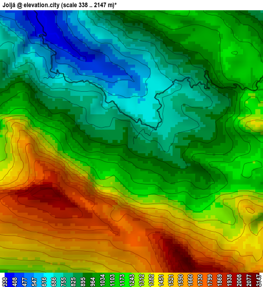
Below is the Elevation map of Joljá, which displays elevation range with different colors. Scale of the first map is from 338 to 2147 m (1109 to 7044 ft) with average elevation of 1147.8 meters (=3766 ft) [note 1]
These maps also provides idea of topography and contour of this city, they are displayed at different zoom levels. More info about maps, scale and edge coordinates you can find below images.
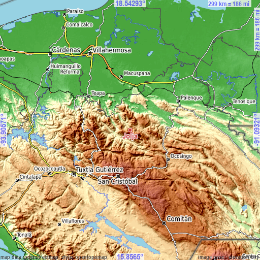
| \ | Map #1 | Topo.Map |
| Scale [m] | 338..2147 m | × |
| Scale [ft] | 1109..7044 ft | × |
| Average | 1147.8 m = 3766 ft | × |
| Width | 9.34 km = 5.8 mi | 298.7 km = 185.6 mi |
| Height | 9.34 km = 5.8 mi | 298.7 km = 185.6 mi |
| ↑Max Latitude | 17.246564° | 18.54293° |
| Latitude at center | 17.20459° | 17.20459° |
| ↓Min Latitude | 17.162606° | 15.8565° |
| ← Min Longitude | -92.543405° | -93.90571° |
| Longitude center | -92.49946° | -92.49946° |
| →Max Longitude | -92.455515° | -91.09321° |
Nearby cities:
Cities around Joljá sort by population:
• Petalcingo elevation 740 m
9.3 km,  74°
74°
• Chilón 720 m
9.4 km, 70°
• Nueva Esperanza 803 m
6.7 km,  44°
44°
• Nuevo Sitalá 1423 m
7.5 km,  166°
166°
• Aurora Esquipulas 1110 m
10 km, 165°
• Shoctic 667 m
2.4 km,  29°
29°
• La Ceiba 586 m
8.1 km,  194°
194°
• El Calvario 980 m
6.3 km,  283°
283°
• Buenavista 597 m
3.7 km,  308°
308°
• Maravillas 609 m
9.8 km,  219°
219°
• Jolsibaquil 1049 m
6.4 km,  17°
17°
• El Paraíso 537 m
7.7 km, 307°
Multilingual:
 En español:
Joljá elevación 843 m.
 En France:
Joljá élévation 843 m.


Sources and notes:
- [note 1] Map square and city borders are not equal. Map elevation data is calculated only from area inside that square.
- [src 1] Elevation data from geonames database provided with same terms of usage.
- [src 2] The elevation map of Joljá is generated using elevation data from NASA's 3 arcsec (90m) resolution SRTM data.
- [src 3] Base (background) map © OpenStreetMap contributors tiles are generated by Geofabrik and OpenTopoMap.
Copyright & License:
This Joljá Elevation Map is licensed under CC BY-SA. You may reuse any part from this page, if you give a proper credit by linking to this URL:
 More info on terms of use page.