Chiquinshulum elevation
Chiquinshulum (Chiapas, Chalchihuitán), Mexico elevation is 1017 meters and Chiquinshulum elevation in feet is 3337 ft above sea level [src 1]. Chiquinshulum is a populated place (feature code) with elevation that is 297 meters (974 ft) smaller than average city elevation in Mexico.
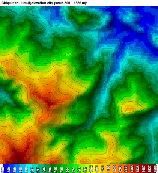
Below is the Elevation map of Chiquinshulum, which displays elevation range with different colors. Scale of the first map is from 300 to 1586 m (984 to 5203 ft) with average elevation of 818.8 meters (=2686 ft) [note 1]
These maps also provides idea of topography and contour of this city, they are displayed at different zoom levels. More info about maps, scale and edge coordinates you can find below images.
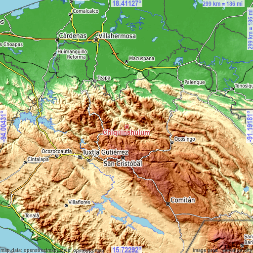
| \ | Map #1 | Topo.Map |
| Scale [m] | 300..1586 m | × |
| Scale [ft] | 984..5203 ft | × |
| Average | 818.8 m = 2686 ft | × |
| Width | 9.34 km = 5.8 mi | 298.9 km = 185.7 mi |
| Height | 9.34 km = 5.8 mi | 298.9 km = 185.7 mi |
| ↑Max Latitude | 17.113944° | 18.41127° |
| Latitude at center | 17.07194° | 17.07194° |
| ↓Min Latitude | 17.029926° | 15.72292° |
| ← Min Longitude | -92.642005° | -94.00431° |
| Longitude center | -92.59806° | -92.59806° |
| →Max Longitude | -92.554115° | -91.19181° |
Nearby cities:
Cities around Chiquinshulum sort by population:
• Simojovel de Allende elevation 700 m
14.5 km,  301°
301°
• El Bosque 1082 m
13.2 km,  265°
265°
• Huitiupán 306 m
14.6 km,  320°
320°
• Nuevo Sitalá 1423 m
14.4 km,  58°
58°
• Aurora Esquipulas 1110 m
13.9 km,  68°
68°
• San Pedro Nichtalucum 948 m
14.3 km,  253°
253°
• El Jardín 903 m
10.5 km,  359°
359°
• La Ceiba 586 m
10.9 km,  50°
50°
• Maravillas 609 m
8.4 km,  30°
30°
• Constitución 870 m
7.9 km,  87°
87°
• Chalchihuitán 1475 m
12.2 km,  190°
190°
• Joltealal 1072 m
2.6 km,  282°
282°
Multilingual:
 En español:
Chiquinshulum elevación 1017 m.
 En France:
Chiquinshulum élévation 1017 m.
 Auf Deutsch:
Chiquinshulum höhe über dem Meeresspiegel ist 1017 m.

Sources and notes:
- [note 1] Map square and city borders are not equal. Map elevation data is calculated only from area inside that square.
- [src 1] Elevation data from geonames database provided with same terms of usage.
- [src 2] The elevation map of Chiquinshulum is generated using elevation data from NASA's 3 arcsec (90m) resolution SRTM data.
- [src 3] Base (background) map © OpenStreetMap contributors tiles are generated by Geofabrik and OpenTopoMap.
Copyright & License:
This Chiquinshulum Elevation Map is licensed under CC BY-SA. You may reuse any part from this page, if you give a proper credit by linking to this URL:
 More info on terms of use page.