El Bosque elevation
El Bosque (Chiapas), Mexico elevation is 1082 meters and El Bosque elevation in feet is 3550 ft above sea level [src 1]. El Bosque is a seat of a second-order administrative division (feature code) with elevation that is 232 meters (761 ft) smaller than average city elevation in Mexico.
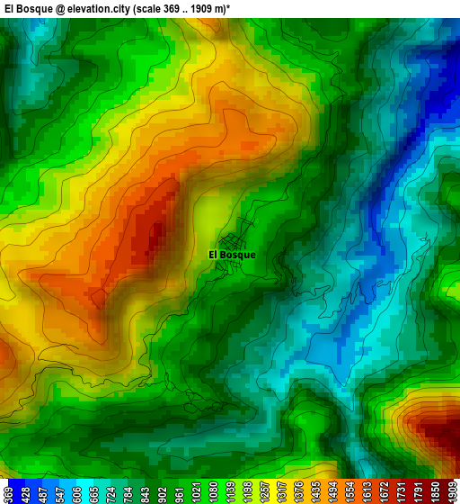
Below is the Elevation map of El Bosque, which displays elevation range with different colors. Scale of the first map is from 369 to 1909 m (1211 to 6263 ft) with average elevation of 1032.4 meters (=3387 ft) [note 1]
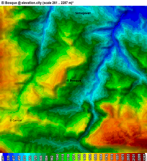
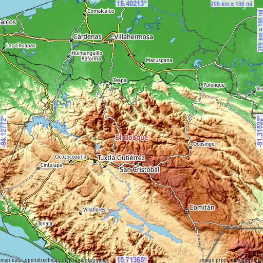
These maps also provides idea of topography and contour of this city, they are displayed at different zoom levels. More info about maps, scale and edge coordinates you can find below images.
| \ | Map #1 | Map #2 | Topo.Map |
| Scale [m] | 369..1909 m | 261..2287 m | × |
| Scale [ft] | 1211..6263 ft | 856..7503 ft | × |
| Average | 1032.4 m = 3387 ft | 1100.8 m = 3612 ft | × |
| Width | 9.34 km = 5.8 mi | 18.68 km = 11.6 mi | 298.9 km = 185.7 mi |
| Height | 9.34 km = 5.8 mi | 18.68 km = 11.6 mi | 299 km = 185.8 mi |
| ↑Max Latitude | 17.104736° | 17.146733° | 18.40213° |
| Latitude at center | 17.06273° | 17.06273° | 17.06273° |
| ↓Min Latitude | 17.020714° | 16.978689° | 15.71365° |
| ← Min Longitude | -92.765415° | -92.809361° | -94.12772° |
| Longitude center | -92.72147° | -92.72147° | -92.72147° |
| →Max Longitude | -92.677525° | -92.633579° | -91.31522° |
Nearby cities:
Cities around El Bosque sort by population:
• Simojovel de Allende elevation 700 m
8.7 km,  5°
5°
• San Andrés Duraznal 1579 m
11.7 km,  310°
310°
• Huitiupán 306 m
12.8 km,  17°
17°
• Carmen Zacatal 1628 m
8.8 km,  283°
283°
• Los Plátanos 1183 m
6.7 km,  199°
199°
• San Pedro Nichtalucum 948 m
3.2 km,  190°
190°
• San Cayetano 1511 m
12 km, 200°
• La Pimienta 823 m
9.7 km,  333°
333°
• Chiquinshulum 1017 m
13.2 km,  85°
85°
• Cálido 1318 m
8.1 km,  299°
299°
• El Ámbar 1605 m
12.7 km,  250°
250°
• Joltealal 1072 m
10.7 km,  81°
81°
Multilingual:
 En español:
El Bosque elevación 1082 m.
 En France:
El Bosque élévation 1082 m.
 Auf Deutsch:
El Bosque höhe über dem Meeresspiegel ist 1082 m.

Sources and notes:
- [note 1] Map square and city borders are not equal. Map elevation data is calculated only from area inside that square.
- [src 1] Elevation data from geonames database provided with same terms of usage.
- [src 2] The elevation map of El Bosque is generated using elevation data from NASA's 3 arcsec (90m) resolution SRTM data.
- [src 3] Base (background) map © OpenStreetMap contributors tiles are generated by Geofabrik and OpenTopoMap.
Copyright & License:
This El Bosque Elevation Map is licensed under CC BY-SA. You may reuse any part from this page, if you give a proper credit by linking to this URL:
 More info on terms of use page.