Tenango elevation
Tenango (Chiapas, San Juan Cancuc), Mexico elevation is 1880 meters and Tenango elevation in feet is 6168 ft above sea level [src 1]. Tenango is a populated place (feature code) with elevation that is 566 meters (1857 ft) bigger than average city elevation in Mexico.
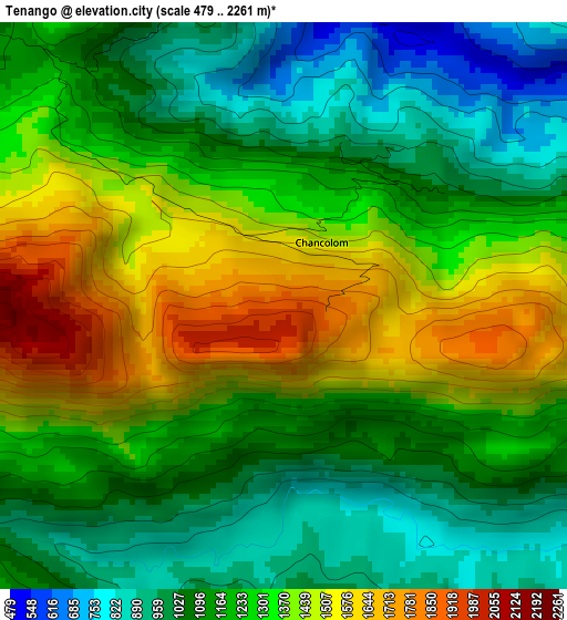
Below is the Elevation map of Tenango, which displays elevation range with different colors. Scale of the first map is from 479 to 2261 m (1572 to 7418 ft) with average elevation of 1235 meters (=4052 ft) [note 1]
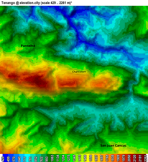
These maps also provides idea of topography and contour of this city, they are displayed at different zoom levels. More info about maps, scale and edge coordinates you can find below images.
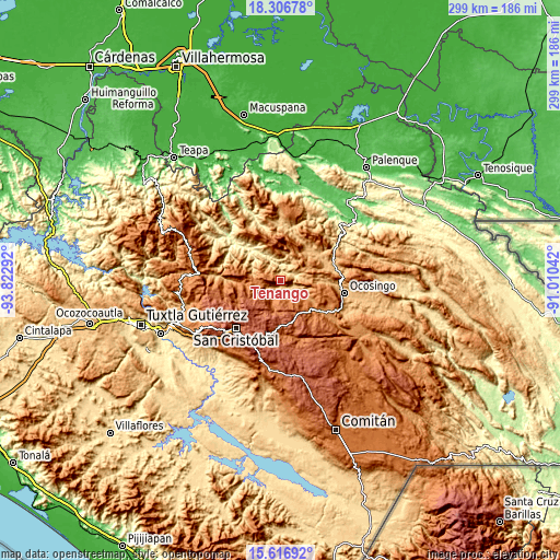
| \ | Map #1 | Map #2 | Topo.Map |
| Scale [m] | 479..2261 m | 429..2261 m | × |
| Scale [ft] | 1572..7418 ft | 1407..7418 ft | × |
| Average | 1235 m = 4052 ft | 1122.4 m = 3682 ft | × |
| Width | 9.35 km = 5.8 mi | 18.69 km = 11.6 mi | 299.1 km = 185.9 mi |
| Height | 9.35 km = 5.8 mi | 18.69 km = 11.6 mi | 299.1 km = 185.9 mi |
| ↑Max Latitude | 17.008698° | 17.050716° | 18.30678° |
| Latitude at center | 16.96667° | 16.96667° | 16.96667° |
| ↓Min Latitude | 16.924633° | 16.882586° | 15.61692° |
| ← Min Longitude | -92.460615° | -92.504561° | -93.82292° |
| Longitude center | -92.41667° | -92.41667° | -92.41667° |
| →Max Longitude | -92.372725° | -92.328779° | -91.01042° |
Nearby cities:
Cities around Tenango sort by population:
• Pantelhó elevation 1203 m
7.3 km,  306°
306°
• San Juan Cancuc 1415 m
9.6 km,  148°
148°
• Cancuc 1302 m
9 km,  231°
231°
• Chiloljá 1602 m
9.1 km,  185°
185°
• Tzeltal 1226 m
7.2 km,  245°
245°
• El Pozo 1077 m
5.2 km,  174°
174°
• Chixtontic 1410 m
9.5 km,  207°
207°
• Yibeljoj 1477 m
9.3 km,  263°
263°
• Puebla 1391 m
10.9 km,  238°
238°
• Tres Cerros 1321 m
8.2 km, 226°
• Miguel Utrilla (Los Chorros) 1312 m
7.2 km, 248°
• Jomanichim 1386 m
9.4 km,  218°
218°
Multilingual:
 En español:
Tenango elevación 1880 m.
 En France:
Tenango élévation 1880 m.
 Auf Deutsch:
Tenango höhe über dem Meeresspiegel ist 1880 m.

Sources and notes:
- [note 1] Map square and city borders are not equal. Map elevation data is calculated only from area inside that square.
- [src 1] Elevation data from geonames database provided with same terms of usage.
- [src 2] The elevation map of Tenango is generated using elevation data from NASA's 3 arcsec (90m) resolution SRTM data.
- [src 3] Base (background) map © OpenStreetMap contributors tiles are generated by Geofabrik and OpenTopoMap.
Copyright & License:
This Tenango Elevation Map is licensed under CC BY-SA. You may reuse any part from this page, if you give a proper credit by linking to this URL:
 More info on terms of use page.