San Juan Cancuc elevation
San Juan Cancuc (Chiapas), Mexico elevation is 1415 meters and San Juan Cancuc elevation in feet is 4642 ft above sea level [src 1]. San Juan Cancuc is a seat of a second-order administrative division (feature code) with elevation that is 101 meters (331 ft) bigger than average city elevation in Mexico.
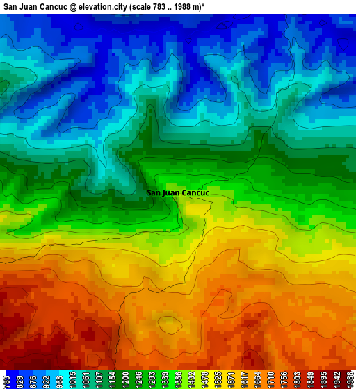
Below is the Elevation map of San Juan Cancuc, which displays elevation range with different colors. Scale of the first map is from 783 to 1988 m (2569 to 6522 ft) with average elevation of 1295.3 meters (=4250 ft) [note 1]
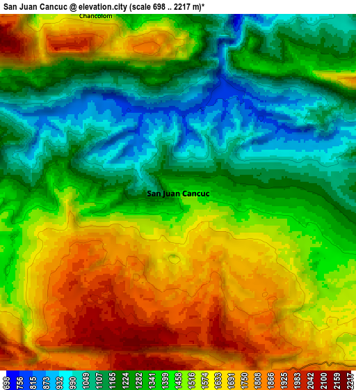
These maps also provides idea of topography and contour of this city, they are displayed at different zoom levels. More info about maps, scale and edge coordinates you can find below images.
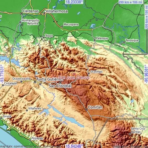
| \ | Map #1 | Map #2 | Topo.Map |
| Scale [m] | 783..1988 m | 698..2217 m | × |
| Scale [ft] | 2569..6522 ft | 2290..7274 ft | × |
| Average | 1295.3 m = 4250 ft | 1425.5 m = 4677 ft | × |
| Width | 9.35 km = 5.8 mi | 18.7 km = 11.6 mi | 299.2 km = 185.9 mi |
| Height | 9.35 km = 5.8 mi | 18.7 km = 11.6 mi | 299.2 km = 185.9 mi |
| ↑Max Latitude | 16.934764° | 16.976799° | 18.23338° |
| Latitude at center | 16.89272° | 16.89272° | 16.89272° |
| ↓Min Latitude | 16.850666° | 16.808603° | 15.54246° |
| ← Min Longitude | -92.414005° | -92.457951° | -93.77631° |
| Longitude center | -92.37006° | -92.37006° | -92.37006° |
| →Max Longitude | -92.326115° | -92.282169° | -90.96381° |
Nearby cities:
Cities around San Juan Cancuc sort by population:
• Tenango elevation 1880 m
9.6 km,  328°
328°
• Yoshib 1607 m
9.7 km,  236°
236°
• Kotolte 1485 m
10.2 km,  252°
252°
• Chiloljá 1602 m
5.9 km,  261°
261°
• Tzajalchén 1550 m
11.1 km, 239°
• Tz'Aquiviljok 1454 m
10.4 km, 246°
• Yashanal 1706 m
11.2 km,  230°
230°
• El Pozo 1077 m
5.4 km,  304°
304°
• El Tzay 1523 m
7 km,  117°
117°
• Chixtontic 1410 m
9.4 km,  268°
268°
• Sibaniljá Pocolum 1478 m
9.9 km, 259°
• Jomanichim 1386 m
10.9 km, 274°
Multilingual:
 En español:
San Juan Cancuc elevación 1415 m.
 En France:
San Juan Cancuc élévation 1415 m.
 Auf Deutsch:
San Juan Cancuc höhe über dem Meeresspiegel ist 1415 m.

Sources and notes:
- [note 1] Map square and city borders are not equal. Map elevation data is calculated only from area inside that square.
- [src 1] Elevation data from geonames database provided with same terms of usage.
- [src 2] The elevation map of San Juan Cancuc is generated using elevation data from NASA's 3 arcsec (90m) resolution SRTM data.
- [src 3] Base (background) map © OpenStreetMap contributors tiles are generated by Geofabrik and OpenTopoMap.
Copyright & License:
This San Juan Cancuc Elevation Map is licensed under CC BY-SA. You may reuse any part from this page, if you give a proper credit by linking to this URL:
 More info on terms of use page.