Yoshib elevation
Yoshib (Chiapas, Oxchuc), Mexico elevation is 1607 meters and Yoshib elevation in feet is 5272 ft above sea level [src 1]. Yoshib is a populated place (feature code) with elevation that is 293 meters (961 ft) bigger than average city elevation in Mexico.
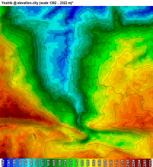
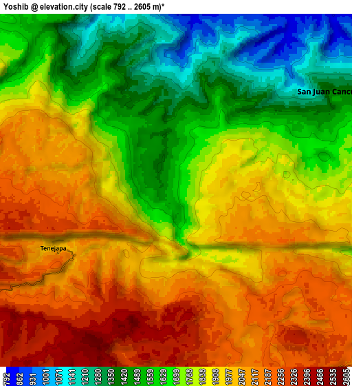
Below is the Elevation map of Yoshib, which displays elevation range with different colors. Scale of the first map is from 1302 to 2322 m (4272 to 7618 ft) with average elevation of 1794.1 meters (=5886 ft) [note 1]
These maps also provides idea of topography and contour of this city, they are displayed at different zoom levels. More info about maps, scale and edge coordinates you can find below images.
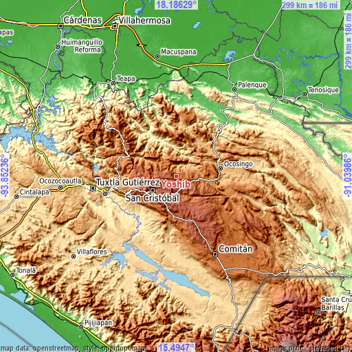
| \ | Map #1 | Map #2 | Topo.Map |
| Scale [m] | 1302..2322 m | 792..2605 m | × |
| Scale [ft] | 4272..7618 ft | 2598..8547 ft | × |
| Average | 1794.1 m = 5886 ft | 1828.2 m = 5998 ft | × |
| Width | 9.35 km = 5.8 mi | 18.71 km = 11.6 mi | 299.3 km = 186 mi |
| Height | 9.35 km = 5.8 mi | 18.71 km = 11.6 mi | 299.3 km = 186 mi |
| ↑Max Latitude | 16.887335° | 16.929381° | 18.18629° |
| Latitude at center | 16.84528° | 16.84528° | 16.84528° |
| ↓Min Latitude | 16.803216° | 16.761142° | 15.4947° |
| ← Min Longitude | -92.490055° | -92.534001° | -93.85236° |
| Longitude center | -92.44611° | -92.44611° | -92.44611° |
| →Max Longitude | -92.402165° | -92.358219° | -91.03986° |
Nearby cities:
Cities around Yoshib sort by population:
• Kotolte elevation 1485 m
2.7 km,  323°
323°
• Chiloljá 1602 m
5 km,  27°
27°
• Tzajalchén 1550 m
1.5 km,  254°
254°
• Tz'Aquiviljok 1454 m
1.8 km,  307°
307°
• Tenejapa 2013 m
7.1 km, 245°
• Yashanal 1706 m
1.9 km,  198°
198°
• Matzam 2384 m
7 km,  207°
207°
• Chixtontic 1410 m
5.2 km,  346°
346°
• Chacoma 1895 m
5.9 km, 305°
• Sibaniljá Pocolum 1478 m
3.8 km,  335°
335°
• Ococh 1943 m
3.2 km,  255°
255°
• Jomanichim 1386 m
6.7 km, 335°
Multilingual:
 En español:
Yoshib elevación 1607 m.
 En France:
Yoshib élévation 1607 m.


Sources and notes:
- [note 1] Map square and city borders are not equal. Map elevation data is calculated only from area inside that square.
- [src 1] Elevation data from geonames database provided with same terms of usage.
- [src 2] The elevation map of Yoshib is generated using elevation data from NASA's 3 arcsec (90m) resolution SRTM data.
- [src 3] Base (background) map © OpenStreetMap contributors tiles are generated by Geofabrik and OpenTopoMap.
Copyright & License:
This Yoshib Elevation Map is licensed under CC BY-SA. You may reuse any part from this page, if you give a proper credit by linking to this URL:
 More info on terms of use page.