El Tzay elevation
El Tzay (Chiapas, Oxchuc), Mexico elevation is 1523 meters and El Tzay elevation in feet is 4997 ft above sea level [src 1]. El Tzay is a populated place (feature code) with elevation that is 209 meters (686 ft) bigger than average city elevation in Mexico.
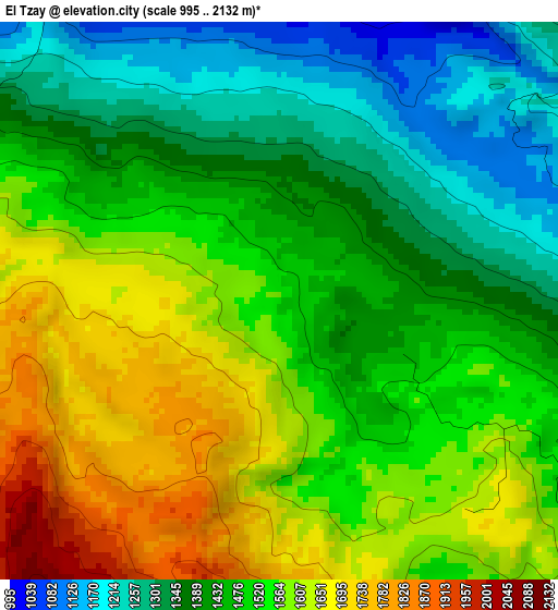
Below is the Elevation map of El Tzay, which displays elevation range with different colors. Scale of the first map is from 995 to 2132 m (3264 to 6995 ft) with average elevation of 1492.3 meters (=4896 ft) [note 1]
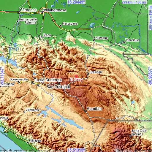
These maps also provides idea of topography and contour of this city, they are displayed at different zoom levels. More info about maps, scale and edge coordinates you can find below images.
| \ | Map #1 | Topo.Map |
| Scale [m] | 995..2132 m | × |
| Scale [ft] | 3264..6995 ft | × |
| Average | 1492.3 m = 4896 ft | × |
| Width | 9.35 km = 5.8 mi | 299.2 km = 185.9 mi |
| Height | 9.35 km = 5.8 mi | 299.3 km = 186 mi |
| ↑Max Latitude | 16.905661° | 18.20449° |
| Latitude at center | 16.86361° | 16.86361° |
| ↓Min Latitude | 16.82155° | 15.51315° |
| ← Min Longitude | -92.356165° | -93.71847° |
| Longitude center | -92.31222° | -92.31222° |
| →Max Longitude | -92.268275° | -90.90597° |
Nearby cities:
Cities around El Tzay sort by population:
• Oxchuc elevation 1967 m
9.3 km,  201°
201°
• San Juan Cancuc 1415 m
7 km,  297°
297°
• Tenango 1297 m
7.1 km,  49°
49°
• Yoshib 1607 m
14.4 km,  261°
261°
• Abasolo 1283 m
11.3 km,  114°
114°
• Guaquitepec 1064 m
13.2 km,  11°
11°
• Chiloljá 1602 m
12.2 km,  281°
281°
• Tz'Aquiviljok 1454 m
15.7 km,  266°
266°
• Yashanal 1706 m
15.4 km, 255°
• El Pozo 1077 m
12.3 km, 300°
• Tzopilja 2130 m
13.8 km,  178°
178°
• San Antonio Bulujib 1047 m
14.9 km, 6°
Multilingual:
 En español:
El Tzay elevación 1523 m.
 En France:
El Tzay élévation 1523 m.
 Auf Deutsch:
El Tzay höhe über dem Meeresspiegel ist 1523 m.

Sources and notes:
- [note 1] Map square and city borders are not equal. Map elevation data is calculated only from area inside that square.
- [src 1] Elevation data from geonames database provided with same terms of usage.
- [src 2] The elevation map of El Tzay is generated using elevation data from NASA's 3 arcsec (90m) resolution SRTM data.
- [src 3] Base (background) map © OpenStreetMap contributors tiles are generated by Geofabrik and OpenTopoMap.
Copyright & License:
This El Tzay Elevation Map is licensed under CC BY-SA. You may reuse any part from this page, if you give a proper credit by linking to this URL:
 More info on terms of use page.