Cuquío elevation
Cuquío (Jalisco), Mexico elevation is 1781 meters and Cuquío elevation in feet is 5843 ft above sea level [src 1]. Cuquío is a seat of a second-order administrative division (feature code) with elevation that is 467 meters (1532 ft) bigger than average city elevation in Mexico.
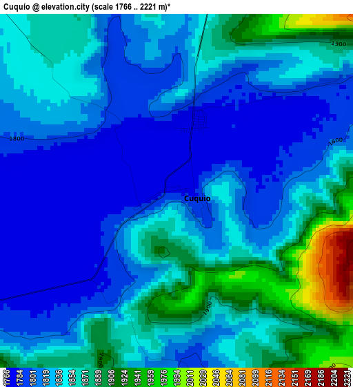
Below is the Elevation map of Cuquío, which displays elevation range with different colors. Scale of the first map is from 1766 to 2221 m (5794 to 7287 ft) with average elevation of 1839.5 meters (=6035 ft) [note 1]
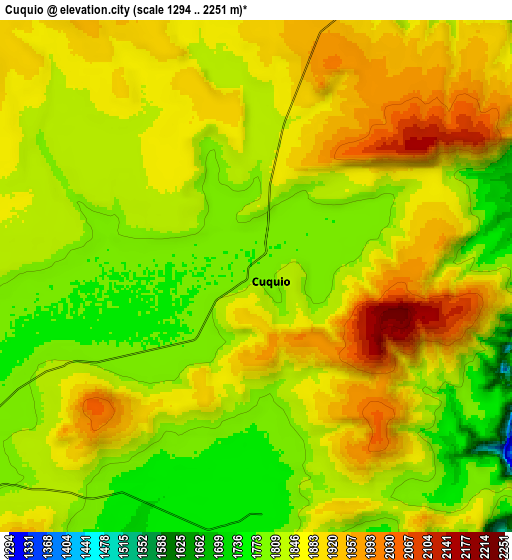
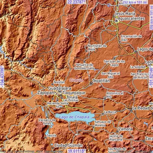
These maps also provides idea of topography and contour of this city, they are displayed at different zoom levels. More info about maps, scale and edge coordinates you can find below images.
| \ | Map #1 | Map #2 | Topo.Map |
| Scale [m] | 1766..2221 m | 1294..2251 m | × |
| Scale [ft] | 5794..7287 ft | 4245..7385 ft | × |
| Average | 1839.5 m = 6035 ft | 1849 m = 6066 ft | × |
| Width | 9.13 km = 5.7 mi | 18.26 km = 11.3 mi | 292.1 km = 181.5 mi |
| Height | 9.13 km = 5.7 mi | 18.26 km = 11.3 mi | 292.1 km = 181.5 mi |
| ↑Max Latitude | 20.97131° | 21.012339° | 22.23787° |
| Latitude at center | 20.93027° | 20.93027° | 20.93027° |
| ↓Min Latitude | 20.889219° | 20.848156° | 19.61115° |
| ← Min Longitude | -103.071655° | -103.115601° | -104.43396° |
| Longitude center | -103.02771° | -103.02771° | -103.02771° |
| →Max Longitude | -102.983765° | -102.939819° | -101.62146° |
Nearby cities:
Cities around Cuquío sort by population:
• Acatic elevation 1684 m
20.7 km,  143°
143°
• Ixtlahuacán del Río 1638 m
23.3 km,  251°
251°
• San Gabriel 1892 m
9.9 km,  8°
8°
• El Refugio 1777 m
26.4 km,  149°
149°
• Mezcala 1673 m
19 km,  82°
82°
• Matatlán 1563 m
27.6 km,  207°
207°
• San Antonio de los Vázquez 1693 m
17.6 km,  224°
224°
• Trejos 1637 m
23.2 km,  229°
229°
• Lázaro Cárdenas 1778 m
1.8 km,  18°
18°
• Manalisco 1752 m
18.1 km,  37°
37°
• Palos Altos 1780 m
14.6 km,  243°
243°
• La Purísima 1625 m
25.4 km,  181°
181°
Multilingual:
 En español:
Cuquío elevación 1781 m.
 En France:
Cuquío élévation 1781 m.


Sources and notes:
- [note 1] Map square and city borders are not equal. Map elevation data is calculated only from area inside that square.
- [src 1] Elevation data from geonames database provided with same terms of usage.
- [src 2] The elevation map of Cuquío is generated using elevation data from NASA's 3 arcsec (90m) resolution SRTM data.
- [src 3] Base (background) map © OpenStreetMap contributors tiles are generated by Geofabrik and OpenTopoMap.
Copyright & License:
This Cuquío Elevation Map is licensed under CC BY-SA. You may reuse any part from this page, if you give a proper credit by linking to this URL:
 More info on terms of use page.