Ixtlahuacán del Río elevation
Ixtlahuacán del Río (Jalisco), Mexico elevation is 1638 meters and Ixtlahuacán del Río elevation in feet is 5374 ft above sea level [src 1]. Ixtlahuacán del Río is a seat of a second-order administrative division (feature code) with elevation that is 324 meters (1063 ft) bigger than average city elevation in Mexico.
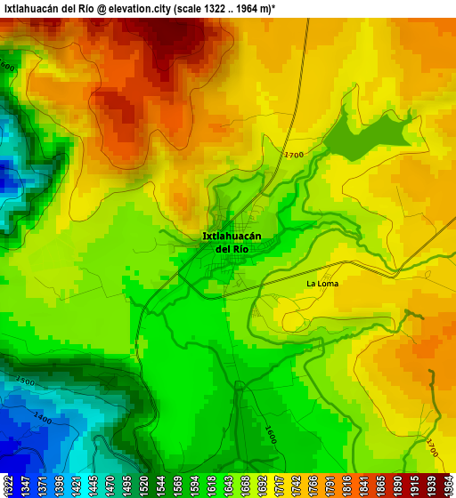
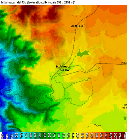
Below is the Elevation map of Ixtlahuacán del Río, which displays elevation range with different colors. Scale of the first map is from 1322 to 1964 m (4337 to 6444 ft) with average elevation of 1676.6 meters (=5501 ft) [note 1]
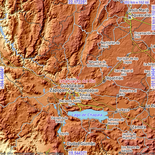
These maps also provides idea of topography and contour of this city, they are displayed at different zoom levels. More info about maps, scale and edge coordinates you can find below images.
| \ | Map #1 | Map #2 | Topo.Map |
| Scale [m] | 1322..1964 m | 899..2192 m | × |
| Scale [ft] | 4337..6444 ft | 2949..7192 ft | × |
| Average | 1676.6 m = 5501 ft | 1633.5 m = 5359 ft | × |
| Width | 9.13 km = 5.7 mi | 18.26 km = 11.3 mi | 292.2 km = 181.6 mi |
| Height | 9.13 km = 5.7 mi | 18.26 km = 11.3 mi | 292.2 km = 181.6 mi |
| ↑Max Latitude | 20.905108° | 20.946155° | 22.17225° |
| Latitude at center | 20.86405° | 20.86405° | 20.86405° |
| ↓Min Latitude | 20.822981° | 20.7819° | 19.54437° |
| ← Min Longitude | -103.284235° | -103.328181° | -104.64654° |
| Longitude center | -103.24029° | -103.24029° | -103.24029° |
| →Max Longitude | -103.196345° | -103.152399° | -101.83404° |
Nearby cities:
Cities around Ixtlahuacán del Río sort by population:
• Zapopan elevation 1568 m
21.7 km,  223°
223°
• Coyula 1572 m
22.9 km,  176°
176°
• Cuquío 1781 m
23.3 km,  71°
71°
• Campestre las Palomas [Fraccionamiento] 1616 m
22.6 km,  256°
256°
• San Esteban (San Miguel Tateposco) 1418 m
15.7 km,  242°
242°
• Zapopan2 1552 m
23.3 km,  225°
225°
• Campo Real 1600 m
22.7 km,  247°
247°
• Matatlán 1563 m
19.5 km,  151°
151°
• San Antonio de los Vázquez 1693 m
11.1 km,  117°
117°
• San Isidro 1370 m
14.1 km, 234°
• Trejos 1637 m
9 km, 149°
• Palos Altos 1780 m
9.1 km,  84°
84°
Multilingual:
 En español:
Ixtlahuacán del Río elevación 1638 m.
 En France:
Ixtlahuacán del Río élévation 1638 m.
 Auf Deutsch:
Ixtlahuacán del Río höhe über dem Meeresspiegel ist 1638 m.
 На русском:
Ixtlahuacán del Río высота над уровнем моря 1638 м
Sources and notes:
- [note 1] Map square and city borders are not equal. Map elevation data is calculated only from area inside that square.
- [src 1] Elevation data from geonames database provided with same terms of usage.
- [src 2] The elevation map of Ixtlahuacán del Río is generated using elevation data from NASA's 3 arcsec (90m) resolution SRTM data.
- [src 3] Base (background) map © OpenStreetMap contributors tiles are generated by Geofabrik and OpenTopoMap.
Copyright & License:
This Ixtlahuacán del Río Elevation Map is licensed under CC BY-SA. You may reuse any part from this page, if you give a proper credit by linking to this URL:
 More info on terms of use page.