Trejos elevation
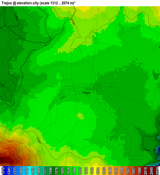
Trejos (Jalisco, Ixtlahuacán del Río), Mexico elevation is 1637 meters and Trejos elevation in feet is 5371 ft above sea level [src 1]. Trejos is a populated place (feature code) with elevation that is 323 meters (1060 ft) bigger than average city elevation in Mexico.
Below is the Elevation map of Trejos, which displays elevation range with different colors. Scale of the first map is from 1312 to 2074 m (4304 to 6804 ft) with average elevation of 1663.1 meters (=5456 ft) [note 1]
These maps also provides idea of topography and contour of this city, they are displayed at different zoom levels. More info about maps, scale and edge coordinates you can find below images.
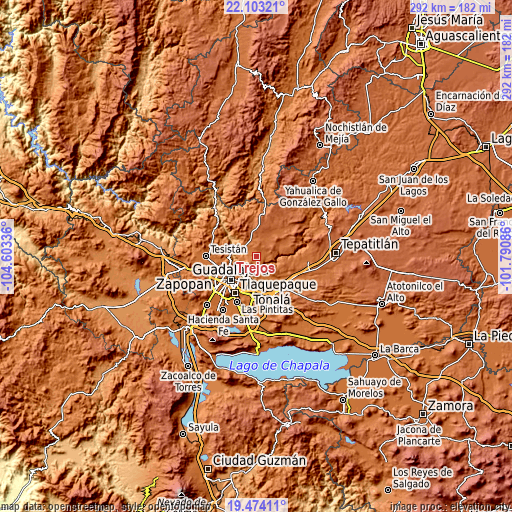
| \ | Map #1 | Topo.Map |
| Scale [m] | 1312..2074 m | × |
| Scale [ft] | 4304..6804 ft | × |
| Average | 1663.1 m = 5456 ft | × |
| Width | 9.14 km = 5.7 mi | 292.3 km = 181.6 mi |
| Height | 9.14 km = 5.7 mi | 292.3 km = 181.6 mi |
| ↑Max Latitude | 20.835467° | 22.10321° |
| Latitude at center | 20.79439° | 20.79439° |
| ↓Min Latitude | 20.753302° | 19.47411° |
| ← Min Longitude | -103.241055° | -104.60336° |
| Longitude center | -103.19711° | -103.19711° |
| →Max Longitude | -103.153165° | -101.79086° |
Nearby cities:
Cities around Trejos sort by population:
• Tlaquepaque elevation 1581 m
19.8 km,  210°
210°
• Tonalá 1660 m
19.3 km,  191°
191°
• Coyula 1572 m
15.4 km, 191°
• Ixtlahuacán del Río 1638 m
9 km,  329°
329°
• San Esteban (San Miguel Tateposco) 1418 m
18.4 km,  271°
271°
• Mismaloya (Fraccionamiento Pedregal de Santa Martha) 1567 m
21 km,  172°
172°
• Paseo de las Cañadas 1558 m
19.2 km,  180°
180°
• Matatlán 1563 m
10.6 km,  152°
152°
• San Antonio de los Vázquez 1693 m
5.9 km,  63°
63°
• San Isidro 1370 m
16 km, 268°
• Palos Altos 1780 m
9.7 km,  28°
28°
• La Purísima 1625 m
20 km,  120°
120°
Multilingual:
 En español:
Trejos elevación 1637 m.
 En France:
Trejos élévation 1637 m.


Sources and notes:
- [note 1] Map square and city borders are not equal. Map elevation data is calculated only from area inside that square.
- [src 1] Elevation data from geonames database provided with same terms of usage.
- [src 2] The elevation map of Trejos is generated using elevation data from NASA's 3 arcsec (90m) resolution SRTM data.
- [src 3] Base (background) map © OpenStreetMap contributors tiles are generated by Geofabrik and OpenTopoMap.
Copyright & License:
This Trejos Elevation Map is licensed under CC BY-SA. You may reuse any part from this page, if you give a proper credit by linking to this URL:
 More info on terms of use page.