Tonalá elevation
Tonalá (Jalisco), Mexico elevation is 1660 meters and Tonalá elevation in feet is 5446 ft above sea level [src 1]. Tonalá is a seat of a second-order administrative division (feature code) with elevation that is 346 meters (1135 ft) bigger than average city elevation in Mexico.
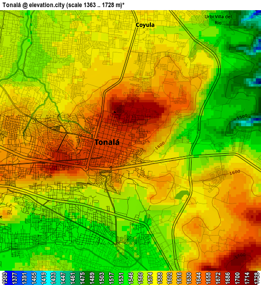
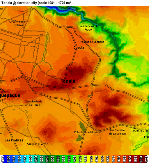
Below is the Elevation map of Tonalá, which displays elevation range with different colors. Scale of the first map is from 1363 to 1728 m (4472 to 5669 ft) with average elevation of 1582.9 meters (=5193 ft) [note 1]
These maps also provides idea of topography and contour of this city, they are displayed at different zoom levels. More info about maps, scale and edge coordinates you can find below images.
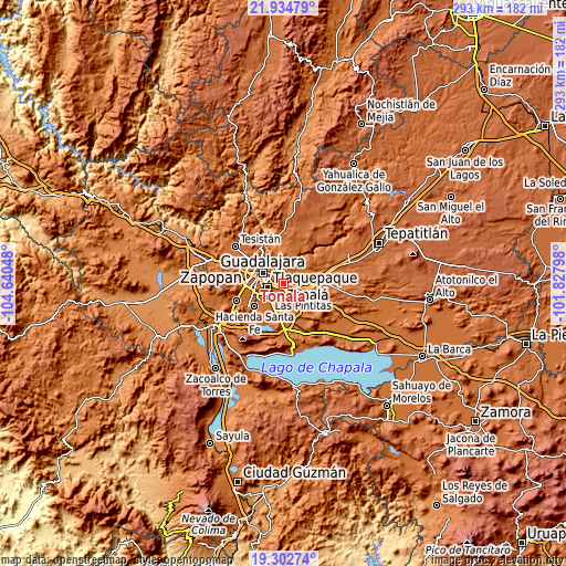
| \ | Map #1 | Map #2 | Topo.Map |
| Scale [m] | 1363..1728 m | 1081..1729 m | × |
| Scale [ft] | 4472..5669 ft | 3547..5673 ft | × |
| Average | 1582.9 m = 5193 ft | 1541.9 m = 5059 ft | × |
| Width | 9.15 km = 5.7 mi | 18.29 km = 11.4 mi | 292.7 km = 181.9 mi |
| Height | 9.15 km = 5.7 mi | 18.29 km = 11.4 mi | 292.7 km = 181.9 mi |
| ↑Max Latitude | 20.665573° | 20.706685° | 21.93479° |
| Latitude at center | 20.62445° | 20.62445° | 20.62445° |
| ↓Min Latitude | 20.583316° | 20.54217° | 19.30274° |
| ← Min Longitude | -103.278175° | -103.322121° | -104.64048° |
| Longitude center | -103.23423° | -103.23423° | -103.23423° |
| →Max Longitude | -103.190285° | -103.146339° | -101.82798° |
Nearby cities:
Cities around Tonalá sort by population:
• Tlaquepaque elevation 1581 m
6.4 km,  286°
286°
• Coyula 1572 m
3.9 km,  11°
11°
• Las Pintitas 1541 m
9.7 km,  226°
226°
• Centro de Readaptación Social 1564 m
8.9 km,  151°
151°
• El Verde 1542 m
9 km,  211°
211°
• Puente Grande 1475 m
10.3 km,  125°
125°
• La Punta 1567 m
6.3 km,  158°
158°
• Paseo Puente Viejo 1552 m
7.6 km,  143°
143°
• Mismaloya (Fraccionamiento Pedregal de Santa Martha) 1567 m
6.8 km,  106°
106°
• Paseo de las Cañadas 1558 m
3.8 km,  95°
95°
• Hacienda Vieja del Castillo (Castillo Viejo) 1539 m
9.4 km,  186°
186°
• Colonia Guadalupana 1542 m
6.6 km,  166°
166°
Multilingual:
 En español:
Tonalá elevación 1660 m.
 En France:
Tonalá élévation 1660 m.


Sources and notes:
- [note 1] Map square and city borders are not equal. Map elevation data is calculated only from area inside that square.
- [src 1] Elevation data from geonames database provided with same terms of usage.
- [src 2] The elevation map of Tonalá is generated using elevation data from NASA's 3 arcsec (90m) resolution SRTM data.
- [src 3] Base (background) map © OpenStreetMap contributors tiles are generated by Geofabrik and OpenTopoMap.
Copyright & License:
This Tonalá Elevation Map is licensed under CC BY-SA. You may reuse any part from this page, if you give a proper credit by linking to this URL:
 More info on terms of use page.