Las Pintitas elevation
Las Pintitas (Jalisco, El Salto), Mexico elevation is 1541 meters and Las Pintitas elevation in feet is 5056 ft above sea level [src 1]. Las Pintitas is a populated place (feature code) with elevation that is 227 meters (745 ft) bigger than average city elevation in Mexico.
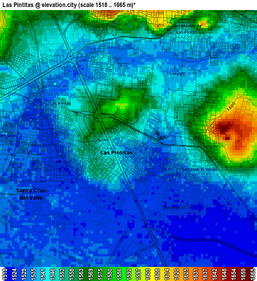
Below is the Elevation map of Las Pintitas, which displays elevation range with different colors. Scale of the first map is from 1518 to 1665 m (4980 to 5463 ft) with average elevation of 1543.7 meters (=5065 ft) [note 1]
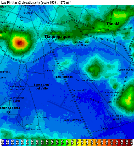
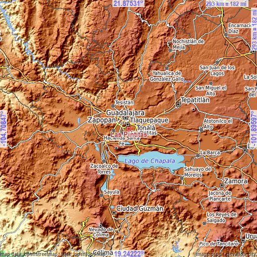
These maps also provides idea of topography and contour of this city, they are displayed at different zoom levels. More info about maps, scale and edge coordinates you can find below images.
| \ | Map #1 | Map #2 | Topo.Map |
| Scale [m] | 1518..1665 m | 1509..1873 m | × |
| Scale [ft] | 4980..5463 ft | 4951..6145 ft | × |
| Average | 1543.7 m = 5065 ft | 1564.2 m = 5132 ft | × |
| Width | 9.15 km = 5.7 mi | 18.3 km = 11.4 mi | 292.8 km = 181.9 mi |
| Height | 9.15 km = 5.7 mi | 18.3 km = 11.4 mi | 292.8 km = 181.9 mi |
| ↑Max Latitude | 20.605579° | 20.646708° | 21.87531° |
| Latitude at center | 20.56444° | 20.56444° | 20.56444° |
| ↓Min Latitude | 20.523289° | 20.482128° | 19.24222° |
| ← Min Longitude | -103.346165° | -103.390111° | -104.70847° |
| Longitude center | -103.30222° | -103.30222° | -103.30222° |
| →Max Longitude | -103.258275° | -103.214329° | -101.89597° |
Nearby cities:
Cities around Las Pintitas sort by population:
• Tlaquepaque elevation 1581 m
8.6 km,  6°
6°
• Las Pintas de Arriba 1548 m
2.4 km,  295°
295°
• El Quince 1525 m
2.9 km,  141°
141°
• Real del Valle (El Paraíso) [Fraccionamiento] 1533 m
7.3 km,  253°
253°
• Valle Dorado Inn 1533 m
7.6 km,  234°
234°
• El Verde 1542 m
2.6 km,  111°
111°
• La Unión del Cuatro 1534 m
7.8 km,  241°
241°
• Altus Bosques 1545 m
7.3 km,  273°
273°
• Hacienda Vieja del Castillo (Castillo Viejo) 1539 m
6.6 km, 114°
• Jardines del Edén 1530 m
7.2 km, 240°
• Colonia Guadalupana 1542 m
8.7 km,  88°
88°
• Paseos del Valle [Fraccionamiento] 1530 m
5.7 km,  214°
214°
Multilingual:
 En español:
Las Pintitas elevación 1541 m.
 En France:
Las Pintitas élévation 1541 m.
 Auf Deutsch:
Las Pintitas höhe über dem Meeresspiegel ist 1541 m.

Sources and notes:
- [note 1] Map square and city borders are not equal. Map elevation data is calculated only from area inside that square.
- [src 1] Elevation data from geonames database provided with same terms of usage.
- [src 2] The elevation map of Las Pintitas is generated using elevation data from NASA's 3 arcsec (90m) resolution SRTM data.
- [src 3] Base (background) map © OpenStreetMap contributors tiles are generated by Geofabrik and OpenTopoMap.
Copyright & License:
This Las Pintitas Elevation Map is licensed under CC BY-SA. You may reuse any part from this page, if you give a proper credit by linking to this URL:
 More info on terms of use page.