El Verde elevation
El Verde (Jalisco, El Salto), Mexico elevation is 1542 meters and El Verde elevation in feet is 5059 ft above sea level [src 1]. El Verde is a populated place (feature code) with elevation that is 228 meters (748 ft) bigger than average city elevation in Mexico.
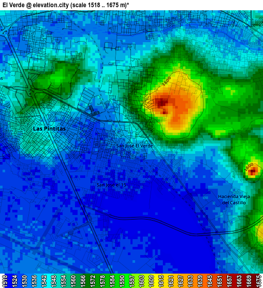
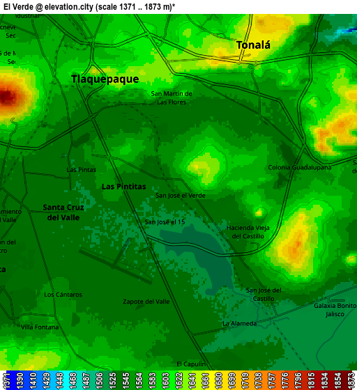
Below is the Elevation map of El Verde, which displays elevation range with different colors. Scale of the first map is from 1518 to 1675 m (4980 to 5495 ft) with average elevation of 1545.3 meters (=5070 ft) [note 1]
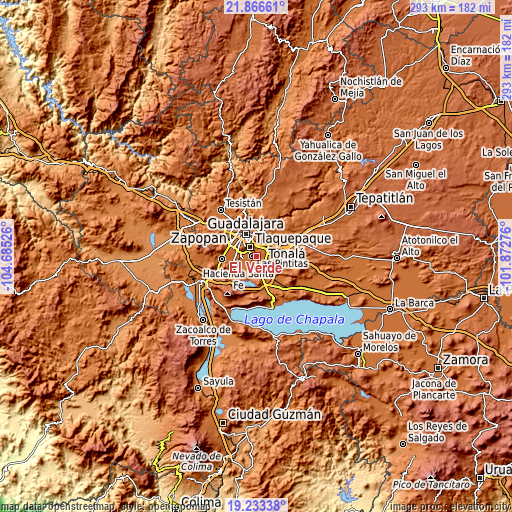
These maps also provides idea of topography and contour of this city, they are displayed at different zoom levels. More info about maps, scale and edge coordinates you can find below images.
| \ | Map #1 | Map #2 | Topo.Map |
| Scale [m] | 1518..1675 m | 1371..1873 m | × |
| Scale [ft] | 4980..5495 ft | 4498..6145 ft | × |
| Average | 1545.3 m = 5070 ft | 1563.3 m = 5129 ft | × |
| Width | 9.15 km = 5.7 mi | 18.3 km = 11.4 mi | 292.8 km = 181.9 mi |
| Height | 9.15 km = 5.7 mi | 18.3 km = 11.4 mi | 292.8 km = 181.9 mi |
| ↑Max Latitude | 20.596812° | 20.637943° | 21.86661° |
| Latitude at center | 20.55567° | 20.55567° | 20.55567° |
| ↓Min Latitude | 20.514517° | 20.473353° | 19.23338° |
| ← Min Longitude | -103.322955° | -103.366901° | -104.68526° |
| Longitude center | -103.27901° | -103.27901° | -103.27901° |
| →Max Longitude | -103.235065° | -103.191119° | -101.87276° |
Nearby cities:
Cities around El Verde sort by population:
• Las Pintitas elevation 1541 m
2.6 km,  291°
291°
• Las Pintas de Arriba 1548 m
5 km, 293°
• El Quince 1525 m
1.4 km,  204°
204°
• San José del Castillo 1548 m
6.3 km,  137°
137°
• Centro de Readaptación Social 1564 m
8.9 km,  90°
90°
• La Alameda 1522 m
7.4 km,  154°
154°
• Capulín 1543 m
8.7 km,  173°
173°
• La Punta 1567 m
7.2 km,  75°
75°
• Hacienda Vieja del Castillo (Castillo Viejo) 1539 m
4 km,  115°
115°
• El Muey 1524 m
8.4 km,  134°
134°
• Colonia Guadalupana 1542 m
6.4 km, 78°
• Paseos del Valle [Fraccionamiento] 1530 m
6.8 km,  236°
236°
Multilingual:
 En español:
El Verde elevación 1542 m.
 En France:
El Verde élévation 1542 m.
 Auf Deutsch:
El Verde höhe über dem Meeresspiegel ist 1542 m.

Sources and notes:
- [note 1] Map square and city borders are not equal. Map elevation data is calculated only from area inside that square.
- [src 1] Elevation data from geonames database provided with same terms of usage.
- [src 2] The elevation map of El Verde is generated using elevation data from NASA's 3 arcsec (90m) resolution SRTM data.
- [src 3] Base (background) map © OpenStreetMap contributors tiles are generated by Geofabrik and OpenTopoMap.
Copyright & License:
This El Verde Elevation Map is licensed under CC BY-SA. You may reuse any part from this page, if you give a proper credit by linking to this URL:
 More info on terms of use page.