Puente Grande elevation
Puente Grande (Jalisco, Tonalá), Mexico elevation is 1475 meters and Puente Grande elevation in feet is 4839 ft above sea level [src 1]. Puente Grande is a populated place (feature code) with elevation that is 161 meters (528 ft) bigger than average city elevation in Mexico.
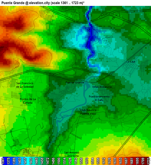
Below is the Elevation map of Puente Grande, which displays elevation range with different colors. Scale of the first map is from 1361 to 1723 m (4465 to 5653 ft) with average elevation of 1514.3 meters (=4968 ft) [note 1]
These maps also provides idea of topography and contour of this city, they are displayed at different zoom levels. More info about maps, scale and edge coordinates you can find below images.
| \ | Map #1 | Map #2 | Topo.Map |
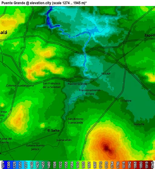
| Scale [m] | 1361..1723 m | 1274..1945 m | × |
| Scale [ft] | 4465..5653 ft | 4180..6381 ft | × |
| Average | 1514.3 m = 4968 ft | 1538.9 m = 5049 ft | × |
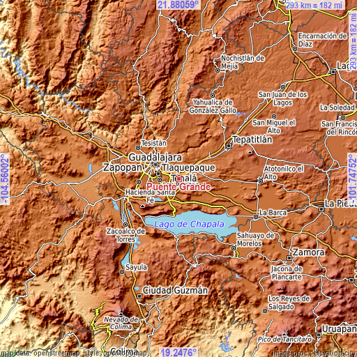
| Width | 9.15 km = 5.7 mi | 18.3 km = 11.4 mi | 292.8 km = 181.9 mi |
| Height | 9.15 km = 5.7 mi | 18.3 km = 11.4 mi | 292.8 km = 181.9 mi |
| ↑Max Latitude | 20.610908° | 20.652035° | 21.88059° |
| Latitude at center | 20.56977° | 20.56977° | 20.56977° |
| ↓Min Latitude | 20.528621° | 20.487461° | 19.2476° |
| ← Min Longitude | -103.197715° | -103.241661° | -104.56002° |
| Longitude center | -103.15377° | -103.15377° | -103.15377° |
| →Max Longitude | -103.109825° | -103.065879° | -101.74752° |
Nearby cities:
Cities around Puente Grande sort by population:
• El Salto elevation 1535 m
6.3 km,  207°
207°
• Centro de Readaptación Social 1564 m
4.5 km,  247°
247°
• Juanacatlán 1529 m
7 km,  194°
194°
• La Punta 1567 m
6 km,  271°
271°
• La Laja 1457 m
3.5 km,  70°
70°
• Cerro Santa Fe 1489 m
8.7 km,  124°
124°
• Paseo Puente Viejo 1552 m
3.8 km, 269°
• Mismaloya (Fraccionamiento Pedregal de Santa Martha) 1567 m
4.5 km,  336°
336°
• Paseo de las Cañadas 1558 m
7.3 km,  321°
321°
• Colonia Guadalupana 1542 m
6.8 km, 267°
• El Salitre 1480 m
5.9 km,  109°
109°
• La Mezquitera 1463 m
4.5 km, 106°
Multilingual:
 En español:
Puente Grande elevación 1475 m.
 En France:
Puente Grande élévation 1475 m.
 Auf Deutsch:
Puente Grande höhe über dem Meeresspiegel ist 1475 m.

Sources and notes:
- [note 1] Map square and city borders are not equal. Map elevation data is calculated only from area inside that square.
- [src 1] Elevation data from geonames database provided with same terms of usage.
- [src 2] The elevation map of Puente Grande is generated using elevation data from NASA's 3 arcsec (90m) resolution SRTM data.
- [src 3] Base (background) map © OpenStreetMap contributors tiles are generated by Geofabrik and OpenTopoMap.
Copyright & License:
This Puente Grande Elevation Map is licensed under CC BY-SA. You may reuse any part from this page, if you give a proper credit by linking to this URL:
 More info on terms of use page.