Juanacatlán elevation
Juanacatlán (Jalisco), Mexico elevation is 1529 meters and Juanacatlán elevation in feet is 5016 ft above sea level [src 1]. Juanacatlán is a seat of a second-order administrative division (feature code) with elevation that is 215 meters (705 ft) bigger than average city elevation in Mexico.
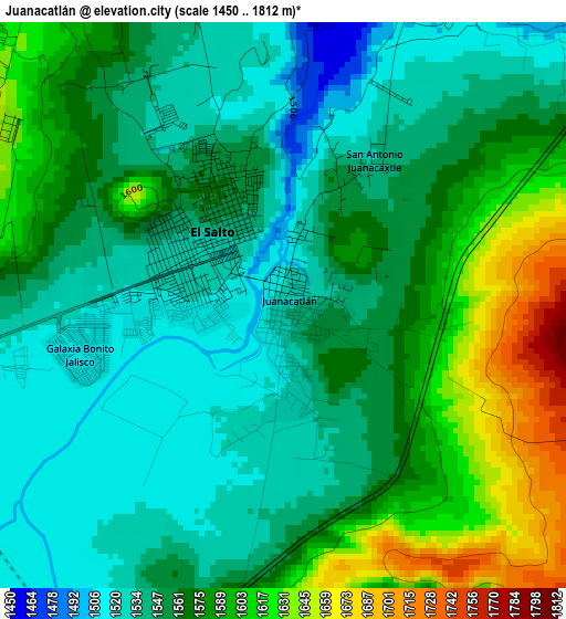
Below is the Elevation map of Juanacatlán, which displays elevation range with different colors. Scale of the first map is from 1450 to 1812 m (4757 to 5945 ft) with average elevation of 1564.9 meters (=5134 ft) [note 1]
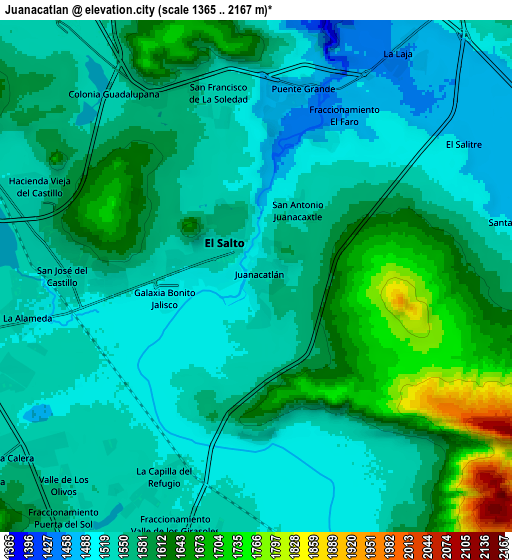
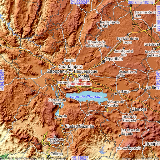
These maps also provides idea of topography and contour of this city, they are displayed at different zoom levels. More info about maps, scale and edge coordinates you can find below images.
| \ | Map #1 | Map #2 | Topo.Map |
| Scale [m] | 1450..1812 m | 1365..2167 m | × |
| Scale [ft] | 4757..5945 ft | 4478..7110 ft | × |
| Average | 1564.9 m = 5134 ft | 1572.3 m = 5158 ft | × |
| Width | 9.15 km = 5.7 mi | 18.31 km = 11.4 mi | 292.9 km = 182 mi |
| Height | 9.15 km = 5.7 mi | 18.31 km = 11.4 mi | 292.9 km = 182 mi |
| ↑Max Latitude | 20.550034° | 20.591178° | 21.82024° |
| Latitude at center | 20.50888° | 20.50888° | 20.50888° |
| ↓Min Latitude | 20.467715° | 20.426538° | 19.1862° |
| ← Min Longitude | -103.214195° | -103.258141° | -104.5765° |
| Longitude center | -103.17025° | -103.17025° | -103.17025° |
| →Max Longitude | -103.126305° | -103.082359° | -101.764° |
Nearby cities:
Cities around Juanacatlán sort by population:
• El Salto elevation 1535 m
1.6 km,  313°
313°
• San José del Castillo 1548 m
7.1 km,  274°
274°
• Centro de Readaptación Social 1564 m
5.6 km,  334°
334°
• Galaxia Bonito Jalisco 1521 m
3.6 km,  263°
263°
• La Alameda 1522 m
8.3 km, 259°
• Puente Grande 1475 m
7 km,  14°
14°
• La Punta 1567 m
8.2 km, 328°
• Paseo Puente Viejo 1552 m
7 km,  342°
342°
• Rinconada la Loma [Fraccionamiento] 1531 m
7.9 km,  219°
219°
• El Muey 1524 m
5.3 km, 262°
• Colonia Guadalupana 1542 m
8.2 km,  321°
321°
• La Mezquitera 1463 m
8.1 km,  47°
47°
Multilingual:
 En español:
Juanacatlán elevación 1529 m.
 En France:
Juanacatlán élévation 1529 m.
 Auf Deutsch:
Juanacatlán höhe über dem Meeresspiegel ist 1529 m.

Sources and notes:
- [note 1] Map square and city borders are not equal. Map elevation data is calculated only from area inside that square.
- [src 1] Elevation data from geonames database provided with same terms of usage.
- [src 2] The elevation map of Juanacatlán is generated using elevation data from NASA's 3 arcsec (90m) resolution SRTM data.
- [src 3] Base (background) map © OpenStreetMap contributors tiles are generated by Geofabrik and OpenTopoMap.
Copyright & License:
This Juanacatlán Elevation Map is licensed under CC BY-SA. You may reuse any part from this page, if you give a proper credit by linking to this URL:
 More info on terms of use page.