San Gabriel elevation
San Gabriel (Jalisco, Cuquío), Mexico elevation is 1892 meters and San Gabriel elevation in feet is 6207 ft above sea level [src 1]. San Gabriel is a populated place (feature code) with elevation that is 578 meters (1896 ft) bigger than average city elevation in Mexico.
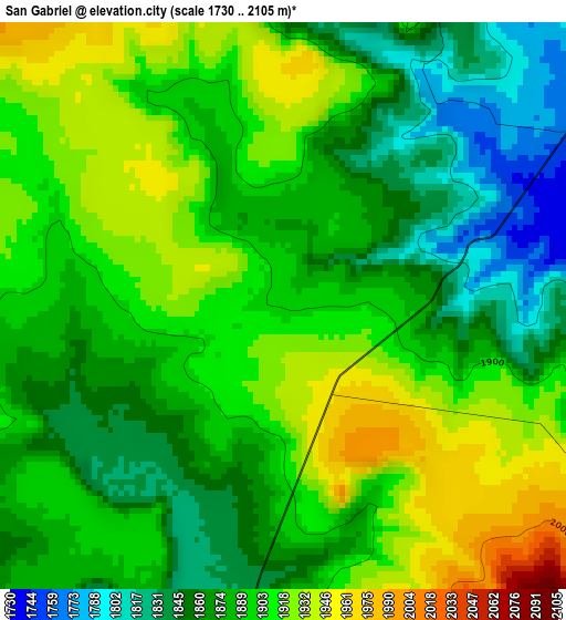
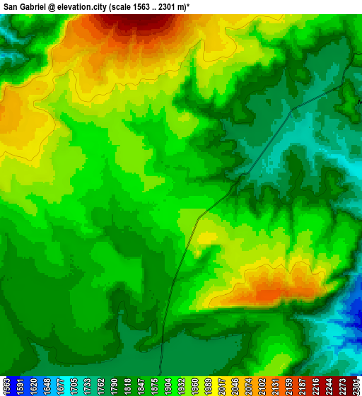
Below is the Elevation map of San Gabriel, which displays elevation range with different colors. Scale of the first map is from 1730 to 2105 m (5676 to 6906 ft) with average elevation of 1889.4 meters (=6199 ft) [note 1]
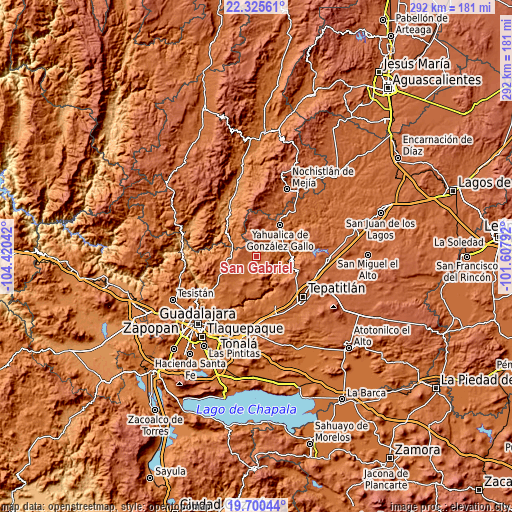
These maps also provides idea of topography and contour of this city, they are displayed at different zoom levels. More info about maps, scale and edge coordinates you can find below images.
| \ | Map #1 | Map #2 | Topo.Map |
| Scale [m] | 1730..2105 m | 1563..2301 m | × |
| Scale [ft] | 5676..6906 ft | 5128..7549 ft | × |
| Average | 1889.4 m = 6199 ft | 1885.8 m = 6187 ft | × |
| Width | 9.12 km = 5.7 mi | 18.24 km = 11.3 mi | 291.9 km = 181.4 mi |
| Height | 9.12 km = 5.7 mi | 18.24 km = 11.3 mi | 291.9 km = 181.4 mi |
| ↑Max Latitude | 21.059816° | 21.10082° | 22.32561° |
| Latitude at center | 21.0188° | 21.0188° | 21.0188° |
| ↓Min Latitude | 20.977773° | 20.936735° | 19.70044° |
| ← Min Longitude | -103.058115° | -103.102061° | -104.42042° |
| Longitude center | -103.01417° | -103.01417° | -103.01417° |
| →Max Longitude | -102.970225° | -102.926279° | -101.60792° |
Nearby cities:
Cities around San Gabriel sort by population:
• Yahualica de González Gallo elevation 1792 m
22.3 km,  36°
36°
• Acatic 1684 m
28.7 km,  157°
157°
• Ixtlahuacán del Río 1638 m
29.1 km,  233°
233°
• Cuquío 1781 m
9.9 km,  188°
188°
• El Zapote 1713 m
24 km,  64°
64°
• Moyahua de Estrada 1175 m
31.7 km,  330°
330°
• Mezcala 1673 m
18.9 km,  112°
112°
• San Antonio de los Vázquez 1693 m
26.2 km,  211°
211°
• Trejos 1637 m
31.4 km,  217°
217°
• Lázaro Cárdenas 1778 m
8.2 km, 185°
• Manalisco 1752 m
10.6 km, 64°
• Palos Altos 1780 m
21.8 km, 221°
Multilingual:
 En español:
San Gabriel elevación 1892 m.
 En France:
San Gabriel élévation 1892 m.
 Auf Deutsch:
San Gabriel höhe über dem Meeresspiegel ist 1892 m.

Sources and notes:
- [note 1] Map square and city borders are not equal. Map elevation data is calculated only from area inside that square.
- [src 1] Elevation data from geonames database provided with same terms of usage.
- [src 2] The elevation map of San Gabriel is generated using elevation data from NASA's 3 arcsec (90m) resolution SRTM data.
- [src 3] Base (background) map © OpenStreetMap contributors tiles are generated by Geofabrik and OpenTopoMap.
Copyright & License:
This San Gabriel Elevation Map is licensed under CC BY-SA. You may reuse any part from this page, if you give a proper credit by linking to this URL:
 More info on terms of use page.