El Zapote elevation
El Zapote (Jalisco, Cañadas de Obregón), Mexico elevation is 1713 meters and El Zapote elevation in feet is 5620 ft above sea level [src 1]. El Zapote is a populated place (feature code) with elevation that is 399 meters (1309 ft) bigger than average city elevation in Mexico.
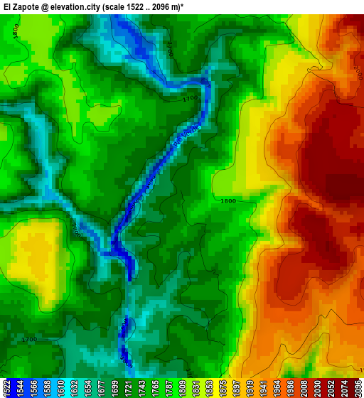
Below is the Elevation map of El Zapote, which displays elevation range with different colors. Scale of the first map is from 1522 to 2096 m (4993 to 6877 ft) with average elevation of 1796.9 meters (=5895 ft) [note 1]
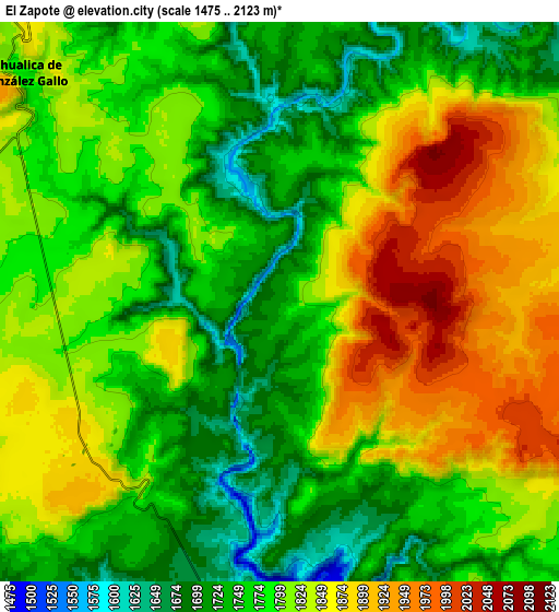
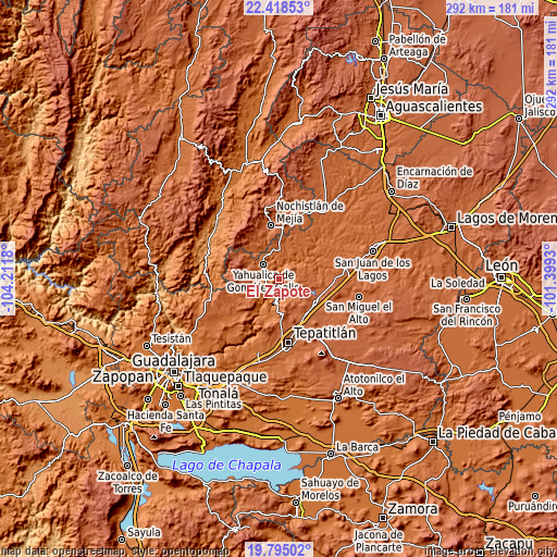
These maps also provides idea of topography and contour of this city, they are displayed at different zoom levels. More info about maps, scale and edge coordinates you can find below images.
| \ | Map #1 | Map #2 | Topo.Map |
| Scale [m] | 1522..2096 m | 1475..2123 m | × |
| Scale [ft] | 4993..6877 ft | 4839..6965 ft | × |
| Average | 1796.9 m = 5895 ft | 1801.4 m = 5910 ft | × |
| Width | 9.12 km = 5.7 mi | 18.23 km = 11.3 mi | 291.7 km = 181.3 mi |
| Height | 9.12 km = 5.7 mi | 18.23 km = 11.3 mi | 291.7 km = 181.3 mi |
| ↑Max Latitude | 21.15356° | 21.194538° | 22.41853° |
| Latitude at center | 21.11257° | 21.11257° | 21.11257° |
| ↓Min Latitude | 21.071569° | 21.030556° | 19.79502° |
| ← Min Longitude | -102.849495° | -102.893441° | -104.2118° |
| Longitude center | -102.80555° | -102.80555° | -102.80555° |
| →Max Longitude | -102.761605° | -102.717659° | -101.3993° |
Nearby cities:
Cities around El Zapote sort by population:
• Nochistlán de Mejía elevation 1875 m
28.3 km,  351°
351°
• Yahualica de González Gallo 1792 m
11.2 km,  311°
311°
• Cuquío 1781 m
30.7 km,  228°
228°
• Valle de Guadalupe 1826 m
22.6 km,  119°
119°
• San Gabriel 1892 m
24 km,  244°
244°
• Pegueros 1888 m
22.8 km,  141°
141°
• Mexticacán 1758 m
17.2 km,  8°
8°
• Cañadas de Obregón 1866 m
12.9 km,  71°
71°
• Mezcala 1673 m
18.3 km,  193°
193°
• Apulco 1795 m
33.2 km,  22°
22°
• Lázaro Cárdenas 1778 m
29.2 km, 230°
• Manalisco 1752 m
13.5 km, 243°
Multilingual:
 En español:
El Zapote elevación 1713 m.
 En France:
El Zapote élévation 1713 m.
 Auf Deutsch:
El Zapote höhe über dem Meeresspiegel ist 1713 m.

Sources and notes:
- [note 1] Map square and city borders are not equal. Map elevation data is calculated only from area inside that square.
- [src 1] Elevation data from geonames database provided with same terms of usage.
- [src 2] The elevation map of El Zapote is generated using elevation data from NASA's 3 arcsec (90m) resolution SRTM data.
- [src 3] Base (background) map © OpenStreetMap contributors tiles are generated by Geofabrik and OpenTopoMap.
Copyright & License:
This El Zapote Elevation Map is licensed under CC BY-SA. You may reuse any part from this page, if you give a proper credit by linking to this URL:
 More info on terms of use page.