Apulco elevation
Apulco (Zacatecas), Mexico elevation is 1795 meters and Apulco elevation in feet is 5889 ft above sea level [src 1]. Apulco is a seat of a second-order administrative division (feature code) with elevation that is 481 meters (1578 ft) bigger than average city elevation in Mexico.
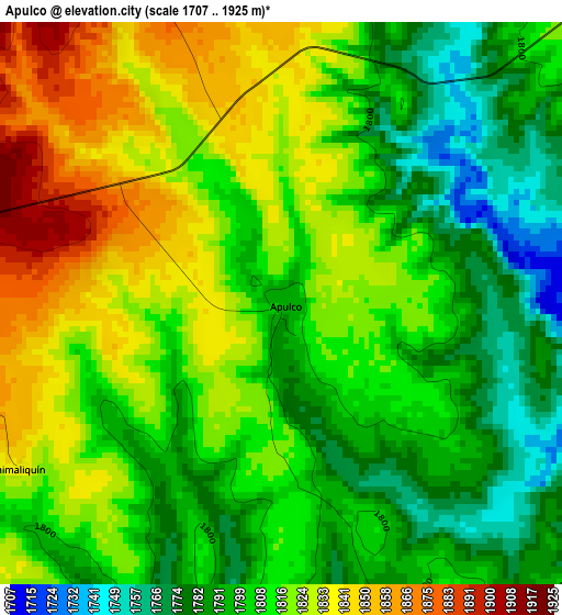
Below is the Elevation map of Apulco, which displays elevation range with different colors. Scale of the first map is from 1707 to 1925 m (5600 to 6316 ft) with average elevation of 1810.8 meters (=5941 ft) [note 1]
These maps also provides idea of topography and contour of this city, they are displayed at different zoom levels. More info about maps, scale and edge coordinates you can find below images.
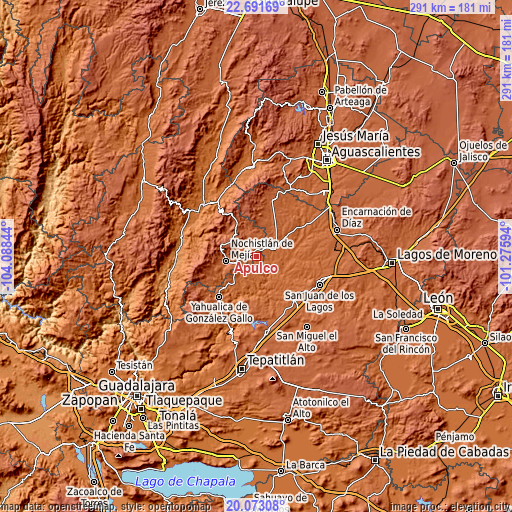
| \ | Map #1 | Topo.Map |
| Scale [m] | 1707..1925 m | × |
| Scale [ft] | 5600..6316 ft | × |
| Average | 1810.8 m = 5941 ft | × |
| Width | 9.1 km = 5.7 mi | 291.2 km = 180.9 mi |
| Height | 9.1 km = 5.7 mi | 291.2 km = 180.9 mi |
| ↑Max Latitude | 21.429153° | 22.69169° |
| Latitude at center | 21.38824° | 21.38824° |
| ↓Min Latitude | 21.347315° | 20.07308° |
| ← Min Longitude | -102.726135° | -104.08844° |
| Longitude center | -102.68219° | -102.68219° |
| →Max Longitude | -102.638245° | -101.27594° |
Nearby cities:
Cities around Apulco sort by population:
• Jalostotitlán elevation 1763 m
33.4 km,  137°
137°
• Teocaltiche 1738 m
12.3 km,  65°
65°
• Nochistlán de Mejía 1875 m
17.2 km,  261°
261°
• Yahualica de González Gallo 1792 m
31.4 km,  222°
222°
• El Zapote 1713 m
33.2 km,  202°
202°
• Mexticacán 1758 m
17 km, 216°
• Cañadas de Obregón 1866 m
26.6 km,  181°
181°
• Mechoacanejo 1862 m
19.1 km,  27°
27°
• Belén del Refugio 1726 m
30 km,  58°
58°
• Tenayuca 1855 m
13 km,  11°
11°
• Tlachichila 2196 m
21.7 km,  330°
330°
• Tepusco 1876 m
26.3 km,  18°
18°
Multilingual:
 En español:
Apulco elevación 1795 m.
 En France:
Apulco élévation 1795 m.


Sources and notes:
- [note 1] Map square and city borders are not equal. Map elevation data is calculated only from area inside that square.
- [src 1] Elevation data from geonames database provided with same terms of usage.
- [src 2] The elevation map of Apulco is generated using elevation data from NASA's 3 arcsec (90m) resolution SRTM data.
- [src 3] Base (background) map © OpenStreetMap contributors tiles are generated by Geofabrik and OpenTopoMap.
Copyright & License:
This Apulco Elevation Map is licensed under CC BY-SA. You may reuse any part from this page, if you give a proper credit by linking to this URL:
 More info on terms of use page.