Belén del Refugio elevation
Belén del Refugio (Jalisco, Teocaltiche), Mexico elevation is 1726 meters and Belén del Refugio elevation in feet is 5663 ft above sea level [src 1]. Belén del Refugio is a populated place (feature code) with elevation that is 412 meters (1352 ft) bigger than average city elevation in Mexico.
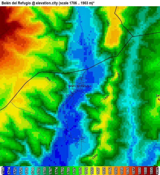
Below is the Elevation map of Belén del Refugio, which displays elevation range with different colors. Scale of the first map is from 1706 to 1903 m (5597 to 6243 ft) with average elevation of 1779.2 meters (=5837 ft) [note 1]
These maps also provides idea of topography and contour of this city, they are displayed at different zoom levels. More info about maps, scale and edge coordinates you can find below images.
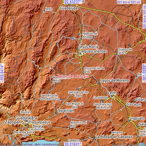
| \ | Map #1 | Topo.Map |
| Scale [m] | 1706..1903 m | × |
| Scale [ft] | 5597..6243 ft | × |
| Average | 1779.2 m = 5837 ft | × |
| Width | 9.09 km = 5.6 mi | 290.9 km = 180.8 mi |
| Height | 9.09 km = 5.6 mi | 290.9 km = 180.8 mi |
| ↑Max Latitude | 21.571103° | 22.83237° |
| Latitude at center | 21.53023° | 21.53023° |
| ↓Min Latitude | 21.489345° | 20.21631° |
| ← Min Longitude | -102.479095° | -103.8414° |
| Longitude center | -102.43515° | -102.43515° |
| →Max Longitude | -102.391205° | -101.0289° |
Nearby cities:
Cities around Belén del Refugio sort by population:
• Encarnación de Díaz elevation 1809 m
20.2 km,  91°
91°
• Teocaltiche 1738 m
17.9 km,  233°
233°
• Villa Hidalgo 1942 m
22.7 km,  315°
315°
• Mechoacanejo 1862 m
16.7 km,  273°
273°
• San Antonio de Peñuelas 1834 m
21.3 km,  40°
40°
• Tenayuca 1855 m
23.2 km,  262°
262°
• Peñuelas (El Cienegal) 1863 m
27 km, 37°
• El Refugio de Peñuelas 1864 m
25.6 km, 36°
• Santa María Transpontina 1830 m
22.4 km,  124°
124°
• Tepusco 1876 m
19.6 km,  298°
298°
• Centro de Arriba 1863 m
23.3 km,  343°
343°
• Santa María de Enmedio 1839 m
25.2 km, 119°
Multilingual:
 En español:
Belén del Refugio elevación 1726 m.
 En France:
Belén del Refugio élévation 1726 m.
 Auf Deutsch:
Belén del Refugio höhe über dem Meeresspiegel ist 1726 m.
 На русском:
Belén del Refugio высота над уровнем моря 1726 м
Sources and notes:
- [note 1] Map square and city borders are not equal. Map elevation data is calculated only from area inside that square.
- [src 1] Elevation data from geonames database provided with same terms of usage.
- [src 2] The elevation map of Belén del Refugio is generated using elevation data from NASA's 3 arcsec (90m) resolution SRTM data.
- [src 3] Base (background) map © OpenStreetMap contributors tiles are generated by Geofabrik and OpenTopoMap.
Copyright & License:
This Belén del Refugio Elevation Map is licensed under CC BY-SA. You may reuse any part from this page, if you give a proper credit by linking to this URL:
 More info on terms of use page.