Tlachichila elevation
Tlachichila (Zacatecas, Nochistlán de Mejía), Mexico elevation is 2196 meters and Tlachichila elevation in feet is 7205 ft above sea level [src 1]. Tlachichila is a populated place (feature code) with elevation that is 882 meters (2894 ft) bigger than average city elevation in Mexico.
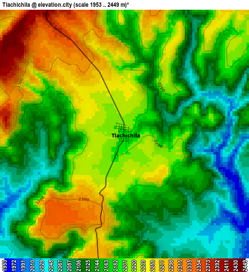
Below is the Elevation map of Tlachichila, which displays elevation range with different colors. Scale of the first map is from 1953 to 2449 m (6407 to 8035 ft) with average elevation of 2179.6 meters (=7151 ft) [note 1]
These maps also provides idea of topography and contour of this city, they are displayed at different zoom levels. More info about maps, scale and edge coordinates you can find below images.
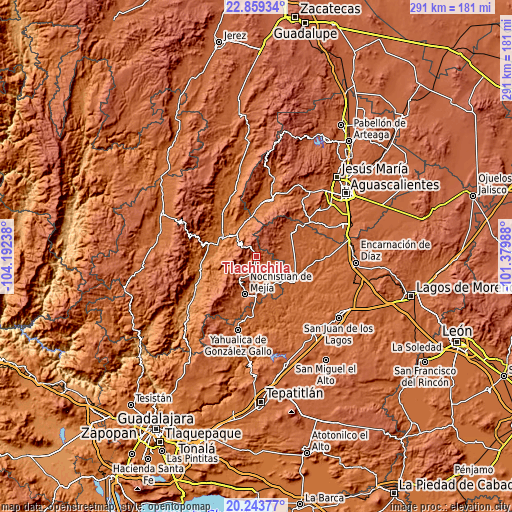
| \ | Map #1 | Topo.Map |
| Scale [m] | 1953..2449 m | × |
| Scale [ft] | 6407..8035 ft | × |
| Average | 2179.6 m = 7151 ft | × |
| Width | 9.09 km = 5.6 mi | 290.8 km = 180.7 mi |
| Height | 9.09 km = 5.6 mi | 290.8 km = 180.7 mi |
| ↑Max Latitude | 21.598316° | 22.85934° |
| Latitude at center | 21.55745° | 21.55745° |
| ↓Min Latitude | 21.516573° | 20.24377° |
| ← Min Longitude | -102.830075° | -104.19238° |
| Longitude center | -102.78613° | -102.78613° |
| →Max Longitude | -102.742185° | -101.37988° |
Nearby cities:
Cities around Tlachichila sort by population:
• Teocaltiche elevation 1738 m
25.8 km,  122°
122°
• Nochistlán de Mejía 1875 m
22.3 km,  196°
196°
• Villa Hidalgo 1942 m
24.4 km,  57°
57°
• Jalpa 1387 m
21.7 km,  293°
293°
• Mechoacanejo 1862 m
19.8 km,  95°
95°
• Valle Huejúcar (Fraccionamiento Popular) [Fraccionamiento] 1655 m
30.7 km,  6°
6°
• Tenayuca 1855 m
14.6 km,  114°
114°
• Apulco 1795 m
21.7 km,  150°
150°
• Tepusco 1876 m
20 km,  72°
72°
• Mesa Grande 1774 m
28.3 km, 13°
• Jaltiche de Arriba 1598 m
24.2 km,  359°
359°
• Crucero Las Pilas 1619 m
30.1 km, 5°
Multilingual:
 En español:
Tlachichila elevación 2196 m.
 En France:
Tlachichila élévation 2196 m.
 Auf Deutsch:
Tlachichila höhe über dem Meeresspiegel ist 2196 m.

Sources and notes:
- [note 1] Map square and city borders are not equal. Map elevation data is calculated only from area inside that square.
- [src 1] Elevation data from geonames database provided with same terms of usage.
- [src 2] The elevation map of Tlachichila is generated using elevation data from NASA's 3 arcsec (90m) resolution SRTM data.
- [src 3] Base (background) map © OpenStreetMap contributors tiles are generated by Geofabrik and OpenTopoMap.
Copyright & License:
This Tlachichila Elevation Map is licensed under CC BY-SA. You may reuse any part from this page, if you give a proper credit by linking to this URL:
 More info on terms of use page.