Jalpa elevation
Jalpa (Zacatecas), Mexico elevation is 1387 meters and Jalpa elevation in feet is 4551 ft above sea level [src 1]. Jalpa is a seat of a second-order administrative division (feature code) with elevation that is 73 meters (240 ft) bigger than average city elevation in Mexico.
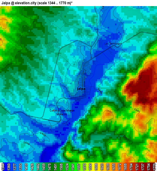
Below is the Elevation map of Jalpa, which displays elevation range with different colors. Scale of the first map is from 1344 to 1770 m (4409 to 5807 ft) with average elevation of 1464.6 meters (=4805 ft) [note 1]
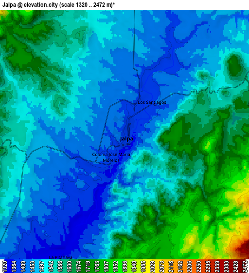
These maps also provides idea of topography and contour of this city, they are displayed at different zoom levels. More info about maps, scale and edge coordinates you can find below images.
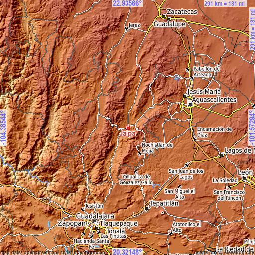
| \ | Map #1 | Map #2 | Topo.Map |
| Scale [m] | 1344..1770 m | 1320..2472 m | × |
| Scale [ft] | 4409..5807 ft | 4331..8110 ft | × |
| Average | 1464.6 m = 4805 ft | 1554.5 m = 5100 ft | × |
| Width | 9.08 km = 5.6 mi | 18.17 km = 11.3 mi | 290.7 km = 180.6 mi |
| Height | 9.08 km = 5.6 mi | 18.17 km = 11.3 mi | 290.7 km = 180.6 mi |
| ↑Max Latitude | 21.675324° | 21.716156° | 22.93566° |
| Latitude at center | 21.63448° | 21.63448° | 21.63448° |
| ↓Min Latitude | 21.593625° | 21.552758° | 20.32148° |
| ← Min Longitude | -103.023135° | -103.067081° | -104.38544° |
| Longitude center | -102.97919° | -102.97919° | -102.97919° |
| →Max Longitude | -102.935245° | -102.891299° | -101.57294° |
Nearby cities:
Cities around Jalpa sort by population:
• Nochistlán de Mejía elevation 1875 m
33 km,  155°
155°
• Tabasco 1520 m
26.4 km,  15°
15°
• Juchipila 1248 m
28.9 km,  209°
209°
• Apozol 1272 m
21.7 km, 212°
• Valle Huejúcar (Fraccionamiento Popular) [Fraccionamiento] 1655 m
32.2 km,  47°
47°
• Huanusco 1506 m
15.5 km,  2°
2°
• Tlachichila 2196 m
21.7 km,  113°
113°
• Mesa Grande 1774 m
32.7 km, 54°
• Jaltiche de Arriba 1598 m
25.2 km, 51°
• Crucero Las Pilas 1619 m
31.1 km, 46°
• Cicacalco 1702 m
35.6 km,  284°
284°
• El Plateado de Joaquín Amaro 2372 m
35.5 km,  340°
340°
Multilingual:
 En español:
Jalpa elevación 1387 m.
 En France:
Jalpa élévation 1387 m.


Sources and notes:
- [note 1] Map square and city borders are not equal. Map elevation data is calculated only from area inside that square.
- [src 1] Elevation data from geonames database provided with same terms of usage.
- [src 2] The elevation map of Jalpa is generated using elevation data from NASA's 3 arcsec (90m) resolution SRTM data.
- [src 3] Base (background) map © OpenStreetMap contributors tiles are generated by Geofabrik and OpenTopoMap.
Copyright & License:
This Jalpa Elevation Map is licensed under CC BY-SA. You may reuse any part from this page, if you give a proper credit by linking to this URL:
 More info on terms of use page.