Tabasco elevation
Tabasco (Zacatecas), Mexico elevation is 1520 meters and Tabasco elevation in feet is 4987 ft above sea level [src 1]. Tabasco is a seat of a second-order administrative division (feature code) with elevation that is 206 meters (676 ft) bigger than average city elevation in Mexico.
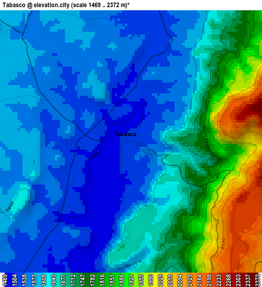
Below is the Elevation map of Tabasco, which displays elevation range with different colors. Scale of the first map is from 1469 to 2372 m (4820 to 7782 ft) with average elevation of 1662.5 meters (=5454 ft) [note 1]
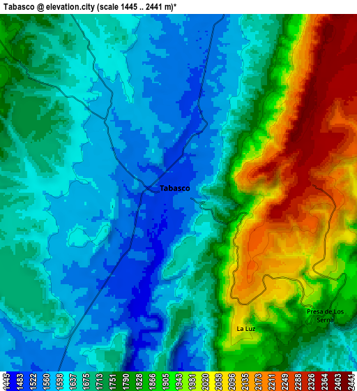
These maps also provides idea of topography and contour of this city, they are displayed at different zoom levels. More info about maps, scale and edge coordinates you can find below images.
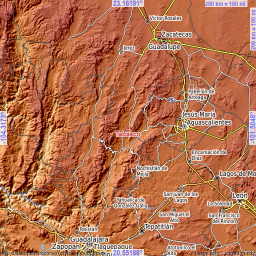
| \ | Map #1 | Map #2 | Topo.Map |
| Scale [m] | 1469..2372 m | 1445..2441 m | × |
| Scale [ft] | 4820..7782 ft | 4741..8009 ft | × |
| Average | 1662.5 m = 5454 ft | 1759.7 m = 5773 ft | × |
| Width | 9.07 km = 5.6 mi | 18.14 km = 11.3 mi | 290.2 km = 180.3 mi |
| Height | 9.07 km = 5.6 mi | 18.14 km = 11.3 mi | 290.2 km = 180.3 mi |
| ↑Max Latitude | 21.903639° | 21.944406° | 23.16191° |
| Latitude at center | 21.86286° | 21.86286° | 21.86286° |
| ↓Min Latitude | 21.82207° | 21.781267° | 20.55188° |
| ← Min Longitude | -102.954995° | -102.998941° | -104.3173° |
| Longitude center | -102.91105° | -102.91105° | -102.91105° |
| →Max Longitude | -102.867105° | -102.823159° | -101.5048° |
Nearby cities:
Cities around Tabasco sort by population:
• Calvillo elevation 1629 m
20 km,  95°
95°
• Ojocaliente 1681 m
24.2 km,  87°
87°
• El Cuervero (Cuerveros) 1678 m
23.4 km, 90°
• Valle Huejúcar (Fraccionamiento Popular) [Fraccionamiento] 1655 m
17 km, 102°
• La Labor 1747 m
24.8 km,  63°
63°
• Huanusco 1506 m
11.8 km,  212°
212°
• San Tadeo 1703 m
22.6 km,  73°
73°
• La Panadera 1656 m
22 km, 89°
• Mesa Grande 1774 m
20.6 km,  108°
108°
• Jaltiche de Arriba 1598 m
16 km,  127°
127°
• Crucero Las Pilas 1619 m
16.1 km, 104°
• El Plateado de Joaquín Amaro 2372 m
20.4 km,  293°
293°
Multilingual:
 En español:
Tabasco elevación 1520 m.
 En France:
Tabasco élévation 1520 m.
 Auf Deutsch:
Tabasco höhe über dem Meeresspiegel ist 1520 m.

Sources and notes:
- [note 1] Map square and city borders are not equal. Map elevation data is calculated only from area inside that square.
- [src 1] Elevation data from geonames database provided with same terms of usage.
- [src 2] The elevation map of Tabasco is generated using elevation data from NASA's 3 arcsec (90m) resolution SRTM data.
- [src 3] Base (background) map © OpenStreetMap contributors tiles are generated by Geofabrik and OpenTopoMap.
Copyright & License:
This Tabasco Elevation Map is licensed under CC BY-SA. You may reuse any part from this page, if you give a proper credit by linking to this URL:
 More info on terms of use page.