Juchipila elevation
Juchipila (Zacatecas), Mexico elevation is 1248 meters and Juchipila elevation in feet is 4094 ft above sea level [src 1]. Juchipila is a seat of a second-order administrative division (feature code) with elevation that is 66 meters (217 ft) smaller than average city elevation in Mexico.
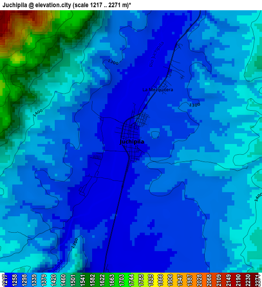
Below is the Elevation map of Juchipila, which displays elevation range with different colors. Scale of the first map is from 1217 to 2271 m (3993 to 7451 ft) with average elevation of 1352.4 meters (=4437 ft) [note 1]
These maps also provides idea of topography and contour of this city, they are displayed at different zoom levels. More info about maps, scale and edge coordinates you can find below images.
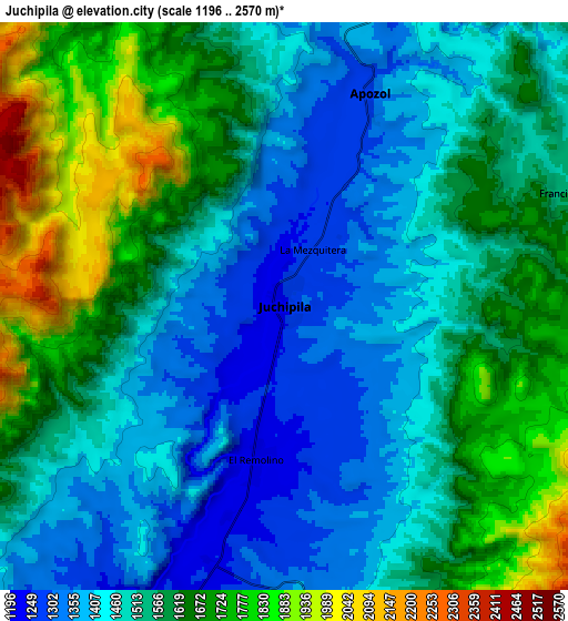
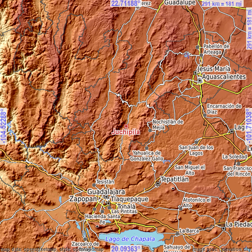
| \ | Map #1 | Map #2 | Topo.Map |
| Scale [m] | 1217..2271 m | 1196..2570 m | × |
| Scale [ft] | 3993..7451 ft | 3924..8432 ft | × |
| Average | 1352.4 m = 4437 ft | 1546.3 m = 5073 ft | × |
| Width | 9.1 km = 5.7 mi | 18.2 km = 11.3 mi | 291.1 km = 180.9 mi |
| Height | 9.1 km = 5.7 mi | 18.2 km = 11.3 mi | 291.1 km = 180.9 mi |
| ↑Max Latitude | 21.449527° | 21.490423° | 22.71188° |
| Latitude at center | 21.40862° | 21.40862° | 21.40862° |
| ↓Min Latitude | 21.367701° | 21.326771° | 20.09363° |
| ← Min Longitude | -103.160575° | -103.204521° | -104.52288° |
| Longitude center | -103.11663° | -103.11663° | -103.11663° |
| →Max Longitude | -103.072685° | -103.028739° | -101.71038° |
Nearby cities:
Cities around Juchipila sort by population:
• Nochistlán de Mejía elevation 1875 m
28.5 km,  99°
99°
• Jalpa 1387 m
28.9 km,  29°
29°
• Yahualica de González Gallo 1792 m
34.9 km,  136°
136°
• Tepechitlán 1719 m
36.3 km,  323°
323°
• Mexticacán 1758 m
38.3 km,  114°
114°
• Teúl de González Ortega 1912 m
36.2 km,  279°
279°
• Apozol 1272 m
7.3 km,  21°
21°
• Moyahua de Estrada 1175 m
16.6 km,  197°
197°
• Santa María de la Paz 1920 m
32.3 km,  290°
290°
• Tlachichila 2196 m
38 km,  64°
64°
• Mezquital del Oro 1214 m
33.3 km,  230°
230°
• Cicacalco 1702 m
39.7 km,  329°
329°
Multilingual:
 En español:
Juchipila elevación 1248 m.
 En France:
Juchipila élévation 1248 m.
 Auf Deutsch:
Juchipila höhe über dem Meeresspiegel ist 1248 m.

Sources and notes:
- [note 1] Map square and city borders are not equal. Map elevation data is calculated only from area inside that square.
- [src 1] Elevation data from geonames database provided with same terms of usage.
- [src 2] The elevation map of Juchipila is generated using elevation data from NASA's 3 arcsec (90m) resolution SRTM data.
- [src 3] Base (background) map © OpenStreetMap contributors tiles are generated by Geofabrik and OpenTopoMap.
Copyright & License:
This Juchipila Elevation Map is licensed under CC BY-SA. You may reuse any part from this page, if you give a proper credit by linking to this URL:
 More info on terms of use page.