Mezquital del Oro elevation
Mezquital del Oro (Zacatecas), Mexico elevation is 1214 meters and Mezquital del Oro elevation in feet is 3983 ft above sea level [src 1]. Mezquital del Oro is a populated place (feature code) with elevation that is 100 meters (328 ft) smaller than average city elevation in Mexico.
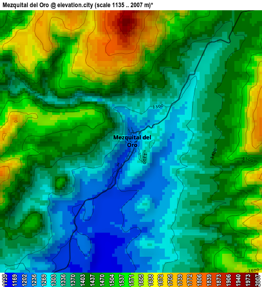
Below is the Elevation map of Mezquital del Oro, which displays elevation range with different colors. Scale of the first map is from 1135 to 2007 m (3724 to 6585 ft) with average elevation of 1423.9 meters (=4672 ft) [note 1]
These maps also provides idea of topography and contour of this city, they are displayed at different zoom levels. More info about maps, scale and edge coordinates you can find below images.
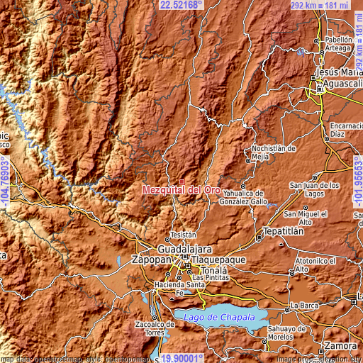
| \ | Map #1 | Topo.Map |
| Scale [m] | 1135..2007 m | × |
| Scale [ft] | 3724..6585 ft | × |
| Average | 1423.9 m = 4672 ft | × |
| Width | 9.11 km = 5.7 mi | 291.5 km = 181.1 mi |
| Height | 9.11 km = 5.7 mi | 291.5 km = 181.1 mi |
| ↑Max Latitude | 21.257631° | 22.52168° |
| Latitude at center | 21.21667° | 21.21667° |
| ↓Min Latitude | 21.175698° | 19.90001° |
| ← Min Longitude | -103.406725° | -104.76903° |
| Longitude center | -103.36278° | -103.36278° |
| →Max Longitude | -103.318835° | -101.95653° |
Nearby cities:
Cities around Mezquital del Oro sort by population:
• Ixtlahuacán del Río elevation 1638 m
41.2 km,  162°
162°
• Juchipila 1248 m
33.3 km,  50°
50°
• San Gabriel 1892 m
42.3 km,  121°
121°
• Teúl de González Ortega 1912 m
29.3 km,  339°
339°
• Florencia 2176 m
37.6 km,  328°
328°
• Apozol 1272 m
39.8 km, 45°
• El Salvador 1834 m
42.8 km,  238°
238°
• Trinidad García de la Cadena 1737 m
10.7 km,  266°
266°
• Moyahua de Estrada 1175 m
21.1 km,  74°
74°
• Santa María de la Paz 1920 m
33.2 km,  351°
351°
• Palos Altos 1780 m
44.1 km,  150°
150°
• San Cristóbal de la Barranca 826 m
20.3 km,  199°
199°
Multilingual:
 En español:
Mezquital del Oro elevación 1214 m.
 En France:
Mezquital del Oro élévation 1214 m.
 Auf Deutsch:
Mezquital del Oro höhe über dem Meeresspiegel ist 1214 m.
 На русском:
Mezquital del Oro высота над уровнем моря 1214 м
Sources and notes:
- [note 1] Map square and city borders are not equal. Map elevation data is calculated only from area inside that square.
- [src 1] Elevation data from geonames database provided with same terms of usage.
- [src 2] The elevation map of Mezquital del Oro is generated using elevation data from NASA's 3 arcsec (90m) resolution SRTM data.
- [src 3] Base (background) map © OpenStreetMap contributors tiles are generated by Geofabrik and OpenTopoMap.
Copyright & License:
This Mezquital del Oro Elevation Map is licensed under CC BY-SA. You may reuse any part from this page, if you give a proper credit by linking to this URL:
 More info on terms of use page.