Cicacalco elevation
Cicacalco (Zacatecas, Tlaltenango de Sánchez Román), Mexico elevation is 1702 meters and Cicacalco elevation in feet is 5584 ft above sea level [src 1]. Cicacalco is a populated place (feature code) with elevation that is 388 meters (1273 ft) bigger than average city elevation in Mexico.
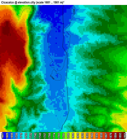
Below is the Elevation map of Cicacalco, which displays elevation range with different colors. Scale of the first map is from 1681 to 1901 m (5515 to 6237 ft) with average elevation of 1756.6 meters (=5763 ft) [note 1]
These maps also provides idea of topography and contour of this city, they are displayed at different zoom levels. More info about maps, scale and edge coordinates you can find below images.
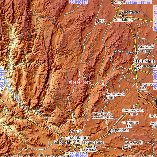
| \ | Map #1 | Topo.Map |
| Scale [m] | 1681..1901 m | × |
| Scale [ft] | 5515..6237 ft | × |
| Average | 1756.6 m = 5763 ft | × |
| Width | 9.08 km = 5.6 mi | 290.5 km = 180.5 mi |
| Height | 9.08 km = 5.6 mi | 290.5 km = 180.5 mi |
| ↑Max Latitude | 21.756571° | 23.01617° |
| Latitude at center | 21.71575° | 21.71575° |
| ↓Min Latitude | 21.674918° | 20.40346° |
| ← Min Longitude | -103.356805° | -104.71911° |
| Longitude center | -103.31286° | -103.31286° |
| →Max Longitude | -103.268915° | -101.90661° |
Nearby cities:
Cities around Cicacalco sort by population:
• Tlaltenango de Sánchez Román elevation 1691 m
7.5 km,  7°
7°
• Jalpa 1387 m
35.6 km,  104°
104°
• Tepechitlán 1719 m
5.2 km,  195°
195°
• Teúl de González Ortega 1912 m
32 km,  208°
208°
• Florencia 2176 m
34.3 km,  226°
226°
• Apozol 1272 m
35.7 km,  140°
140°
• Huanusco 1506 m
35.7 km,  79°
79°
• Santa María de la Paz 1920 m
24.7 km, 203°
• Momax 1650 m
23 km,  359°
359°
• Atolinga 2136 m
18.7 km,  302°
302°
• Totatiche 1761 m
27.2 km,  330°
330°
• El Plateado de Joaquín Amaro 2372 m
33.4 km,  42°
42°
Multilingual:
 En español:
Cicacalco elevación 1702 m.
 En France:
Cicacalco élévation 1702 m.
 Auf Deutsch:
Cicacalco höhe über dem Meeresspiegel ist 1702 m.

Sources and notes:
- [note 1] Map square and city borders are not equal. Map elevation data is calculated only from area inside that square.
- [src 1] Elevation data from geonames database provided with same terms of usage.
- [src 2] The elevation map of Cicacalco is generated using elevation data from NASA's 3 arcsec (90m) resolution SRTM data.
- [src 3] Base (background) map © OpenStreetMap contributors tiles are generated by Geofabrik and OpenTopoMap.
Copyright & License:
This Cicacalco Elevation Map is licensed under CC BY-SA. You may reuse any part from this page, if you give a proper credit by linking to this URL:
 More info on terms of use page.