Atolinga elevation
Atolinga (Zacatecas), Mexico elevation is 2136 meters and Atolinga elevation in feet is 7008 ft above sea level [src 1]. Atolinga is a seat of a second-order administrative division (feature code) with elevation that is 822 meters (2697 ft) bigger than average city elevation in Mexico.
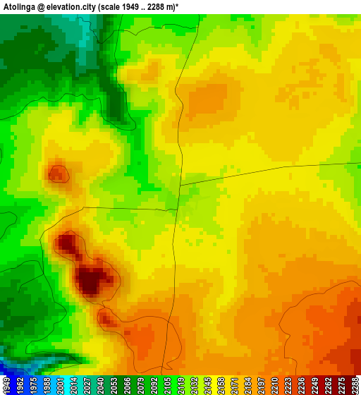
Below is the Elevation map of Atolinga, which displays elevation range with different colors. Scale of the first map is from 1949 to 2288 m (6394 to 7507 ft) with average elevation of 2148.6 meters (=7049 ft) [note 1]
These maps also provides idea of topography and contour of this city, they are displayed at different zoom levels. More info about maps, scale and edge coordinates you can find below images.
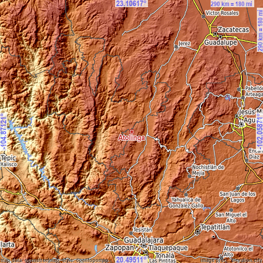
| \ | Map #1 | Topo.Map |
| Scale [m] | 1949..2288 m | × |
| Scale [ft] | 6394..7507 ft | × |
| Average | 2148.6 m = 7049 ft | × |
| Width | 9.07 km = 5.6 mi | 290.3 km = 180.4 mi |
| Height | 9.07 km = 5.6 mi | 290.3 km = 180.4 mi |
| ↑Max Latitude | 21.847385° | 23.10617° |
| Latitude at center | 21.80659° | 21.80659° |
| ↓Min Latitude | 21.765783° | 20.49511° |
| ← Min Longitude | -103.508905° | -104.87121° |
| Longitude center | -103.46496° | -103.46496° |
| →Max Longitude | -103.421015° | -102.05871° |
Nearby cities:
Cities around Atolinga sort by population:
• Tlaltenango de Sánchez Román elevation 1691 m
16.9 km,  99°
99°
• Tepechitlán 1719 m
20.8 km,  136°
136°
• Villa Guerrero 1774 m
23.8 km,  325°
325°
• Teúl de González Ortega 1912 m
38.2 km,  179°
179°
• Florencia 2176 m
34.9 km,  195°
195°
• San Martín de Bolaños 813 m
38.5 km,  249°
249°
• Santa María de la Paz 1920 m
33.3 km,  169°
169°
• Momax 1650 m
20.3 km,  50°
50°
• Temastián (La Cantera) 1870 m
20 km,  341°
341°
• Totatiche 1761 m
13.7 km,  9°
9°
• Cicacalco 1702 m
18.7 km,  122°
122°
• Chimaltitán 857 m
32.7 km,  264°
264°
Multilingual:
 En español:
Atolinga elevación 2136 m.
 En France:
Atolinga élévation 2136 m.
 Auf Deutsch:
Atolinga höhe über dem Meeresspiegel ist 2136 m.

Sources and notes:
- [note 1] Map square and city borders are not equal. Map elevation data is calculated only from area inside that square.
- [src 1] Elevation data from geonames database provided with same terms of usage.
- [src 2] The elevation map of Atolinga is generated using elevation data from NASA's 3 arcsec (90m) resolution SRTM data.
- [src 3] Base (background) map © OpenStreetMap contributors tiles are generated by Geofabrik and OpenTopoMap.
Copyright & License:
This Atolinga Elevation Map is licensed under CC BY-SA. You may reuse any part from this page, if you give a proper credit by linking to this URL:
 More info on terms of use page.