Villa Guerrero elevation
Villa Guerrero (Jalisco), Mexico elevation is 1774 meters and Villa Guerrero elevation in feet is 5820 ft above sea level [src 1]. Villa Guerrero is a seat of a second-order administrative division (feature code) with elevation that is 460 meters (1509 ft) bigger than average city elevation in Mexico.
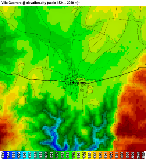
Below is the Elevation map of Villa Guerrero, which displays elevation range with different colors. Scale of the first map is from 1524 to 2040 m (5000 to 6693 ft) with average elevation of 1792.2 meters (=5880 ft) [note 1]
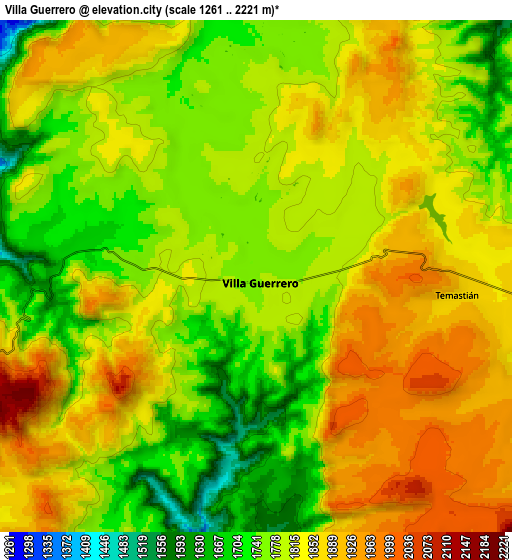
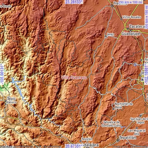
These maps also provides idea of topography and contour of this city, they are displayed at different zoom levels. More info about maps, scale and edge coordinates you can find below images.
| \ | Map #1 | Map #2 | Topo.Map |
| Scale [m] | 1524..2040 m | 1261..2221 m | × |
| Scale [ft] | 5000..6693 ft | 4137..7287 ft | × |
| Average | 1792.2 m = 5880 ft | 1811.2 m = 5942 ft | × |
| Width | 9.06 km = 5.6 mi | 18.12 km = 11.3 mi | 290 km = 180.2 mi |
| Height | 9.06 km = 5.6 mi | 18.12 km = 11.3 mi | 290 km = 180.2 mi |
| ↑Max Latitude | 22.024154° | 22.064887° | 23.28133° |
| Latitude at center | 21.98341° | 21.98341° | 21.98341° |
| ↓Min Latitude | 21.942654° | 21.901886° | 20.67351° |
| ← Min Longitude | -103.639005° | -103.682951° | -105.00131° |
| Longitude center | -103.59506° | -103.59506° | -103.59506° |
| →Max Longitude | -103.551115° | -103.507169° | -102.18881° |
Nearby cities:
Cities around Villa Guerrero sort by population:
• Tlaltenango de Sánchez Román elevation 1691 m
37.5 km,  126°
126°
• Colotlán 1666 m
36.7 km,  66°
66°
• Monte Escobedo 2208 m
35.7 km,  4°
4°
• San Martín de Bolaños 813 m
40.3 km,  213°
213°
• Momax 1650 m
29.9 km,  103°
103°
• Atolinga 2136 m
23.8 km,  145°
145°
• Temastián (La Cantera) 1870 m
7.3 km, 95°
• Totatiche 1761 m
16.7 km,  111°
111°
• Las Golondrinas [Fraccionamiento] 1696 m
37.7 km, 68°
• Cicacalco 1702 m
41.6 km,  135°
135°
• Santa María de los Ángeles 1704 m
43.6 km,  61°
61°
• Chimaltitán 857 m
29.7 km,  220°
220°
Multilingual:
 En español:
Villa Guerrero elevación 1774 m.
 En France:
Villa Guerrero élévation 1774 m.
 Auf Deutsch:
Villa Guerrero höhe über dem Meeresspiegel ist 1774 m.

Sources and notes:
- [note 1] Map square and city borders are not equal. Map elevation data is calculated only from area inside that square.
- [src 1] Elevation data from geonames database provided with same terms of usage.
- [src 2] The elevation map of Villa Guerrero is generated using elevation data from NASA's 3 arcsec (90m) resolution SRTM data.
- [src 3] Base (background) map © OpenStreetMap contributors tiles are generated by Geofabrik and OpenTopoMap.
Copyright & License:
This Villa Guerrero Elevation Map is licensed under CC BY-SA. You may reuse any part from this page, if you give a proper credit by linking to this URL:
 More info on terms of use page.