Nochistlán de Mejía elevation
Nochistlán de Mejía (Zacatecas), Mexico elevation is 1875 meters and Nochistlán de Mejía elevation in feet is 6152 ft above sea level [src 1]. Nochistlán de Mejía is a seat of a second-order administrative division (feature code) with elevation that is 561 meters (1841 ft) bigger than average city elevation in Mexico.
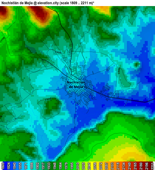
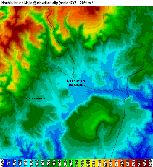
Below is the Elevation map of Nochistlán de Mejía, which displays elevation range with different colors. Scale of the first map is from 1809 to 2211 m (5935 to 7254 ft) with average elevation of 1916.4 meters (=6287 ft) [note 1]
These maps also provides idea of topography and contour of this city, they are displayed at different zoom levels. More info about maps, scale and edge coordinates you can find below images.
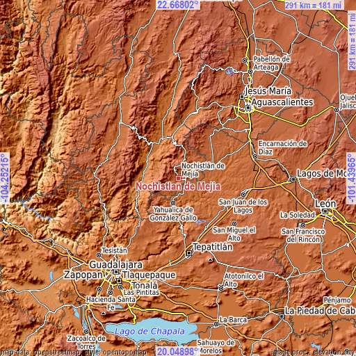
| \ | Map #1 | Map #2 | Topo.Map |
| Scale [m] | 1809..2211 m | 1747..2461 m | × |
| Scale [ft] | 5935..7254 ft | 5732..8074 ft | × |
| Average | 1916.4 m = 6287 ft | 1987 m = 6519 ft | × |
| Width | 9.1 km = 5.7 mi | 18.2 km = 11.3 mi | 291.2 km = 180.9 mi |
| Height | 9.1 km = 5.7 mi | 18.2 km = 11.3 mi | 291.2 km = 180.9 mi |
| ↑Max Latitude | 21.40527° | 21.446178° | 22.66802° |
| Latitude at center | 21.36435° | 21.36435° | 21.36435° |
| ↓Min Latitude | 21.323419° | 21.282476° | 20.04898° |
| ← Min Longitude | -102.889845° | -102.933791° | -104.25215° |
| Longitude center | -102.8459° | -102.8459° | -102.8459° |
| →Max Longitude | -102.801955° | -102.758009° | -101.43965° |
Nearby cities:
Cities around Nochistlán de Mejía sort by population:
• Teocaltiche elevation 1738 m
29.2 km,  74°
74°
• Jalpa 1387 m
33 km,  335°
335°
• Yahualica de González Gallo 1792 m
20.9 km,  191°
191°
• Juchipila 1248 m
28.5 km,  279°
279°
• El Zapote 1713 m
28.3 km,  171°
171°
• Mexticacán 1758 m
13 km,  148°
148°
• Apozol 1272 m
27.9 km,  294°
294°
• Cañadas de Obregón 1866 m
29 km, 145°
• Mechoacanejo 1862 m
32.4 km,  52°
52°
• Tenayuca 1855 m
24.8 km, 51°
• Apulco 1795 m
17.2 km,  81°
81°
• Tlachichila 2196 m
22.3 km,  16°
16°
Multilingual:
 En español:
Nochistlán de Mejía elevación 1875 m.
 En France:
Nochistlán de Mejía élévation 1875 m.
 Auf Deutsch:
Nochistlán de Mejía höhe über dem Meeresspiegel ist 1875 m.
 На русском:
Nochistlán de Mejía высота над уровнем моря 1875 м
Sources and notes:
- [note 1] Map square and city borders are not equal. Map elevation data is calculated only from area inside that square.
- [src 1] Elevation data from geonames database provided with same terms of usage.
- [src 2] The elevation map of Nochistlán de Mejía is generated using elevation data from NASA's 3 arcsec (90m) resolution SRTM data.
- [src 3] Base (background) map © OpenStreetMap contributors tiles are generated by Geofabrik and OpenTopoMap.
Copyright & License:
This Nochistlán de Mejía Elevation Map is licensed under CC BY-SA. You may reuse any part from this page, if you give a proper credit by linking to this URL:
 More info on terms of use page.