Acatic elevation
Acatic (Jalisco), Mexico elevation is 1684 meters and Acatic elevation in feet is 5525 ft above sea level [src 1]. Acatic is a seat of a second-order administrative division (feature code) with elevation that is 370 meters (1214 ft) bigger than average city elevation in Mexico.
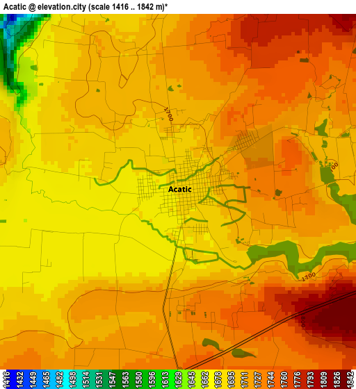
Below is the Elevation map of Acatic, which displays elevation range with different colors. Scale of the first map is from 1416 to 1842 m (4646 to 6043 ft) with average elevation of 1708.1 meters (=5604 ft) [note 1]
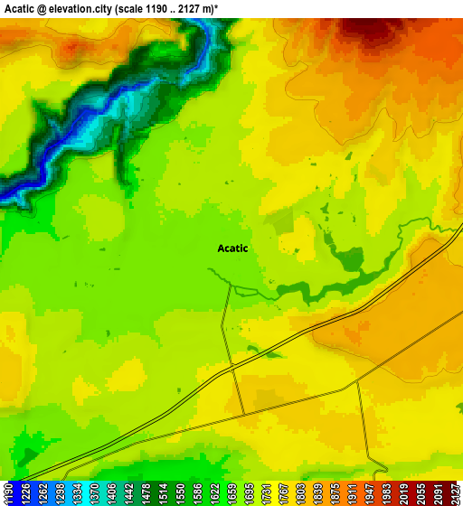
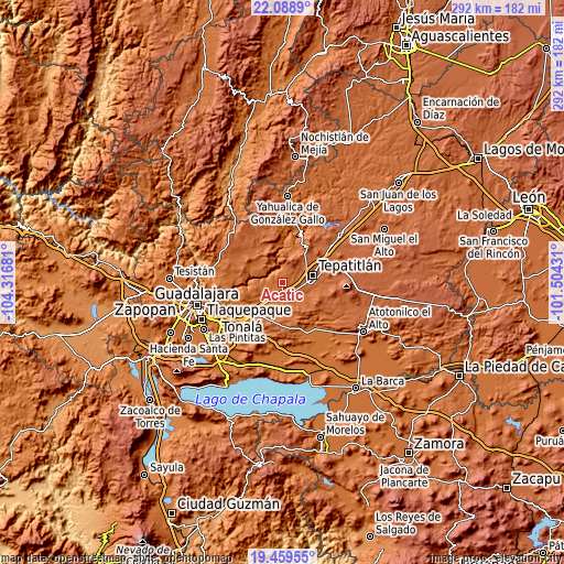
These maps also provides idea of topography and contour of this city, they are displayed at different zoom levels. More info about maps, scale and edge coordinates you can find below images.
| \ | Map #1 | Map #2 | Topo.Map |
| Scale [m] | 1416..1842 m | 1190..2127 m | × |
| Scale [ft] | 4646..6043 ft | 3904..6978 ft | × |
| Average | 1708.1 m = 5604 ft | 1719.9 m = 5643 ft | × |
| Width | 9.14 km = 5.7 mi | 18.27 km = 11.4 mi | 292.4 km = 181.7 mi |
| Height | 9.14 km = 5.7 mi | 18.27 km = 11.4 mi | 292.4 km = 181.7 mi |
| ↑Max Latitude | 20.821031° | 20.862101° | 22.0889° |
| Latitude at center | 20.77995° | 20.77995° | 20.77995° |
| ↓Min Latitude | 20.738858° | 20.697754° | 19.45955° |
| ← Min Longitude | -102.954505° | -102.998451° | -104.31681° |
| Longitude center | -102.91056° | -102.91056° | -102.91056° |
| →Max Longitude | -102.866615° | -102.822669° | -101.50431° |
Nearby cities:
Cities around Acatic sort by population:
• Tepatitlán de Morelos elevation 1825 m
15.8 km,  74°
74°
• Zapotlanejo 1524 m
23.9 km,  223°
223°
• Cuquío 1781 m
20.7 km,  323°
323°
• Capilla de Milpillas 1823 m
14.8 km,  151°
151°
• El Refugio 1777 m
6.1 km,  167°
167°
• Mezcala 1673 m
20.4 km,  19°
19°
• San Antonio de los Vázquez 1693 m
24.9 km,  279°
279°
• Tierras Coloradas 1767 m
7.7 km,  137°
137°
• Lázaro Cárdenas 1778 m
21.8 km,  327°
327°
• San José de las Flores 1722 m
15.7 km,  201°
201°
• San Joaquín Zorrillos 1677 m
20.8 km,  211°
211°
• La Purísima 1625 m
15.3 km,  235°
235°
Multilingual:
 En español:
Acatic elevación 1684 m.
 En France:
Acatic élévation 1684 m.


Sources and notes:
- [note 1] Map square and city borders are not equal. Map elevation data is calculated only from area inside that square.
- [src 1] Elevation data from geonames database provided with same terms of usage.
- [src 2] The elevation map of Acatic is generated using elevation data from NASA's 3 arcsec (90m) resolution SRTM data.
- [src 3] Base (background) map © OpenStreetMap contributors tiles are generated by Geofabrik and OpenTopoMap.
Copyright & License:
This Acatic Elevation Map is licensed under CC BY-SA. You may reuse any part from this page, if you give a proper credit by linking to this URL:
 More info on terms of use page.