Zapotlanejo elevation
Zapotlanejo (Jalisco), Mexico elevation is 1524 meters and Zapotlanejo elevation in feet is 5000 ft above sea level [src 1]. Zapotlanejo is a seat of a second-order administrative division (feature code) with elevation that is 210 meters (689 ft) bigger than average city elevation in Mexico.
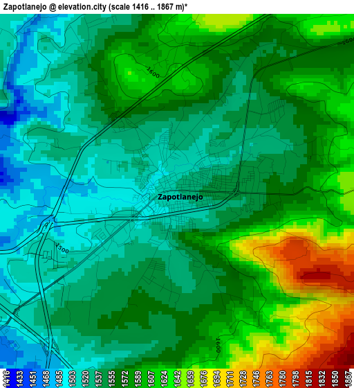
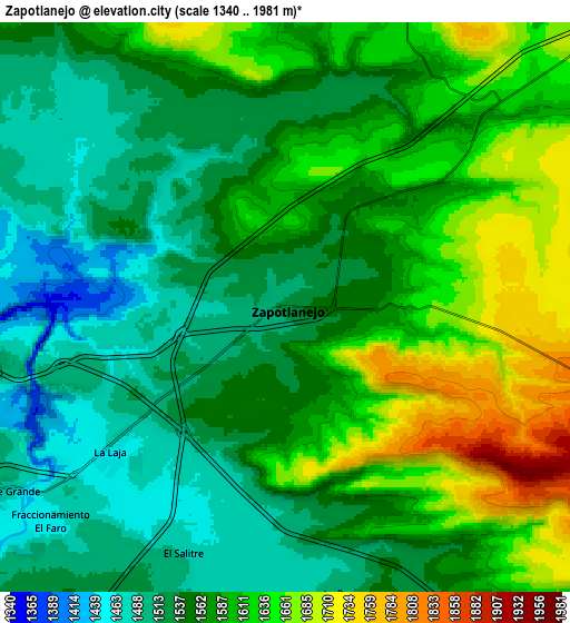
Below is the Elevation map of Zapotlanejo, which displays elevation range with different colors. Scale of the first map is from 1416 to 1867 m (4646 to 6125 ft) with average elevation of 1563.7 meters (=5130 ft) [note 1]
These maps also provides idea of topography and contour of this city, they are displayed at different zoom levels. More info about maps, scale and edge coordinates you can find below images.
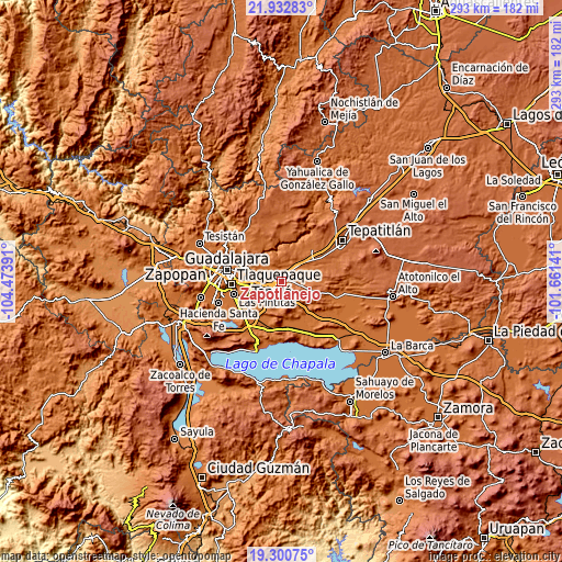
| \ | Map #1 | Map #2 | Topo.Map |
| Scale [m] | 1416..1867 m | 1340..1981 m | × |
| Scale [ft] | 4646..6125 ft | 4396..6499 ft | × |
| Average | 1563.7 m = 5130 ft | 1574.5 m = 5166 ft | × |
| Width | 9.15 km = 5.7 mi | 18.29 km = 11.4 mi | 292.7 km = 181.9 mi |
| Height | 9.15 km = 5.7 mi | 18.29 km = 11.4 mi | 292.7 km = 181.9 mi |
| ↑Max Latitude | 20.663604° | 20.704716° | 21.93283° |
| Latitude at center | 20.62248° | 20.62248° | 20.62248° |
| ↓Min Latitude | 20.581345° | 20.540199° | 19.30075° |
| ← Min Longitude | -103.111605° | -103.155551° | -104.47391° |
| Longitude center | -103.06766° | -103.06766° | -103.06766° |
| →Max Longitude | -103.023715° | -102.979769° | -101.66141° |
Nearby cities:
Cities around Zapotlanejo sort by population:
• Puente Grande elevation 1475 m
10.7 km,  236°
236°
• La Laja 1457 m
7.4 km,  230°
230°
• Cerro Santa Fe 1489 m
10.9 km,  189°
189°
• Mismaloya (Fraccionamiento Pedregal de Santa Martha) 1567 m
10.9 km,  260°
260°
• Paseo de las Cañadas 1558 m
13.5 km,  269°
269°
• Matatlán 1563 m
13 km,  318°
318°
• San José de las Flores 1722 m
11 km,  74°
74°
• El Salitre 1480 m
8.5 km,  203°
203°
• La Mezquitera 1463 m
8.5 km,  213°
213°
• La Paz 1499 m
9.3 km,  170°
170°
• San Joaquín Zorrillos 1677 m
5.4 km,  92°
92°
• La Purísima 1625 m
9.6 km,  22°
22°
Multilingual:
 En español:
Zapotlanejo elevación 1524 m.
 En France:
Zapotlanejo élévation 1524 m.
 Auf Deutsch:
Zapotlanejo höhe über dem Meeresspiegel ist 1524 m.

Sources and notes:
- [note 1] Map square and city borders are not equal. Map elevation data is calculated only from area inside that square.
- [src 1] Elevation data from geonames database provided with same terms of usage.
- [src 2] The elevation map of Zapotlanejo is generated using elevation data from NASA's 3 arcsec (90m) resolution SRTM data.
- [src 3] Base (background) map © OpenStreetMap contributors tiles are generated by Geofabrik and OpenTopoMap.
Copyright & License:
This Zapotlanejo Elevation Map is licensed under CC BY-SA. You may reuse any part from this page, if you give a proper credit by linking to this URL:
 More info on terms of use page.