Tepetzitzintla elevation
Tepetzitzintla (Puebla, Huatlatlauca), Mexico elevation is 1591 meters and Tepetzitzintla elevation in feet is 5220 ft above sea level [src 1]. Tepetzitzintla is a populated place (feature code) with elevation that is 277 meters (909 ft) bigger than average city elevation in Mexico.
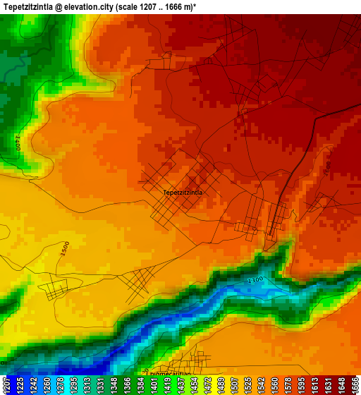
Below is the Elevation map of Tepetzitzintla, which displays elevation range with different colors. Scale of the first map is from 1207 to 1666 m (3960 to 5466 ft) with average elevation of 1525.1 meters (=5004 ft) [note 1]
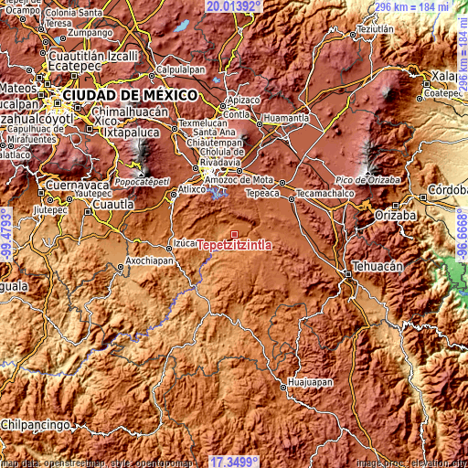
These maps also provides idea of topography and contour of this city, they are displayed at different zoom levels. More info about maps, scale and edge coordinates you can find below images.
| \ | Map #1 | Topo.Map |
| Scale [m] | 1207..1666 m | × |
| Scale [ft] | 3960..5466 ft | × |
| Average | 1525.1 m = 5004 ft | × |
| Width | 9.26 km = 5.8 mi | 296.2 km = 184 mi |
| Height | 9.26 km = 5.8 mi | 296.2 km = 184 mi |
| ↑Max Latitude | 18.728773° | 20.01392° |
| Latitude at center | 18.68715° | 18.68715° |
| ↓Min Latitude | 18.645516° | 17.3499° |
| ← Min Longitude | -98.116995° | -99.4793° |
| Longitude center | -98.07305° | -98.07305° |
| →Max Longitude | -98.029105° | -96.6668° |
Nearby cities:
Cities around Tepetzitzintla sort by population:
• Tepexi de Rodríguez elevation 1726 m
19.5 km,  127°
127°
• Santo Domingo Huehuetlán 1360 m
11.2 km,  301°
301°
• Coatzingo 1186 m
13.4 km,  231°
231°
• San Antonio Juárez 2081 m
14.8 km,  36°
36°
• San Miguel Atlapulco 1691 m
17.4 km,  312°
312°
• Chigmecatitlán 1524 m
4.5 km,  178°
178°
• Tzicatlacoyan 2015 m
17.3 km,  8°
8°
• Zacapala 1326 m
10.4 km, 175°
• Tejaluca 1367 m
19.5 km,  253°
253°
• Santa Catarina Tlaltempan 1493 m
8 km,  185°
185°
• San Juan Atzompa 1652 m
8.2 km, 38°
• Huatlatlauca 1580 m
2.5 km,  104°
104°
Multilingual:
 En español:
Tepetzitzintla elevación 1591 m.
 En France:
Tepetzitzintla élévation 1591 m.
 Auf Deutsch:
Tepetzitzintla höhe über dem Meeresspiegel ist 1591 m.

Sources and notes:
- [note 1] Map square and city borders are not equal. Map elevation data is calculated only from area inside that square.
- [src 1] Elevation data from geonames database provided with same terms of usage.
- [src 2] The elevation map of Tepetzitzintla is generated using elevation data from NASA's 3 arcsec (90m) resolution SRTM data.
- [src 3] Base (background) map © OpenStreetMap contributors tiles are generated by Geofabrik and OpenTopoMap.
Copyright & License:
This Tepetzitzintla Elevation Map is licensed under CC BY-SA. You may reuse any part from this page, if you give a proper credit by linking to this URL:
 More info on terms of use page.