Coatzingo elevation
Coatzingo (Puebla), Mexico elevation is 1186 meters and Coatzingo elevation in feet is 3891 ft above sea level [src 1]. Coatzingo is a seat of a second-order administrative division (feature code) with elevation that is 128 meters (420 ft) smaller than average city elevation in Mexico.
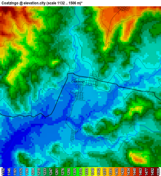
Below is the Elevation map of Coatzingo, which displays elevation range with different colors. Scale of the first map is from 1132 to 1506 m (3714 to 4941 ft) with average elevation of 1239.9 meters (=4068 ft) [note 1]
These maps also provides idea of topography and contour of this city, they are displayed at different zoom levels. More info about maps, scale and edge coordinates you can find below images.
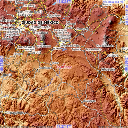
| \ | Map #1 | Topo.Map |
| Scale [m] | 1132..1506 m | × |
| Scale [ft] | 3714..4941 ft | × |
| Average | 1239.9 m = 4068 ft | × |
| Width | 9.26 km = 5.8 mi | 296.3 km = 184.1 mi |
| Height | 9.26 km = 5.8 mi | 296.4 km = 184.2 mi |
| ↑Max Latitude | 18.653632° | 19.93937° |
| Latitude at center | 18.61199° | 18.61199° |
| ↓Min Latitude | 18.570338° | 17.27417° |
| ← Min Longitude | -98.216615° | -99.57892° |
| Longitude center | -98.17267° | -98.17267° |
| →Max Longitude | -98.128725° | -96.76642° |
Nearby cities:
Cities around Coatzingo sort by population:
• Teopantlán elevation 1427 m
14.7 km,  319°
319°
• Santo Domingo Huehuetlán 1360 m
14.2 km,  3°
3°
• Tepetzitzintla 1591 m
13.4 km,  51°
51°
• Xochiltepec 1346 m
18.6 km,  283°
283°
• San Pedro Cuayuca 1226 m
14.5 km,  184°
184°
• Chigmecatitlán 1524 m
11.3 km,  70°
70°
• Zacapala 1326 m
11.4 km,  99°
99°
• Tejaluca 1367 m
8.6 km,  288°
288°
• Ahuatlán 1286 m
9.9 km,  243°
243°
• Santa Catarina Tlaltempan 1493 m
9.7 km,  87°
87°
• Huatlatlauca 1580 m
15 km,  59°
59°
• Totoltepec 1359 m
18.9 km, 283°
Multilingual:
 En español:
Coatzingo elevación 1186 m.
 En France:
Coatzingo élévation 1186 m.
 Auf Deutsch:
Coatzingo höhe über dem Meeresspiegel ist 1186 m.

Sources and notes:
- [note 1] Map square and city borders are not equal. Map elevation data is calculated only from area inside that square.
- [src 1] Elevation data from geonames database provided with same terms of usage.
- [src 2] The elevation map of Coatzingo is generated using elevation data from NASA's 3 arcsec (90m) resolution SRTM data.
- [src 3] Base (background) map © OpenStreetMap contributors tiles are generated by Geofabrik and OpenTopoMap.
Copyright & License:
This Coatzingo Elevation Map is licensed under CC BY-SA. You may reuse any part from this page, if you give a proper credit by linking to this URL:
 More info on terms of use page.