San Miguel Atlapulco elevation
San Miguel Atlapulco (Puebla, Huehuetlán el Grande), Mexico elevation is 1691 meters and San Miguel Atlapulco elevation in feet is 5548 ft above sea level [src 1]. San Miguel Atlapulco is a populated place (feature code) with elevation that is 377 meters (1237 ft) bigger than average city elevation in Mexico.
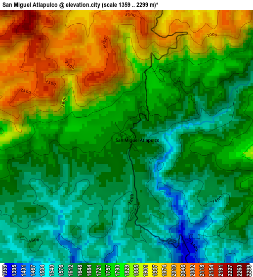
Below is the Elevation map of San Miguel Atlapulco, which displays elevation range with different colors. Scale of the first map is from 1359 to 2299 m (4459 to 7543 ft) with average elevation of 1748.1 meters (=5735 ft) [note 1]
These maps also provides idea of topography and contour of this city, they are displayed at different zoom levels. More info about maps, scale and edge coordinates you can find below images.
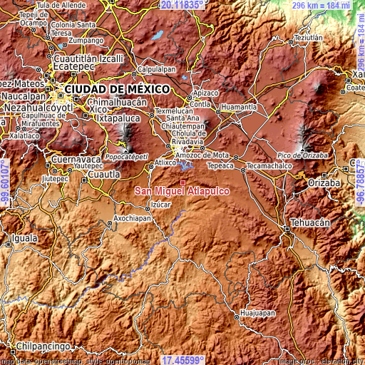
| \ | Map #1 | Topo.Map |
| Scale [m] | 1359..2299 m | × |
| Scale [ft] | 4459..7543 ft | × |
| Average | 1748.1 m = 5735 ft | × |
| Width | 9.25 km = 5.7 mi | 296 km = 183.9 mi |
| Height | 9.25 km = 5.7 mi | 296 km = 183.9 mi |
| ↑Max Latitude | 18.834028° | 20.11835° |
| Latitude at center | 18.79243° | 18.79243° |
| ↓Min Latitude | 18.750822° | 17.45599° |
| ← Min Longitude | -98.238765° | -99.60107° |
| Longitude center | -98.19482° | -98.19482° |
| →Max Longitude | -98.150875° | -96.78857° |
Nearby cities:
Cities around San Miguel Atlapulco sort by population:
• San Andrés Azumiatla elevation 2142 m
13.8 km,  333°
333°
• San Pedro Zacachimalpa 2151 m
17.2 km,  13°
13°
• Teopantlán 1427 m
11.5 km,  218°
218°
• Santo Domingo Huehuetlán 1360 m
6.7 km,  151°
151°
• Los Ángeles Tetela 2116 m
11.2 km,  15°
15°
• Tepetzitzintla 1591 m
17.4 km,  132°
132°
• Santa María Guadalupe Tecola 2078 m
12.7 km,  359°
359°
• Tzicatlacoyan 2015 m
16.3 km,  70°
70°
• Buenavista Tetela 2074 m
14.3 km, 7°
• Tejaluca 1367 m
18.3 km,  198°
198°
• El Capulo (La Quebradora) 2078 m
19.1 km,  335°
335°
• San Juan Atzompa 1652 m
18.7 km,  106°
106°
Multilingual:
 En español:
San Miguel Atlapulco elevación 1691 m.
 En France:
San Miguel Atlapulco élévation 1691 m.
 Auf Deutsch:
San Miguel Atlapulco höhe über dem Meeresspiegel ist 1691 m.
 На русском:
San Miguel Atlapulco высота над уровнем моря 1691 м
Sources and notes:
- [note 1] Map square and city borders are not equal. Map elevation data is calculated only from area inside that square.
- [src 1] Elevation data from geonames database provided with same terms of usage.
- [src 2] The elevation map of San Miguel Atlapulco is generated using elevation data from NASA's 3 arcsec (90m) resolution SRTM data.
- [src 3] Base (background) map © OpenStreetMap contributors tiles are generated by Geofabrik and OpenTopoMap.
Copyright & License:
This San Miguel Atlapulco Elevation Map is licensed under CC BY-SA. You may reuse any part from this page, if you give a proper credit by linking to this URL:
 More info on terms of use page.