Tzicatlacoyan elevation
Tzicatlacoyan (Puebla), Mexico elevation is 2015 meters and Tzicatlacoyan elevation in feet is 6611 ft above sea level [src 1]. Tzicatlacoyan is a populated place (feature code) with elevation that is 701 meters (2300 ft) bigger than average city elevation in Mexico.
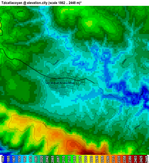
Below is the Elevation map of Tzicatlacoyan, which displays elevation range with different colors. Scale of the first map is from 1862 to 2448 m (6109 to 8031 ft) with average elevation of 2048.9 meters (=6722 ft) [note 1]
These maps also provides idea of topography and contour of this city, they are displayed at different zoom levels. More info about maps, scale and edge coordinates you can find below images.
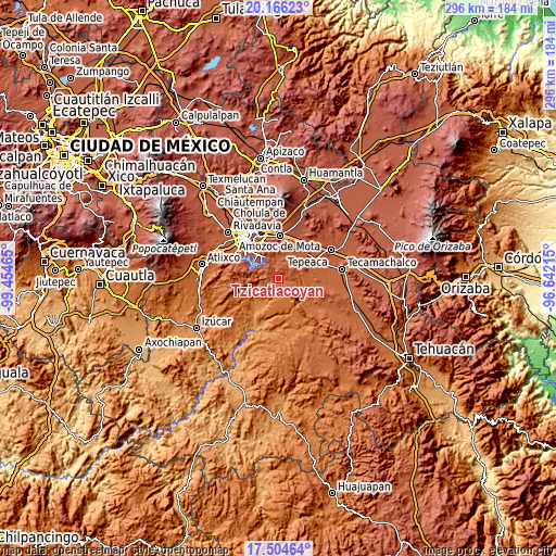
| \ | Map #1 | Topo.Map |
| Scale [m] | 1862..2448 m | × |
| Scale [ft] | 6109..8031 ft | × |
| Average | 2048.9 m = 6722 ft | × |
| Width | 9.25 km = 5.7 mi | 295.9 km = 183.9 mi |
| Height | 9.25 km = 5.7 mi | 296 km = 183.9 mi |
| ↑Max Latitude | 18.882296° | 20.16623° |
| Latitude at center | 18.84071° | 18.84071° |
| ↓Min Latitude | 18.799114° | 17.50464° |
| ← Min Longitude | -98.092345° | -99.45465° |
| Longitude center | -98.0484° | -98.0484° |
| →Max Longitude | -98.004455° | -96.64215° |
Nearby cities:
Cities around Tzicatlacoyan sort by population:
• Atoyatempan elevation 1952 m
14.4 km,  99°
99°
• Tecali 2187 m
10.5 km,  50°
50°
• Ahuatepec 2013 m
13.9 km,  81°
81°
• San Pedro Zacachimalpa 2151 m
16 km,  315°
315°
• San Jerónimo Almoloya 2153 m
11.9 km,  19°
19°
• Cuautinchán 2156 m
13.1 km, 15°
• Los Ángeles Tetela 2116 m
13.6 km,  293°
293°
• San Antonio Juárez 2081 m
8.1 km,  130°
130°
• Concepción Cuautla 2089 m
7.3 km,  66°
66°
• La Trinidad Tianguismanalco 2156 m
6.2 km, 15°
• San Buenaventura 2224 m
14.6 km,  62°
62°
• San Juan Atzompa 1652 m
10.9 km,  166°
166°
Multilingual:
 En español:
San Juan elevación 2015 m.
 En France:
Tzicatlacoyan élévation 2015 m.
 Auf Deutsch:
Tzicatlacoyan höhe über dem Meeresspiegel ist 2015 m.

Sources and notes:
- [note 1] Map square and city borders are not equal. Map elevation data is calculated only from area inside that square.
- [src 1] Elevation data from geonames database provided with same terms of usage.
- [src 2] The elevation map of Tzicatlacoyan is generated using elevation data from NASA's 3 arcsec (90m) resolution SRTM data.
- [src 3] Base (background) map © OpenStreetMap contributors tiles are generated by Geofabrik and OpenTopoMap.
Copyright & License:
This Tzicatlacoyan Elevation Map is licensed under CC BY-SA. You may reuse any part from this page, if you give a proper credit by linking to this URL:
 More info on terms of use page.