Atoyatempan elevation
Atoyatempan (Puebla), Mexico elevation is 1952 meters and Atoyatempan elevation in feet is 6404 ft above sea level [src 1]. Atoyatempan is a seat of a second-order administrative division (feature code) with elevation that is 638 meters (2093 ft) bigger than average city elevation in Mexico.
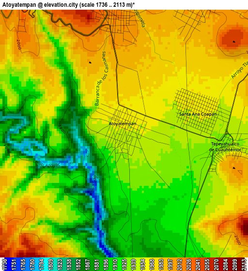
Below is the Elevation map of Atoyatempan, which displays elevation range with different colors. Scale of the first map is from 1736 to 2113 m (5696 to 6932 ft) with average elevation of 1945.8 meters (=6384 ft) [note 1]
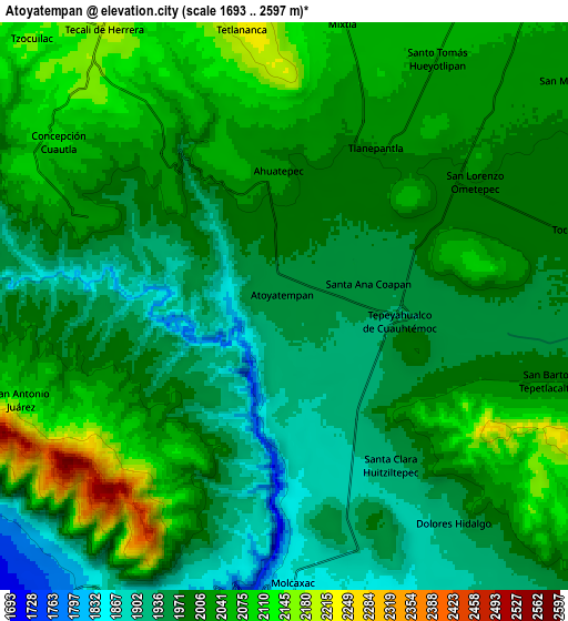
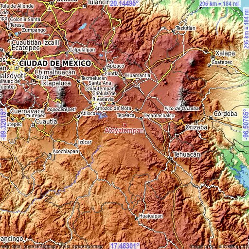
These maps also provides idea of topography and contour of this city, they are displayed at different zoom levels. More info about maps, scale and edge coordinates you can find below images.
| \ | Map #1 | Map #2 | Topo.Map |
| Scale [m] | 1736..2113 m | 1693..2597 m | × |
| Scale [ft] | 5696..6932 ft | 5554..8520 ft | × |
| Average | 1945.8 m = 6384 ft | 2002.5 m = 6570 ft | × |
| Width | 9.25 km = 5.7 mi | 18.5 km = 11.5 mi | 296 km = 183.9 mi |
| Height | 9.25 km = 5.7 mi | 18.5 km = 11.5 mi | 296 km = 183.9 mi |
| ↑Max Latitude | 18.860841° | 18.902421° | 20.14495° |
| Latitude at center | 18.81925° | 18.81925° | 18.81925° |
| ↓Min Latitude | 18.777649° | 18.736037° | 17.48301° |
| ← Min Longitude | -97.957845° | -98.001791° | -99.32015° |
| Longitude center | -97.9139° | -97.9139° | -97.9139° |
| →Max Longitude | -97.869955° | -97.826009° | -96.50765° |
Nearby cities:
Cities around Atoyatempan sort by population:
• Hueyotlipan elevation 2040 m
9.5 km,  32°
32°
• Tlanepantla 2004 m
5.6 km, 30°
• Ahuatepec 2013 m
4.4 km,  354°
354°
• Ometepec 1994 m
7.5 km,  58°
58°
• Santa Clara Huitziltepec 1919 m
6.6 km,  148°
148°
• San Antonio Juárez 2081 m
8.5 km,  250°
250°
• Concepción Cuautla 2089 m
9.2 km,  305°
305°
• Santa Ana Coapan 1961 m
2.7 km, 60°
• Mixtla 2086 m
9.7 km,  11°
11°
• San Buenaventura 2224 m
9.3 km, 352°
• Dolores Hidalgo 1930 m
8.9 km,  140°
140°
• Tepeyahualco 1942 m
3.9 km,  98°
98°
Multilingual:
 En español:
San Salvador elevación 1952 m.
 En France:
Atoyatempan élévation 1952 m.
 Auf Deutsch:
Atoyatempan höhe über dem Meeresspiegel ist 1952 m.

Sources and notes:
- [note 1] Map square and city borders are not equal. Map elevation data is calculated only from area inside that square.
- [src 1] Elevation data from geonames database provided with same terms of usage.
- [src 2] The elevation map of Atoyatempan is generated using elevation data from NASA's 3 arcsec (90m) resolution SRTM data.
- [src 3] Base (background) map © OpenStreetMap contributors tiles are generated by Geofabrik and OpenTopoMap.
Copyright & License:
This Atoyatempan Elevation Map is licensed under CC BY-SA. You may reuse any part from this page, if you give a proper credit by linking to this URL:
 More info on terms of use page.