San Buenaventura elevation
San Buenaventura (Puebla, Tecali de Herrera), Mexico elevation is 2224 meters and San Buenaventura elevation in feet is 7297 ft above sea level [src 1]. San Buenaventura is a populated place (feature code) with elevation that is 910 meters (2986 ft) bigger than average city elevation in Mexico.
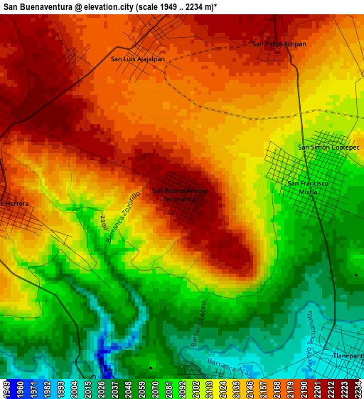
Below is the Elevation map of San Buenaventura, which displays elevation range with different colors. Scale of the first map is from 1949 to 2234 m (6394 to 7329 ft) with average elevation of 2121.1 meters (=6959 ft) [note 1]
These maps also provides idea of topography and contour of this city, they are displayed at different zoom levels. More info about maps, scale and edge coordinates you can find below images.
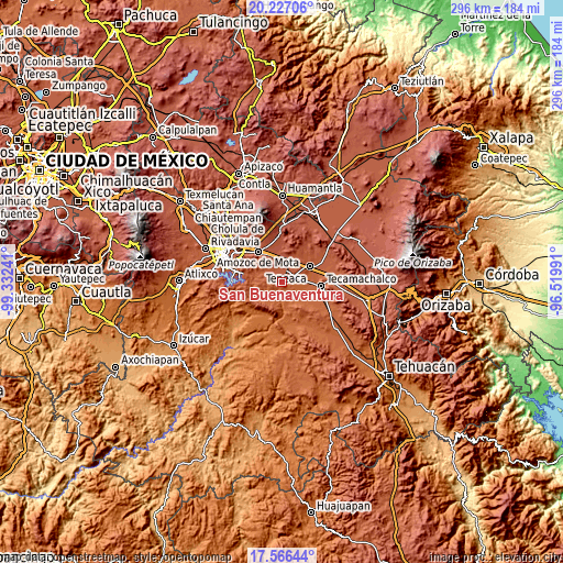
| \ | Map #1 | Topo.Map |
| Scale [m] | 1949..2234 m | × |
| Scale [ft] | 6394..7329 ft | × |
| Average | 2121.1 m = 6959 ft | × |
| Width | 9.25 km = 5.7 mi | 295.8 km = 183.8 mi |
| Height | 9.25 km = 5.7 mi | 295.9 km = 183.9 mi |
| ↑Max Latitude | 18.94361° | 20.22706° |
| Latitude at center | 18.90204° | 18.90204° |
| ↓Min Latitude | 18.860459° | 17.56644° |
| ← Min Longitude | -97.970105° | -99.33241° |
| Longitude center | -97.92616° | -97.92616° |
| →Max Longitude | -97.882215° | -96.51991° |
Nearby cities:
Cities around San Buenaventura sort by population:
• Tepeaca elevation 2244 m
7.7 km,  21°
21°
• San Hipólito 2157 m
7 km,  52°
52°
• Hueyotlipan 2040 m
6.5 km,  100°
100°
• Tecali 2187 m
4.7 km,  268°
268°
• Tlanepantla 2004 m
6 km,  136°
136°
• Ahuatepec 2013 m
4.9 km,  169°
169°
• Actipan 2199 m
4.6 km,  32°
32°
• San Nicolás Zoyapetlayoca 2091 m
6.9 km,  68°
68°
• San Luis Ajajalpan 2180 m
3.9 km,  347°
347°
• Concepción Cuautla 2089 m
7.3 km,  237°
237°
• Mixtla 2086 m
3.2 km,  84°
84°
• Santa Cruz Ajajalpan 2185 m
6.1 km,  335°
335°
Multilingual:
 En español:
San Buenaventura, San Buenaventura Tetlananca elevación 2224 m.
 En France:
San Buenaventura élévation 2224 m.
 Auf Deutsch:
San Buenaventura höhe über dem Meeresspiegel ist 2224 m.

Sources and notes:
- [note 1] Map square and city borders are not equal. Map elevation data is calculated only from area inside that square.
- [src 1] Elevation data from geonames database provided with same terms of usage.
- [src 2] The elevation map of San Buenaventura is generated using elevation data from NASA's 3 arcsec (90m) resolution SRTM data.
- [src 3] Base (background) map © OpenStreetMap contributors tiles are generated by Geofabrik and OpenTopoMap.
Copyright & License:
This San Buenaventura Elevation Map is licensed under CC BY-SA. You may reuse any part from this page, if you give a proper credit by linking to this URL:
 More info on terms of use page.