Actipan elevation
Actipan (Puebla, Tepeaca), Mexico elevation is 2199 meters and Actipan elevation in feet is 7215 ft above sea level [src 1]. Actipan is a populated place (feature code) with elevation that is 885 meters (2904 ft) bigger than average city elevation in Mexico.
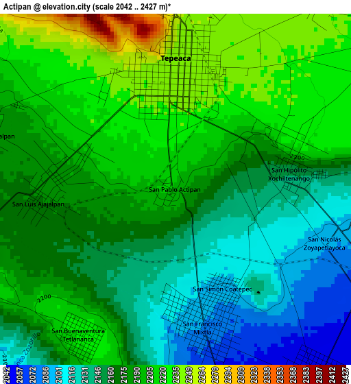
Below is the Elevation map of Actipan, which displays elevation range with different colors. Scale of the first map is from 2042 to 2427 m (6699 to 7963 ft) with average elevation of 2178.1 meters (=7146 ft) [note 1]
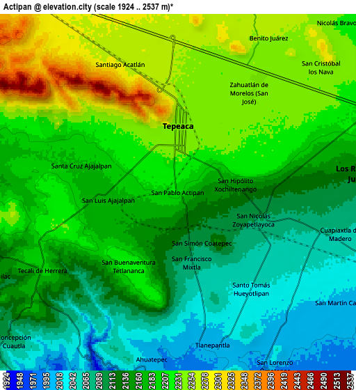
These maps also provides idea of topography and contour of this city, they are displayed at different zoom levels. More info about maps, scale and edge coordinates you can find below images.
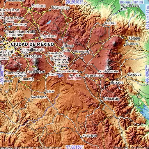
| \ | Map #1 | Map #2 | Topo.Map |
| Scale [m] | 2042..2427 m | 1924..2537 m | × |
| Scale [ft] | 6699..7963 ft | 6312..8323 ft | × |
| Average | 2178.1 m = 7146 ft | 2167.1 m = 7110 ft | × |
| Width | 9.24 km = 5.7 mi | 18.49 km = 11.5 mi | 295.8 km = 183.8 mi |
| Height | 9.24 km = 5.7 mi | 18.49 km = 11.5 mi | 295.8 km = 183.8 mi |
| ↑Max Latitude | 18.978452° | 19.020003° | 20.26163° |
| Latitude at center | 18.93689° | 18.93689° | 18.93689° |
| ↓Min Latitude | 18.895318° | 18.853736° | 17.60156° |
| ← Min Longitude | -97.946465° | -97.990411° | -99.30877° |
| Longitude center | -97.90252° | -97.90252° | -97.90252° |
| →Max Longitude | -97.858575° | -97.814629° | -96.49627° |
Nearby cities:
Cities around Actipan sort by population:
• Tepeaca elevation 2244 m
3.3 km,  4°
4°
• San Hipólito 2157 m
3.1 km,  82°
82°
• Santiago Acatlán 2306 m
7.1 km,  332°
332°
• Hueyotlipan 2040 m
6.4 km,  142°
142°
• San Nicolás Zoyapetlayoca 2091 m
4.2 km,  109°
109°
• San Luis Ajajalpan 2180 m
3.3 km,  268°
268°
• San José Carpinteros 2262 m
6.5 km,  351°
351°
• Zahuatlán de Morelos (San José) 2241 m
6.3 km,  35°
35°
• Mixtla 2086 m
3.6 km,  168°
168°
• San Buenaventura 2224 m
4.6 km,  212°
212°
• Santa Cruz Ajajalpan 2185 m
5.3 km,  288°
288°
• Guadalupe Calderón 2232 m
5.7 km,  55°
55°
Multilingual:
 En español:
Actipan, San Pablo Actipan elevación 2199 m.
 En France:
Actipan élévation 2199 m.
 Auf Deutsch:
Actipan höhe über dem Meeresspiegel ist 2199 m.

Sources and notes:
- [note 1] Map square and city borders are not equal. Map elevation data is calculated only from area inside that square.
- [src 1] Elevation data from geonames database provided with same terms of usage.
- [src 2] The elevation map of Actipan is generated using elevation data from NASA's 3 arcsec (90m) resolution SRTM data.
- [src 3] Base (background) map © OpenStreetMap contributors tiles are generated by Geofabrik and OpenTopoMap.
Copyright & License:
This Actipan Elevation Map is licensed under CC BY-SA. You may reuse any part from this page, if you give a proper credit by linking to this URL:
 More info on terms of use page.