San Hipólito elevation
San Hipólito (Puebla, Tepeaca), Mexico elevation is 2157 meters and San Hipólito elevation in feet is 7077 ft above sea level [src 1]. San Hipólito is a populated place (feature code) with elevation that is 843 meters (2766 ft) bigger than average city elevation in Mexico.
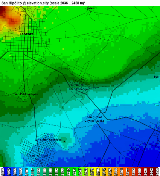
Below is the Elevation map of San Hipólito, which displays elevation range with different colors. Scale of the first map is from 2036 to 2458 m (6680 to 8064 ft) with average elevation of 2164.9 meters (=7103 ft) [note 1]
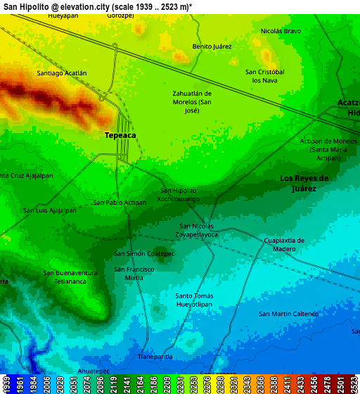
These maps also provides idea of topography and contour of this city, they are displayed at different zoom levels. More info about maps, scale and edge coordinates you can find below images.
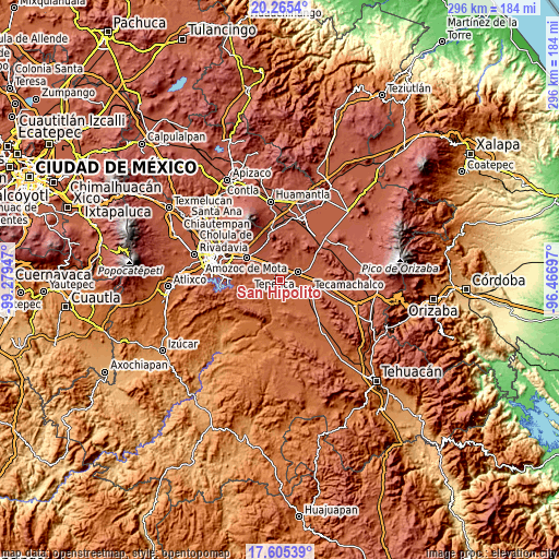
| \ | Map #1 | Map #2 | Topo.Map |
| Scale [m] | 2036..2458 m | 1939..2523 m | × |
| Scale [ft] | 6680..8064 ft | 6362..8278 ft | × |
| Average | 2164.9 m = 7103 ft | 2153.8 m = 7066 ft | × |
| Width | 9.24 km = 5.7 mi | 18.49 km = 11.5 mi | 295.8 km = 183.8 mi |
| Height | 9.24 km = 5.7 mi | 18.49 km = 11.5 mi | 295.8 km = 183.8 mi |
| ↑Max Latitude | 18.982251° | 19.023801° | 20.2654° |
| Latitude at center | 18.94069° | 18.94069° | 18.94069° |
| ↓Min Latitude | 18.899119° | 18.857538° | 17.60539° |
| ← Min Longitude | -97.917165° | -97.961111° | -99.27947° |
| Longitude center | -97.87322° | -97.87322° | -97.87322° |
| →Max Longitude | -97.829275° | -97.785329° | -96.46697° |
Nearby cities:
Cities around San Hipólito sort by population:
• Tepeaca elevation 2244 m
4 km,  316°
316°
• Cuapiaxtla de Madero 2061 m
5.9 km,  118°
118°
• Hueyotlipan 2040 m
5.5 km,  171°
171°
• Actipan 2199 m
3.1 km,  262°
262°
• San Nicolás Zoyapetlayoca 2091 m
2 km,  155°
155°
• San Luis Ajajalpan 2180 m
6.4 km,  265°
265°
• San Mateo Parra 2245 m
5.8 km,  12°
12°
• Zahuatlán de Morelos (San José) 2241 m
4.8 km, 7°
• Buenavista de Juárez 2137 m
4.8 km,  84°
84°
• Mixtla 2086 m
4.6 km,  210°
210°
• Guadalupe Calderón 2232 m
3.2 km,  28°
28°
• Miguel Negrete 2165 m
4.8 km,  74°
74°
Multilingual:
 En español:
San Hipólito elevación 2157 m.
 En France:
San Hipólito élévation 2157 m.
 Auf Deutsch:
San Hipólito höhe über dem Meeresspiegel ist 2157 m.

Sources and notes:
- [note 1] Map square and city borders are not equal. Map elevation data is calculated only from area inside that square.
- [src 1] Elevation data from geonames database provided with same terms of usage.
- [src 2] The elevation map of San Hipólito is generated using elevation data from NASA's 3 arcsec (90m) resolution SRTM data.
- [src 3] Base (background) map © OpenStreetMap contributors tiles are generated by Geofabrik and OpenTopoMap.
Copyright & License:
This San Hipólito Elevation Map is licensed under CC BY-SA. You may reuse any part from this page, if you give a proper credit by linking to this URL:
 More info on terms of use page.