San Antonio Juárez elevation
San Antonio Juárez (Puebla, Tzicatlacoyan), Mexico elevation is 2081 meters and San Antonio Juárez elevation in feet is 6827 ft above sea level [src 1]. San Antonio Juárez is a populated place (feature code) with elevation that is 767 meters (2516 ft) bigger than average city elevation in Mexico.
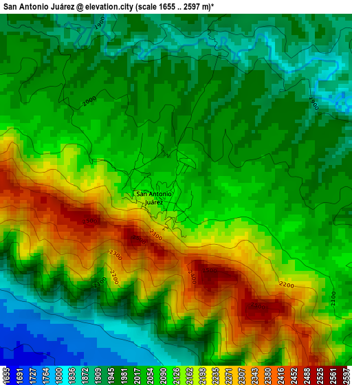
Below is the Elevation map of San Antonio Juárez, which displays elevation range with different colors. Scale of the first map is from 1655 to 2597 m (5430 to 8520 ft) with average elevation of 2059.8 meters (=6758 ft) [note 1]
These maps also provides idea of topography and contour of this city, they are displayed at different zoom levels. More info about maps, scale and edge coordinates you can find below images.
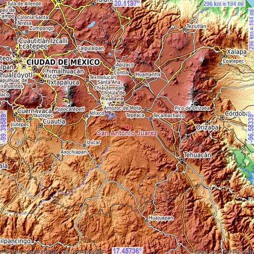
| \ | Map #1 | Topo.Map |
| Scale [m] | 1655..2597 m | × |
| Scale [ft] | 5430..8520 ft | × |
| Average | 2059.8 m = 6758 ft | × |
| Width | 9.25 km = 5.7 mi | 296 km = 183.9 mi |
| Height | 9.25 km = 5.7 mi | 296 km = 183.9 mi |
| ↑Max Latitude | 18.835387° | 20.1197° |
| Latitude at center | 18.79379° | 18.79379° |
| ↓Min Latitude | 18.752183° | 17.45736° |
| ← Min Longitude | -98.033585° | -99.39589° |
| Longitude center | -97.98964° | -97.98964° |
| →Max Longitude | -97.945695° | -96.58339° |
Nearby cities:
Cities around San Antonio Juárez sort by population:
• Atoyatempan elevation 1952 m
8.5 km,  70°
70°
• Tecali 2187 m
12 km,  9°
9°
• Tlanepantla 2004 m
13.3 km,  54°
54°
• Ahuatepec 2013 m
10.4 km, 46°
• Santa Clara Huitziltepec 1919 m
11.7 km,  103°
103°
• Concepción Cuautla 2089 m
8.2 km,  3°
3°
• La Trinidad Tianguismanalco 2156 m
12 km,  337°
337°
• Santa Cruz Huitziltepec 1857 m
13.7 km,  119°
119°
• Santa Ana Coapan 1961 m
11.1 km, 68°
• Tzicatlacoyan 2015 m
8.1 km,  310°
310°
• San Juan Atzompa 1652 m
6.6 km,  214°
214°
• Tepeyahualco 1942 m
12.1 km,  79°
79°
Multilingual:
 En español:
San Antonio Juárez elevación 2081 m.
 En France:
San Antonio Juárez élévation 2081 m.
 Auf Deutsch:
San Antonio Juárez höhe über dem Meeresspiegel ist 2081 m.
 На русском:
San Antonio Juárez высота над уровнем моря 2081 м
Sources and notes:
- [note 1] Map square and city borders are not equal. Map elevation data is calculated only from area inside that square.
- [src 1] Elevation data from geonames database provided with same terms of usage.
- [src 2] The elevation map of San Antonio Juárez is generated using elevation data from NASA's 3 arcsec (90m) resolution SRTM data.
- [src 3] Base (background) map © OpenStreetMap contributors tiles are generated by Geofabrik and OpenTopoMap.
Copyright & License:
This San Antonio Juárez Elevation Map is licensed under CC BY-SA. You may reuse any part from this page, if you give a proper credit by linking to this URL:
 More info on terms of use page.