Cuautinchán elevation
Cuautinchán (Puebla), Mexico elevation is 2156 meters and Cuautinchán elevation in feet is 7073 ft above sea level [src 1]. Cuautinchán is a populated place (feature code) with elevation that is 842 meters (2762 ft) bigger than average city elevation in Mexico.
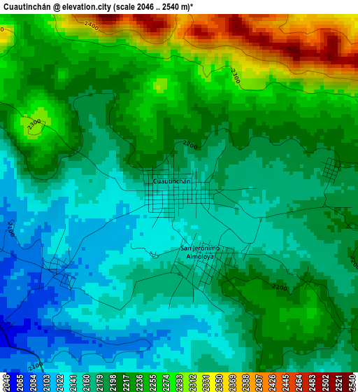
Below is the Elevation map of Cuautinchán, which displays elevation range with different colors. Scale of the first map is from 2046 to 2540 m (6713 to 8333 ft) with average elevation of 2203.3 meters (=7229 ft) [note 1]
These maps also provides idea of topography and contour of this city, they are displayed at different zoom levels. More info about maps, scale and edge coordinates you can find below images.
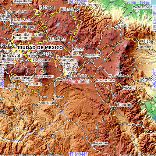
| \ | Map #1 | Topo.Map |
| Scale [m] | 2046..2540 m | × |
| Scale [ft] | 6713..8333 ft | × |
| Average | 2203.3 m = 7229 ft | × |
| Width | 9.24 km = 5.7 mi | 295.7 km = 183.7 mi |
| Height | 9.24 km = 5.7 mi | 295.8 km = 183.8 mi |
| ↑Max Latitude | 18.996187° | 20.27922° |
| Latitude at center | 18.95463° | 18.95463° |
| ↓Min Latitude | 18.913062° | 17.61944° |
| ← Min Longitude | -98.059605° | -99.42191° |
| Longitude center | -98.01566° | -98.01566° |
| →Max Longitude | -97.971715° | -96.60941° |
Nearby cities:
Cities around Cuautinchán sort by population:
• Amozoc de Mota elevation 2316 m
10.6 km,  343°
343°
• Santiago Acatlán 2306 m
9.6 km,  63°
63°
• San Agustín Tlaxco 2341 m
11.6 km,  12°
12°
• Tecali 2187 m
7.6 km,  141°
141°
• San Jerónimo Ocotitla 2294 m
10.1 km,  32°
32°
• San Jerónimo Almoloya 2153 m
1.6 km,  160°
160°
• San Luis Ajajalpan 2180 m
8.8 km,  103°
103°
• San José Carpinteros 2262 m
11.8 km,  67°
67°
• Concepción Cuautla 2089 m
10.2 km, 161°
• La Trinidad Tianguismanalco 2156 m
7 km,  194°
194°
• San Buenaventura 2224 m
11.1 km,  121°
121°
• Santa Cruz Ajajalpan 2185 m
6.9 km,  92°
92°
Multilingual:
 En español:
Cuautinchán elevación 2156 m.
 En France:
Cuautinchán élévation 2156 m.
 Auf Deutsch:
Cuautinchán höhe über dem Meeresspiegel ist 2156 m.

Sources and notes:
- [note 1] Map square and city borders are not equal. Map elevation data is calculated only from area inside that square.
- [src 1] Elevation data from geonames database provided with same terms of usage.
- [src 2] The elevation map of Cuautinchán is generated using elevation data from NASA's 3 arcsec (90m) resolution SRTM data.
- [src 3] Base (background) map © OpenStreetMap contributors tiles are generated by Geofabrik and OpenTopoMap.
Copyright & License:
This Cuautinchán Elevation Map is licensed under CC BY-SA. You may reuse any part from this page, if you give a proper credit by linking to this URL:
 More info on terms of use page.