Tepexi de Rodríguez elevation
Tepexi de Rodríguez (Puebla), Mexico elevation is 1726 meters and Tepexi de Rodríguez elevation in feet is 5663 ft above sea level [src 1]. Tepexi de Rodríguez is a populated place (feature code) with elevation that is 412 meters (1352 ft) bigger than average city elevation in Mexico.
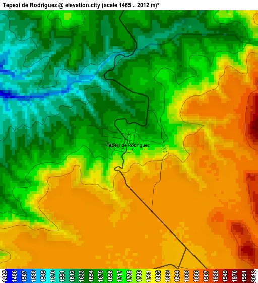
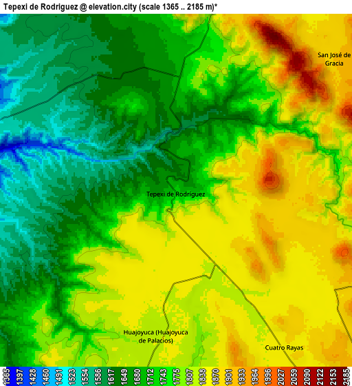
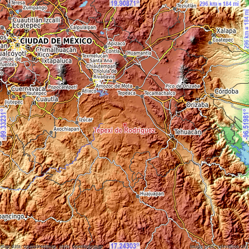
Below is the Elevation map of Tepexi de Rodríguez, which displays elevation range with different colors. Scale of the first map is from 1465 to 2012 m (4806 to 6601 ft) with average elevation of 1749.1 meters (=5739 ft) [note 1]
These maps also provides idea of topography and contour of this city, they are displayed at different zoom levels. More info about maps, scale and edge coordinates you can find below images.
| \ | Map #1 | Map #2 | Topo.Map |
| Scale [m] | 1465..2012 m | 1365..2185 m | × |
| Scale [ft] | 4806..6601 ft | 4478..7169 ft | × |
| Average | 1749.1 m = 5739 ft | 1755.9 m = 5761 ft | × |
| Width | 9.26 km = 5.8 mi | 18.53 km = 11.5 mi | 296.4 km = 184.2 mi |
| Height | 9.26 km = 5.8 mi | 18.53 km = 11.5 mi | 296.4 km = 184.2 mi |
| ↑Max Latitude | 18.62273° | 18.664369° | 19.90871° |
| Latitude at center | 18.58108° | 18.58108° | 18.58108° |
| ↓Min Latitude | 18.53942° | 18.49775° | 17.24303° |
| ← Min Longitude | -97.970005° | -98.013951° | -99.33231° |
| Longitude center | -97.92606° | -97.92606° | -97.92606° |
| →Max Longitude | -97.882115° | -97.838169° | -96.51981° |
Nearby cities:
Cities around Tepexi de Rodríguez sort by population:
• San Juan Ixcaquixtla elevation 1913 m
16.7 km,  143°
143°
• Huajoyuca 1834 m
7.7 km,  188°
188°
• Juan N. Méndez 1935 m
16.8 km,  104°
104°
• Huejonapan 1797 m
12.4 km,  177°
177°
• Almolonga 1837 m
12.3 km,  198°
198°
• Chigmecatitlán 1524 m
17 km,  295°
295°
• San José de Gracia 1902 m
10.8 km,  50°
50°
• Zacapala 1326 m
14.8 km,  275°
275°
• Tula 1839 m
5 km,  159°
159°
• El Progreso 1891 m
7.6 km,  107°
107°
• Santa Catarina Tlaltempan 1493 m
16.7 km, 283°
• Huatlatlauca 1580 m
17.2 km,  310°
310°
Multilingual:
 En español:
Tepexi de Rodríguez elevación 1726 m.
 En France:
Tepexi de Rodríguez élévation 1726 m.
 Auf Deutsch:
Tepexi de Rodríguez höhe über dem Meeresspiegel ist 1726 m.
 На русском:
Tepexi de Rodríguez высота над уровнем моря 1726 м
Sources and notes:
- [note 1] Map square and city borders are not equal. Map elevation data is calculated only from area inside that square.
- [src 1] Elevation data from geonames database provided with same terms of usage.
- [src 2] The elevation map of Tepexi de Rodríguez is generated using elevation data from NASA's 3 arcsec (90m) resolution SRTM data.
- [src 3] Base (background) map © OpenStreetMap contributors tiles are generated by Geofabrik and OpenTopoMap.
Copyright & License:
This Tepexi de Rodríguez Elevation Map is licensed under CC BY-SA. You may reuse any part from this page, if you give a proper credit by linking to this URL:
 More info on terms of use page.