San Martín Esperilla elevation
San Martín Esperilla (Puebla, Tlacotepec de Benito Juárez), Mexico elevation is 2437 meters and San Martín Esperilla elevation in feet is 7995 ft above sea level [src 1]. San Martín Esperilla is a populated place (feature code) with elevation that is 1123 meters (3684 ft) bigger than average city elevation in Mexico.
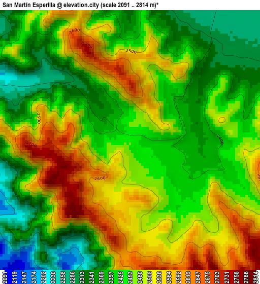
Below is the Elevation map of San Martín Esperilla, which displays elevation range with different colors. Scale of the first map is from 2091 to 2814 m (6860 to 9232 ft) with average elevation of 2454.8 meters (=8054 ft) [note 1]
These maps also provides idea of topography and contour of this city, they are displayed at different zoom levels. More info about maps, scale and edge coordinates you can find below images.
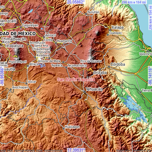
| \ | Map #1 | Topo.Map |
| Scale [m] | 2091..2814 m | × |
| Scale [ft] | 6860..9232 ft | × |
| Average | 2454.8 m = 8054 ft | × |
| Width | 9.25 km = 5.7 mi | 296.1 km = 184 mi |
| Height | 9.25 km = 5.7 mi | 296.2 km = 184 mi |
| ↑Max Latitude | 18.773822° | 20.05862° |
| Latitude at center | 18.73221° | 18.73221° |
| ↓Min Latitude | 18.690587° | 17.39531° |
| ← Min Longitude | -97.591355° | -98.95366° |
| Longitude center | -97.54741° | -97.54741° |
| →Max Longitude | -97.503465° | -96.14116° |
Nearby cities:
Cities around San Martín Esperilla sort by population:
• San Marcos Tlacoyalco elevation 1966 m
8.8 km,  222°
222°
• Tlacotepec 1944 m
12.7 km,  243°
243°
• Cuacnopalan 2227 m
10.2 km,  21°
21°
• Yehualtepec 2130 m
13.9 km,  300°
300°
• Palmar de Bravo 2199 m
11.5 km,  0°
0°
• San Miguel Zozutla 2047 m
11.6 km,  282°
282°
• Morelos Cañada 2297 m
13.3 km,  88°
88°
• San José Ixtapa 2328 m
9.4 km,  101°
101°
• La Purísima 2203 m
11.2 km,  346°
346°
• San José Buenavista 1988 m
8.7 km,  202°
202°
• Rancho Chico 2016 m
12.5 km, 277°
• San José Tlacuitlapan 2015 m
8.7 km,  251°
251°
Multilingual:
 En español:
San Martín Esperilla elevación 2437 m.
 En France:
San Martín Esperilla élévation 2437 m.
 Auf Deutsch:
San Martín Esperilla höhe über dem Meeresspiegel ist 2437 m.
 На русском:
San Martín Esperilla высота над уровнем моря 2437 м
Sources and notes:
- [note 1] Map square and city borders are not equal. Map elevation data is calculated only from area inside that square.
- [src 1] Elevation data from geonames database provided with same terms of usage.
- [src 2] The elevation map of San Martín Esperilla is generated using elevation data from NASA's 3 arcsec (90m) resolution SRTM data.
- [src 3] Base (background) map © OpenStreetMap contributors tiles are generated by Geofabrik and OpenTopoMap.
Copyright & License:
This San Martín Esperilla Elevation Map is licensed under CC BY-SA. You may reuse any part from this page, if you give a proper credit by linking to this URL:
 More info on terms of use page.