Yehualtepec elevation
Yehualtepec (Puebla), Mexico elevation is 2130 meters and Yehualtepec elevation in feet is 6988 ft above sea level [src 1]. Yehualtepec is a seat of a second-order administrative division (feature code) with elevation that is 816 meters (2677 ft) bigger than average city elevation in Mexico.
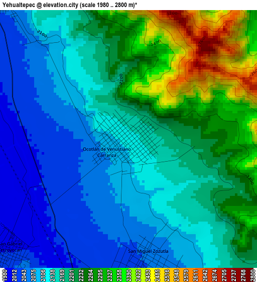
Below is the Elevation map of Yehualtepec, which displays elevation range with different colors. Scale of the first map is from 1980 to 2800 m (6496 to 9186 ft) with average elevation of 2182.3 meters (=7160 ft) [note 1]
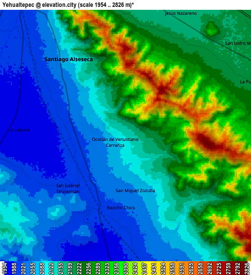
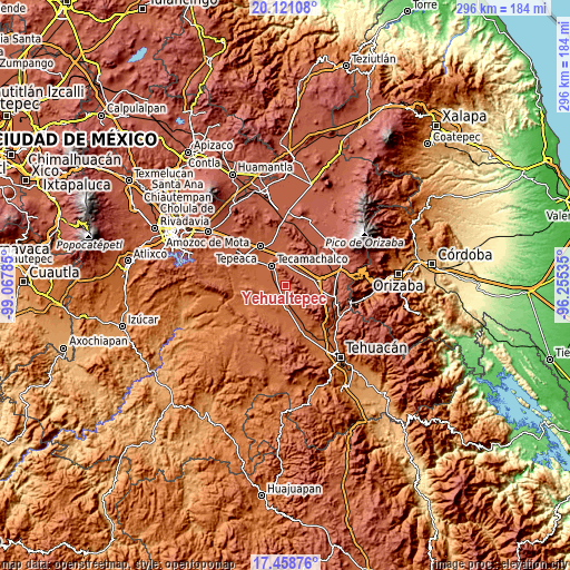
These maps also provides idea of topography and contour of this city, they are displayed at different zoom levels. More info about maps, scale and edge coordinates you can find below images.
| \ | Map #1 | Map #2 | Topo.Map |
| Scale [m] | 1980..2800 m | 1954..2826 m | × |
| Scale [ft] | 6496..9186 ft | 6411..9272 ft | × |
| Average | 2182.3 m = 7160 ft | 2175.7 m = 7138 ft | × |
| Width | 9.25 km = 5.7 mi | 18.5 km = 11.5 mi | 296 km = 183.9 mi |
| Height | 9.25 km = 5.7 mi | 18.5 km = 11.5 mi | 296 km = 183.9 mi |
| ↑Max Latitude | 18.836777° | 18.878363° | 20.12108° |
| Latitude at center | 18.79518° | 18.79518° | 18.79518° |
| ↓Min Latitude | 18.753573° | 18.711955° | 17.45876° |
| ← Min Longitude | -97.705545° | -97.749491° | -99.06785° |
| Longitude center | -97.6616° | -97.6616° | -97.6616° |
| →Max Longitude | -97.617655° | -97.573709° | -96.25535° |
Nearby cities:
Cities around Yehualtepec sort by population:
• Santiago Alseseca elevation 2058 m
7.3 km,  319°
319°
• San Gabriel Tetzoyocán 2012 m
6.1 km,  226°
226°
• San Miguel Zozutla 2047 m
4.6 km,  171°
171°
• La Purísima 2203 m
10.1 km,  67°
67°
• Jesús Nazareno 2169 m
9.9 km,  24°
24°
• Xochimilco 2000 m
8.5 km,  307°
307°
• San Antonio la Portilla 1970 m
10.7 km,  270°
270°
• Rancho Chico 2016 m
5.4 km,  183°
183°
• Ocotlán de Venustiano Carranza 2083 m
0.9 km,  240°
240°
• La Laguna 1973 m
7.9 km, 273°
• La Soledad 1974 m
10.9 km,  278°
278°
• San José Tlacuitlapan 2015 m
10.5 km,  158°
158°
Multilingual:
 En español:
San Simón elevación 2130 m.
 En France:
Yehualtepec élévation 2130 m.
 Auf Deutsch:
Yehualtepec höhe über dem Meeresspiegel ist 2130 m.

Sources and notes:
- [note 1] Map square and city borders are not equal. Map elevation data is calculated only from area inside that square.
- [src 1] Elevation data from geonames database provided with same terms of usage.
- [src 2] The elevation map of Yehualtepec is generated using elevation data from NASA's 3 arcsec (90m) resolution SRTM data.
- [src 3] Base (background) map © OpenStreetMap contributors tiles are generated by Geofabrik and OpenTopoMap.
Copyright & License:
This Yehualtepec Elevation Map is licensed under CC BY-SA. You may reuse any part from this page, if you give a proper credit by linking to this URL:
 More info on terms of use page.