San Gabriel Tetzoyocán elevation
San Gabriel Tetzoyocán (Puebla, Yehualtepec), Mexico elevation is 2012 meters and San Gabriel Tetzoyocán elevation in feet is 6601 ft above sea level [src 1]. San Gabriel Tetzoyocán is a populated place (feature code) with elevation that is 698 meters (2290 ft) bigger than average city elevation in Mexico.
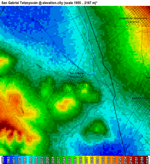
Below is the Elevation map of San Gabriel Tetzoyocán, which displays elevation range with different colors. Scale of the first map is from 1955 to 2167 m (6414 to 7110 ft) with average elevation of 2021.4 meters (=6632 ft) [note 1]
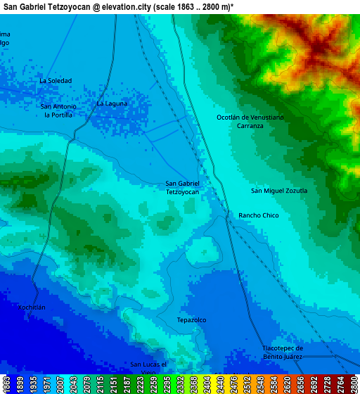
These maps also provides idea of topography and contour of this city, they are displayed at different zoom levels. More info about maps, scale and edge coordinates you can find below images.
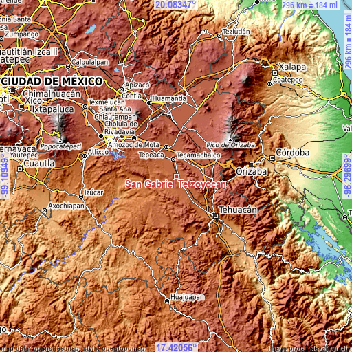
| \ | Map #1 | Map #2 | Topo.Map |
| Scale [m] | 1955..2167 m | 1863..2800 m | × |
| Scale [ft] | 6414..7110 ft | 6112..9186 ft | × |
| Average | 2021.4 m = 6632 ft | 2054.1 m = 6739 ft | × |
| Width | 9.25 km = 5.7 mi | 18.51 km = 11.5 mi | 296.1 km = 184 mi |
| Height | 9.25 km = 5.7 mi | 18.51 km = 11.5 mi | 296.1 km = 184 mi |
| ↑Max Latitude | 18.798876° | 18.840472° | 20.08347° |
| Latitude at center | 18.75727° | 18.75727° | 18.75727° |
| ↓Min Latitude | 18.715654° | 18.674027° | 17.42056° |
| ← Min Longitude | -97.747185° | -97.791131° | -99.10949° |
| Longitude center | -97.70324° | -97.70324° | -97.70324° |
| →Max Longitude | -97.659295° | -97.615349° | -96.29699° |
Nearby cities:
Cities around San Gabriel Tetzoyocán sort by population:
• Tlacotepec elevation 1944 m
9.7 km,  149°
149°
• Yehualtepec 2130 m
6.1 km,  46°
46°
• Xochitlan Todos Santos 1908 m
9.7 km,  232°
232°
• San Miguel Zozutla 2047 m
5.1 km,  93°
93°
• Santo Nombre 1926 m
9.7 km,  162°
162°
• San Antonio la Portilla 1970 m
7.6 km,  304°
304°
• Rancho Chico 2016 m
4.2 km,  106°
106°
• Tepazolco 1971 m
6.4 km,  173°
173°
• Ocotlán de Venustiano Carranza 2083 m
5.2 km,  43°
43°
• San Lucas el Viejo 1922 m
9 km,  190°
190°
• La Laguna 1973 m
5.9 km,  323°
323°
• La Soledad 1974 m
8.7 km,  312°
312°
Multilingual:
 En español:
San Gabriel Tetzoyocán elevación 2012 m.
 En France:
San Gabriel Tetzoyocán élévation 2012 m.
 Auf Deutsch:
San Gabriel Tetzoyocán höhe über dem Meeresspiegel ist 2012 m.
 На русском:
San Gabriel Tetzoyocán высота над уровнем моря 2012 м
Sources and notes:
- [note 1] Map square and city borders are not equal. Map elevation data is calculated only from area inside that square.
- [src 1] Elevation data from geonames database provided with same terms of usage.
- [src 2] The elevation map of San Gabriel Tetzoyocán is generated using elevation data from NASA's 3 arcsec (90m) resolution SRTM data.
- [src 3] Base (background) map © OpenStreetMap contributors tiles are generated by Geofabrik and OpenTopoMap.
Copyright & License:
This San Gabriel Tetzoyocán Elevation Map is licensed under CC BY-SA. You may reuse any part from this page, if you give a proper credit by linking to this URL:
 More info on terms of use page.