Morelos Cañada elevation
Morelos Cañada (Puebla, Cañada Morelos), Mexico elevation is 2297 meters and Morelos Cañada elevation in feet is 7536 ft above sea level [src 1]. Morelos Cañada is a seat of a second-order administrative division (feature code) with elevation that is 983 meters (3225 ft) bigger than average city elevation in Mexico.
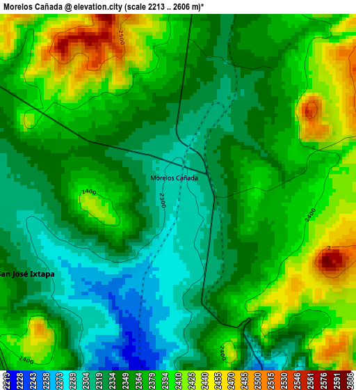
Below is the Elevation map of Morelos Cañada, which displays elevation range with different colors. Scale of the first map is from 2213 to 2606 m (7260 to 8550 ft) with average elevation of 2363.6 meters (=7755 ft) [note 1]
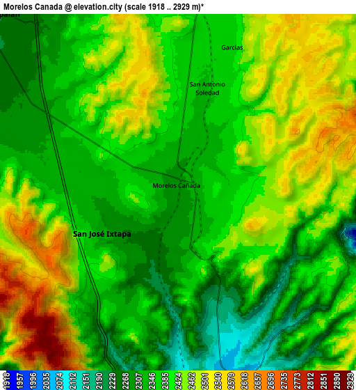
These maps also provides idea of topography and contour of this city, they are displayed at different zoom levels. More info about maps, scale and edge coordinates you can find below images.
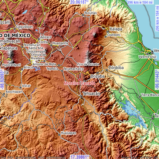
| \ | Map #1 | Map #2 | Topo.Map |
| Scale [m] | 2213..2606 m | 1918..2929 m | × |
| Scale [ft] | 7260..8550 ft | 6293..9610 ft | × |
| Average | 2363.6 m = 7755 ft | 2394.4 m = 7856 ft | × |
| Width | 9.25 km = 5.7 mi | 18.51 km = 11.5 mi | 296.1 km = 184 mi |
| Height | 9.25 km = 5.7 mi | 18.51 km = 11.5 mi | 296.1 km = 184 mi |
| ↑Max Latitude | 18.777102° | 18.818703° | 20.06187° |
| Latitude at center | 18.73549° | 18.73549° | 18.73549° |
| ↓Min Latitude | 18.693868° | 18.652236° | 17.39861° |
| ← Min Longitude | -97.464625° | -97.508571° | -98.82693° |
| Longitude center | -97.42068° | -97.42068° | -97.42068° |
| →Max Longitude | -97.376735° | -97.332789° | -96.01443° |
Nearby cities:
Cities around Morelos Cañada sort by population:
• Cuacnopalan elevation 2227 m
13.2 km,  313°
313°
• Esperanza 2456 m
14.5 km,  18°
18°
• Acultzingo 1670 m
12.5 km,  98°
98°
• Chapulco 2013 m
12.3 km,  172°
172°
• Cuesta Blanca 2370 m
13.2 km,  338°
338°
• Azumbilla 2039 m
10.3 km, 166°
• Huiloapan 2248 m
11.1 km,  81°
81°
• San José Ixtapa 2328 m
4.6 km,  241°
241°
• San Antonio Soledad 2337 m
5.6 km,  14°
14°
• San Martín Esperilla 2437 m
13.3 km,  268°
268°
• Los Garcías 2369 m
8 km, 20°
• Aquila 1838 m
13.6 km,  60°
60°
Multilingual:
 En español:
Morelos Cañada elevación 2297 m.
 En France:
Morelos Cañada élévation 2297 m.
 Auf Deutsch:
Morelos Cañada höhe über dem Meeresspiegel ist 2297 m.

Sources and notes:
- [note 1] Map square and city borders are not equal. Map elevation data is calculated only from area inside that square.
- [src 1] Elevation data from geonames database provided with same terms of usage.
- [src 2] The elevation map of Morelos Cañada is generated using elevation data from NASA's 3 arcsec (90m) resolution SRTM data.
- [src 3] Base (background) map © OpenStreetMap contributors tiles are generated by Geofabrik and OpenTopoMap.
Copyright & License:
This Morelos Cañada Elevation Map is licensed under CC BY-SA. You may reuse any part from this page, if you give a proper credit by linking to this URL:
 More info on terms of use page.