Huiloapan elevation
Huiloapan (Veracruz, Acultzingo), Mexico elevation is 2248 meters and Huiloapan elevation in feet is 7375 ft above sea level [src 1]. Huiloapan is a populated place (feature code) with elevation that is 934 meters (3064 ft) bigger than average city elevation in Mexico.
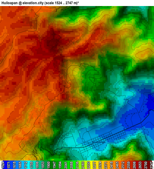
Below is the Elevation map of Huiloapan, which displays elevation range with different colors. Scale of the first map is from 1524 to 2747 m (5000 to 9012 ft) with average elevation of 2199.4 meters (=7216 ft) [note 1]
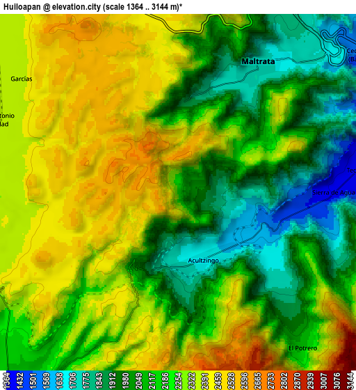
These maps also provides idea of topography and contour of this city, they are displayed at different zoom levels. More info about maps, scale and edge coordinates you can find below images.
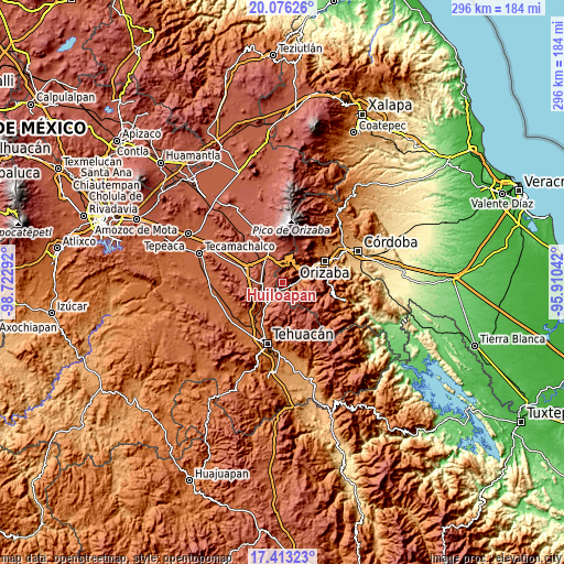
| \ | Map #1 | Map #2 | Topo.Map |
| Scale [m] | 1524..2747 m | 1364..3144 m | × |
| Scale [ft] | 5000..9012 ft | 4475..10315 ft | × |
| Average | 2199.4 m = 7216 ft | 2203.5 m = 7229 ft | × |
| Width | 9.25 km = 5.7 mi | 18.51 km = 11.5 mi | 296.1 km = 184 mi |
| Height | 9.25 km = 5.7 mi | 18.51 km = 11.5 mi | 296.1 km = 184 mi |
| ↑Max Latitude | 18.791608° | 18.833206° | 20.07626° |
| Latitude at center | 18.75° | 18.75° | 18.75° |
| ↓Min Latitude | 18.708382° | 18.666753° | 17.41323° |
| ← Min Longitude | -97.360615° | -97.404561° | -98.72292° |
| Longitude center | -97.31667° | -97.31667° | -97.31667° |
| →Max Longitude | -97.272725° | -97.228779° | -95.91042° |
Nearby cities:
Cities around Huiloapan sort by population:
• Maltrata elevation 1720 m
8 km,  32°
32°
• Acultzingo 1670 m
3.7 km,  158°
158°
• Morelos Cañada 2297 m
11.1 km,  261°
261°
• Tecamalucan 1380 m
9.7 km,  82°
82°
• San Antonio Soledad 2337 m
10.3 km,  291°
291°
• Cecilio Terán 1486 m
12 km,  53°
53°
• Acatla 1439 m
10.4 km,  90°
90°
• El Potrero 2075 m
10.3 km,  140°
140°
• Sierra de Agua 1399 m
7.9 km, 89°
• San José Cuyachapa 2625 m
11.6 km,  1°
1°
• Los Garcías 2369 m
10.1 km,  306°
306°
• Aquila 1838 m
5.1 km,  9°
9°
Multilingual:
 En español:
Huiloapan elevación 2248 m.
 En France:
Huiloapan élévation 2248 m.
 Auf Deutsch:
Huiloapan höhe über dem Meeresspiegel ist 2248 m.

Sources and notes:
- [note 1] Map square and city borders are not equal. Map elevation data is calculated only from area inside that square.
- [src 1] Elevation data from geonames database provided with same terms of usage.
- [src 2] The elevation map of Huiloapan is generated using elevation data from NASA's 3 arcsec (90m) resolution SRTM data.
- [src 3] Base (background) map © OpenStreetMap contributors tiles are generated by Geofabrik and OpenTopoMap.
Copyright & License:
This Huiloapan Elevation Map is licensed under CC BY-SA. You may reuse any part from this page, if you give a proper credit by linking to this URL:
 More info on terms of use page.