Azumbilla elevation
Azumbilla (Puebla, Nicolás Bravo), Mexico elevation is 2039 meters and Azumbilla elevation in feet is 6690 ft above sea level [src 1]. Azumbilla is a populated place (feature code) with elevation that is 725 meters (2379 ft) bigger than average city elevation in Mexico.
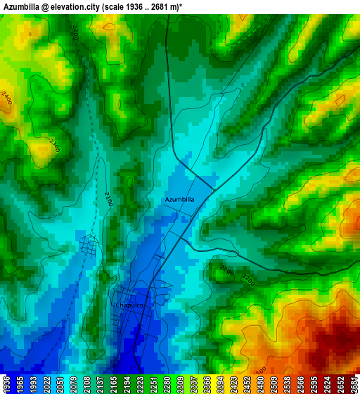
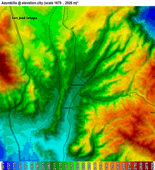
Below is the Elevation map of Azumbilla, which displays elevation range with different colors. Scale of the first map is from 1936 to 2681 m (6352 to 8796 ft) with average elevation of 2186.7 meters (=7174 ft) [note 1]
These maps also provides idea of topography and contour of this city, they are displayed at different zoom levels. More info about maps, scale and edge coordinates you can find below images.
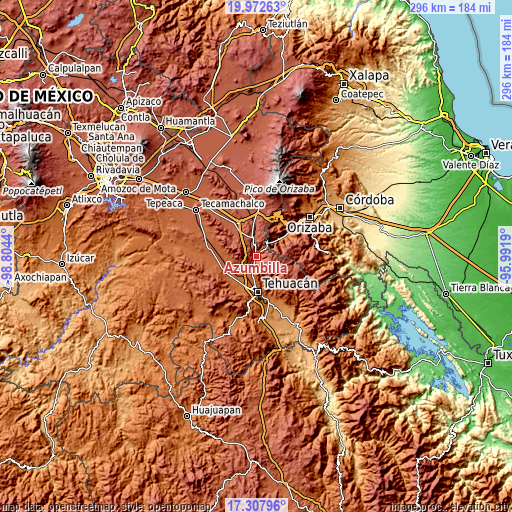
| \ | Map #1 | Map #2 | Topo.Map |
| Scale [m] | 1936..2681 m | 1679..2926 m | × |
| Scale [ft] | 6352..8796 ft | 5509..9600 ft | × |
| Average | 2186.7 m = 7174 ft | 2281.6 m = 7486 ft | × |
| Width | 9.26 km = 5.8 mi | 18.52 km = 11.5 mi | 296.3 km = 184.1 mi |
| Height | 9.26 km = 5.8 mi | 18.52 km = 11.5 mi | 296.3 km = 184.1 mi |
| ↑Max Latitude | 18.687154° | 18.728777° | 19.97263° |
| Latitude at center | 18.64552° | 18.64552° | 18.64552° |
| ↓Min Latitude | 18.603876° | 18.562222° | 17.30796° |
| ← Min Longitude | -97.442095° | -97.486041° | -98.8044° |
| Longitude center | -97.39815° | -97.39815° | -97.39815° |
| →Max Longitude | -97.354205° | -97.310259° | -95.9919° |
Nearby cities:
Cities around Azumbilla sort by population:
• Miahuatlán elevation 1784 m
11.5 km,  202°
202°
• Magdalena Cuayucatepec 1741 m
14 km,  220°
220°
• Acultzingo 1670 m
12.9 km,  50°
50°
• Chapulco 2013 m
2.3 km, 197°
• Morelos Cañada 2297 m
10.3 km,  346°
346°
• Huiloapan 2248 m
14.4 km,  36°
36°
• San José Ixtapa 2328 m
10.1 km,  320°
320°
• San Isidro Vista Hermosa 1754 m
15.6 km,  180°
180°
• San Antonio Soledad 2337 m
15.4 km,  356°
356°
• San Bernardino Lagunas 2553 m
14.7 km,  108°
108°
• El Potrero 2075 m
15.5 km,  76°
76°
• Nicolás Bravo 2526 m
10 km, 108°
Multilingual:
 En español:
Azumbilla elevación 2039 m.
 En France:
Azumbilla élévation 2039 m.
 Auf Deutsch:
Azumbilla höhe über dem Meeresspiegel ist 2039 m.

Sources and notes:
- [note 1] Map square and city borders are not equal. Map elevation data is calculated only from area inside that square.
- [src 1] Elevation data from geonames database provided with same terms of usage.
- [src 2] The elevation map of Azumbilla is generated using elevation data from NASA's 3 arcsec (90m) resolution SRTM data.
- [src 3] Base (background) map © OpenStreetMap contributors tiles are generated by Geofabrik and OpenTopoMap.
Copyright & License:
This Azumbilla Elevation Map is licensed under CC BY-SA. You may reuse any part from this page, if you give a proper credit by linking to this URL:
 More info on terms of use page.