Magdalena Cuayucatepec elevation
Magdalena Cuayucatepec (Puebla, Tehuacán), Mexico elevation is 1741 meters and Magdalena Cuayucatepec elevation in feet is 5712 ft above sea level [src 1]. Magdalena Cuayucatepec is a populated place (feature code) with elevation that is 427 meters (1401 ft) bigger than average city elevation in Mexico.
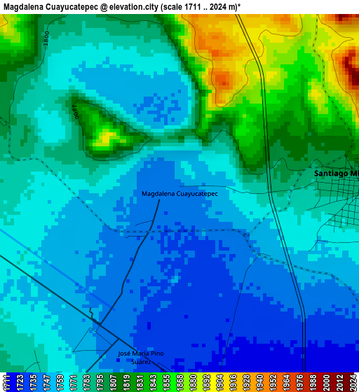
Below is the Elevation map of Magdalena Cuayucatepec, which displays elevation range with different colors. Scale of the first map is from 1711 to 2024 m (5614 to 6640 ft) with average elevation of 1781.4 meters (=5844 ft) [note 1]
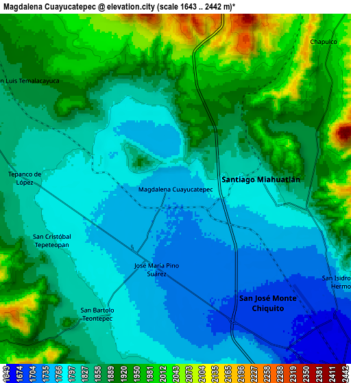
These maps also provides idea of topography and contour of this city, they are displayed at different zoom levels. More info about maps, scale and edge coordinates you can find below images.
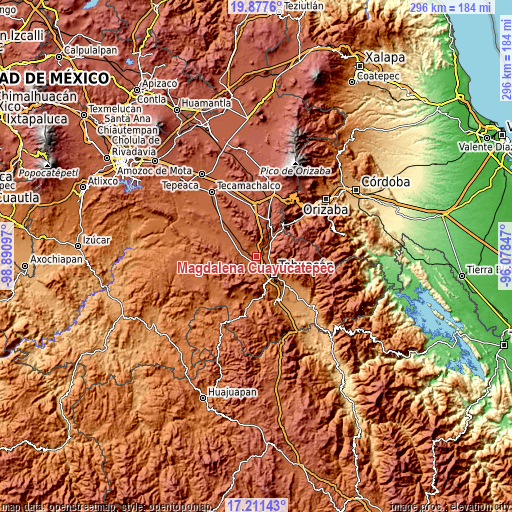
| \ | Map #1 | Map #2 | Topo.Map |
| Scale [m] | 1711..2024 m | 1643..2442 m | × |
| Scale [ft] | 5614..6640 ft | 5390..8012 ft | × |
| Average | 1781.4 m = 5844 ft | 1855 m = 6086 ft | × |
| Width | 9.26 km = 5.8 mi | 18.53 km = 11.5 mi | 296.5 km = 184.2 mi |
| Height | 9.26 km = 5.8 mi | 18.53 km = 11.5 mi | 296.5 km = 184.2 mi |
| ↑Max Latitude | 18.591377° | 18.633024° | 19.8776° |
| Latitude at center | 18.54972° | 18.54972° | 18.54972° |
| ↓Min Latitude | 18.508053° | 18.466375° | 17.21143° |
| ← Min Longitude | -97.528665° | -97.572611° | -98.89097° |
| Longitude center | -97.48472° | -97.48472° | -97.48472° |
| →Max Longitude | -97.440775° | -97.396829° | -96.07847° |
Nearby cities:
Cities around Magdalena Cuayucatepec sort by population:
• Tehuacán elevation 1643 m
13.2 km,  135°
135°
• Miahuatlán 1784 m
4.8 km,  89°
89°
• Teontepec 1817 m
8 km,  216°
216°
• Chapulco 2013 m
11.9 km,  44°
44°
• Azumbilla 2039 m
14 km, 40°
• San Andrés Cacaloapan 1892 m
11.4 km,  289°
289°
• San Isidro Vista Hermosa 1754 m
10.2 km,  118°
118°
• Tepanco 1816 m
8.1 km,  275°
275°
• Temalacayuca 1901 m
9.8 km,  308°
308°
• San José Buenavista 1988 m
15.7 km,  320°
320°
• San José Monte Chiquito 1690 m
7.7 km, 140°
• Francisco Ignacio Madero 1705 m
6.7 km,  160°
160°
Multilingual:
 En español:
Magdalena Cuayucatepec elevación 1741 m.
 En France:
Magdalena Cuayucatepec élévation 1741 m.
 Auf Deutsch:
Magdalena Cuayucatepec höhe über dem Meeresspiegel ist 1741 m.
 На русском:
Magdalena Cuayucatepec высота над уровнем моря 1741 м
Sources and notes:
- [note 1] Map square and city borders are not equal. Map elevation data is calculated only from area inside that square.
- [src 1] Elevation data from geonames database provided with same terms of usage.
- [src 2] The elevation map of Magdalena Cuayucatepec is generated using elevation data from NASA's 3 arcsec (90m) resolution SRTM data.
- [src 3] Base (background) map © OpenStreetMap contributors tiles are generated by Geofabrik and OpenTopoMap.
Copyright & License:
This Magdalena Cuayucatepec Elevation Map is licensed under CC BY-SA. You may reuse any part from this page, if you give a proper credit by linking to this URL:
 More info on terms of use page.