Teontepec elevation
Teontepec (Puebla, Tepanco de López), Mexico elevation is 1817 meters and Teontepec elevation in feet is 5961 ft above sea level [src 1]. Teontepec is a populated place (feature code) with elevation that is 503 meters (1650 ft) bigger than average city elevation in Mexico.
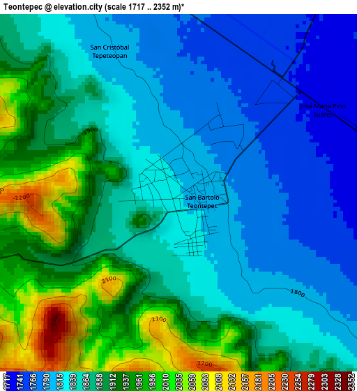
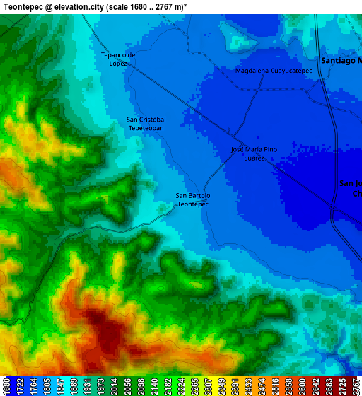
Below is the Elevation map of Teontepec, which displays elevation range with different colors. Scale of the first map is from 1717 to 2352 m (5633 to 7717 ft) with average elevation of 1869.5 meters (=6134 ft) [note 1]
These maps also provides idea of topography and contour of this city, they are displayed at different zoom levels. More info about maps, scale and edge coordinates you can find below images.
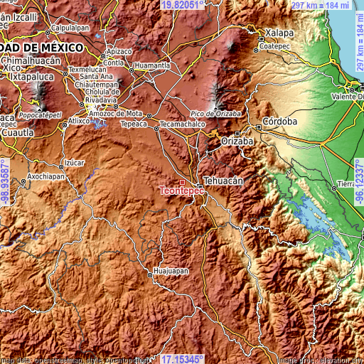
| \ | Map #1 | Map #2 | Topo.Map |
| Scale [m] | 1717..2352 m | 1680..2767 m | × |
| Scale [ft] | 5633..7717 ft | 5512..9078 ft | × |
| Average | 1869.5 m = 6134 ft | 1962.9 m = 6440 ft | × |
| Width | 9.27 km = 5.8 mi | 18.54 km = 11.5 mi | 296.5 km = 184.2 mi |
| Height | 9.27 km = 5.8 mi | 18.54 km = 11.5 mi | 296.6 km = 184.3 mi |
| ↑Max Latitude | 18.533841° | 18.575502° | 19.82051° |
| Latitude at center | 18.49217° | 18.49217° | 18.49217° |
| ↓Min Latitude | 18.450489° | 18.408797° | 17.15345° |
| ← Min Longitude | -97.573565° | -97.617511° | -98.93587° |
| Longitude center | -97.52962° | -97.52962° | -97.52962° |
| →Max Longitude | -97.485675° | -97.441729° | -96.12337° |
Nearby cities:
Cities around Teontepec sort by population:
• Tehuacán elevation 1643 m
14.3 km,  102°
102°
• Miahuatlán 1784 m
11.5 km,  55°
55°
• Magdalena Cuayucatepec 1741 m
8 km,  36°
36°
• San Andrés Cacaloapan 1892 m
11.8 km,  329°
329°
• San Isidro Vista Hermosa 1754 m
13.7 km,  83°
83°
• Tepanco 1816 m
7.9 km,  335°
335°
• Temalacayuca 1901 m
12.8 km,  346°
346°
• San José Monte Chiquito 1690 m
9.7 km,  87°
87°
• Francisco Ignacio Madero 1705 m
6.9 km, 89°
• Pericotepec 1909 m
16.6 km,  320°
320°
• Texcala 1686 m
13.8 km,  139°
139°
• Teloxtoc 1880 m
13.6 km,  203°
203°
Multilingual:
 En español:
Teontepec elevación 1817 m.
 En France:
Teontepec élévation 1817 m.
 Auf Deutsch:
Teontepec höhe über dem Meeresspiegel ist 1817 m.

Sources and notes:
- [note 1] Map square and city borders are not equal. Map elevation data is calculated only from area inside that square.
- [src 1] Elevation data from geonames database provided with same terms of usage.
- [src 2] The elevation map of Teontepec is generated using elevation data from NASA's 3 arcsec (90m) resolution SRTM data.
- [src 3] Base (background) map © OpenStreetMap contributors tiles are generated by Geofabrik and OpenTopoMap.
Copyright & License:
This Teontepec Elevation Map is licensed under CC BY-SA. You may reuse any part from this page, if you give a proper credit by linking to this URL:
 More info on terms of use page.